
Texas, Gulf Coast and Southeast Face Increasing Drought Risk Into Summer 2026 as IRI Forecast Shows Persistent Below-Normal Rainfall Signals
UNITED STATES — A newly released seasonal precipitation outlook from the International Research Institute (IRI) is raising concerns for parts of Texas, the Gulf Coast, and the Southeast heading into late spring and summer 2026.
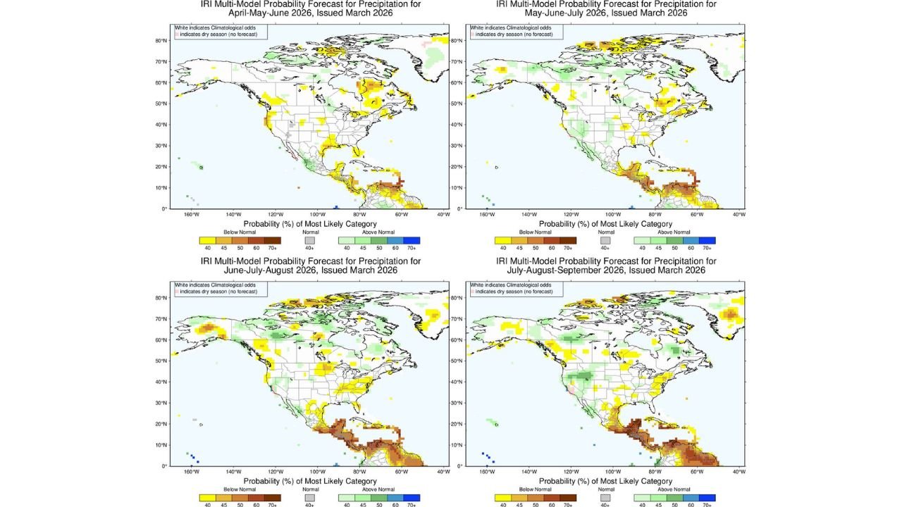
The IRI multi-model probability forecast, based on recalibrated output from NOAA’s North American Multi-Model Ensemble (NMME), highlights areas where below-normal rainfall is statistically favored through the upcoming warm season.
April–May–June 2026: Early Dry Signal in the South
For the April–May–June (AMJ) period, the strongest dry signals emerge across:
- South Texas
- Portions of the western Gulf Coast
- Parts of Mexico extending northward
While much of the central and northern United States remains near climatological averages (no strong signal), pockets of below-normal precipitation probabilities begin to show up in the southern tier.
The Midwest and Great Lakes region largely appear neutral during this early period, with no widespread strong wet or dry signal.
May–June–July: Drought Risk Expands Across the Southern U.S.
By May–June–July (MJJ), the dry anomaly zone becomes more defined:
- South Texas and the Rio Grande Valley
- Coastal sections of Texas and Louisiana
- Parts of the Gulf Coast extending toward the Southeast
The signal suggests increased odds of below-normal rainfall, which could stress agriculture and water resources if realized.
Meanwhile, scattered pockets of above-normal precipitation probabilities appear in parts of the West and northern tier, but signals remain relatively weak across the Midwest.
June–July–August: Southern Plains and Gulf Coast Remain Vulnerable
During the core summer period of June–July–August (JJA), the dry risk continues across:
- South and South-Central Texas
- Portions of the western Gulf Coast
- Areas near the U.S.–Mexico border
At the same time, parts of the northern Rockies and western Canada show modest above-normal precipitation probabilities.
The Midwest — including Illinois, Indiana, and surrounding states — trends largely neutral in this period, meaning no strong signal for either excessive wetness or drought.
July–August–September: Dry Bias Persists in Southern Tier
Looking further into July–August–September (JAS), below-normal precipitation probabilities remain concentrated across:
- Southern Texas
- Parts of the western Gulf Coast
- Northern Mexico
The Southeast shows mixed signals, with some localized areas leaning dry, but without a strong, widespread anomaly pattern.
Northern states and the Great Lakes again appear near climatological averages, indicating typical summer variability rather than a defined wet or dry regime.
What This Means for Texas and the Gulf Coast
If these projections verify:
- Soil moisture deficits could increase across South Texas
- Heat amplification may occur due to drier ground conditions
- Water management concerns could intensify by mid-summer
However, seasonal outlooks reflect probabilities — not guarantees. Thunderstorm-driven rainfall patterns in summer can be highly localized and difficult to predict months in advance.
Midwest and Northeast Outlook Remains Uncertain
For much of the Midwest, Great Lakes, and Northeast, the maps show broad areas of white or near-neutral shading. That indicates:
- Equal odds of above, near, or below-normal precipitation
- No dominant long-range wet or dry regime
This suggests typical variability driven by short-term weather systems rather than a persistent seasonal pattern.
Bottom Line Heading Into Summer 2026
The clearest long-range signal emerging from the IRI multi-model forecast is focused on:
- South Texas
- The Gulf Coast
- Parts of the southern tier of the United States**
Those regions face elevated probabilities of below-normal rainfall through summer.
Elsewhere, including much of the Midwest and Northeast, the outlook remains less definitive.
As always with seasonal forecasts, trends can shift based on ocean temperature patterns and evolving atmospheric signals.
Stay with ChicagoMusicGuide.com for continued national weather updates and long-range outlook analysis as we move deeper into the 2026 warm season.