
Texas, Louisiana, Mississippi and Illinois Set for Expanding Late-February to Early-March Warm Surge as Southern and Eastern U.S. Heat Builds Stronger Than Forecast
UNITED STATES — A broad and strengthening warm pattern is taking hold across the southern and eastern United States, with updated model guidance now indicating temperatures may verify even warmer than earlier outlooks suggested from late February into early March.
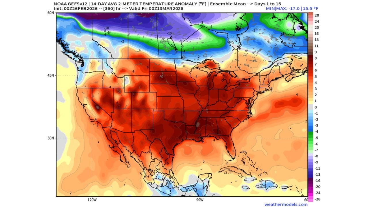
The latest ensemble temperature anomaly maps show widespread above-normal readings stretching from Texas and Louisiana through Mississippi, Alabama and Georgia, extending north into Missouri, Illinois, Indiana and Ohio, and reaching the Mid-Atlantic.
Southern States Leading the Warmth Surge
The most pronounced warmth is centered across:
- Texas
- Louisiana
- Mississippi
- Alabama
- Georgia
- Parts of Florida
Week 3/4 outlooks had already signaled “Much Above Normal” conditions for the Deep South. Now, 14-day ensemble averages reinforce that trend, with large swaths of the central and southern U.S. running several degrees above climatological norms.
Cities such as Houston, Dallas, New Orleans, Memphis and Atlanta are positioned in the core of the warm anomaly.
Illinois, Missouri and the Midwest Trending Warmer
Farther north, Missouri, Illinois, Indiana and Ohio sit within a growing zone of above-normal temperatures.
Chicago and much of Illinois fall in a region that transitions from neutral to solidly above-normal anomalies, particularly as warmer air expands northward from the southern Plains and lower Mississippi Valley.
While the northern Plains and Upper Midwest — including parts of Minnesota and North Dakota — may see cooler conditions at times, the broader Midwest trend favors warmth over the next two weeks.
Western Trough, Eastern Ridge Driving the Pattern
The temperature setup is tied to:
- Persistent troughing across the western United States
- A strong ridge building across the southern and eastern U.S.
- Southwest flow transporting mild air northward
This large-scale pattern supports sustained warmth from Texas through Illinois and into the Northeast.
The 500mb anomaly maps show higher-than-average heights across the eastern half of the country — a classic indicator of prolonged above-normal temperatures.
Even Warmer Than Expected?
Forecasters note that verification is trending warmer than earlier week 3/4 projections.
That means areas originally forecast as simply “Above Normal” may trend toward the higher end of that range — especially across:
- Texas
- Louisiana
- Mississippi
- Arkansas
- Missouri
- Illinois
In some southern locations, daytime highs could push into early spring territory well ahead of schedule.
What This Means for the Midwest
For Illinois — including Chicago — this pattern favors:
- Milder afternoon temperatures
- Reduced prolonged cold outbreaks
- Earlier hints of springlike days
However, with strong temperature contrasts still present between the cooler northern tier and warmer southern states, this setup can also support active storm tracks at times.
Bottom Line: Warm Pattern Locking In
The data increasingly supports a sustained warm stretch across Texas, Louisiana, Mississippi, Alabama, Georgia, Missouri and Illinois, with the southern and eastern United States verifying warmer than originally forecast.
As late February transitions into early March, the big-picture warmth idea appears to be panning out — and in some cases, exceeding expectations.
For continued updates on Midwest temperature trends and national pattern shifts, stay with ChicagoMusicGuide.com.