
Texas, Oklahoma and Kansas Face an Enhanced Severe Storm Risk Wednesday With Winds Exceeding 75 MPH, Two-Inch Hail and Tornadoes Possible From North Texas to Western Missouri
OKLAHOMA CITY, OK — A significant severe weather day is locked in for Wednesday, April 1 across the southern and central Plains, as a powerful storm system pushes an Enhanced Risk — the third-highest category on the national severe weather scale — directly over portions of Texas, Oklahoma, and Kansas, threatening millions of residents with damaging winds, large hail, and the possibility of tornadoes before the day is done.
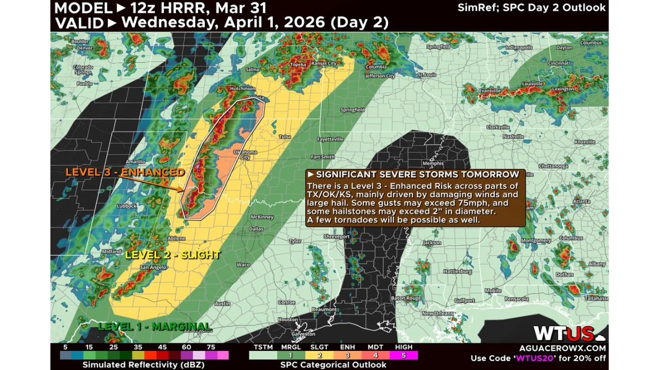
The threat is not subtle. Latest model data valid for Wednesday shows a tightly focused zone of organized severe storm activity targeting the western and central Oklahoma corridor southward into north Texas and northward through southern Kansas, with the window for dangerous conditions running through the afternoon and evening hours.
What Is Driving Wednesday’s Severe Weather Setup
Current analysis indicates the storm system arriving Wednesday will likely organize into a linear mode — meaning storms are expected to form into a fast-moving line rather than isolated rotating supercells. A linear storm mode shifts the primary hazard toward widespread damaging straight-line winds and large hail rather than tornadoes, though tornadoes are not off the table.
The on-map data confirms gusts from the most intense storm cells could exceed 75 mph — the equivalent of a Category 1 hurricane wind speed — capable of downing power lines, snapping trees, damaging rooftops, and creating dangerous driving conditions across open highways. Hailstones may reach 2 inches or more in diameter, which is larger than a golf ball and large enough to cause serious vehicle damage, break windows, and injure anyone caught outside without shelter.
Despite the linear storm expectation, the tornado threat is real. Storm track data indicates the main tornado corridor runs from North Texas northeast through Western Missouri, a swath that includes populated areas across Oklahoma and southern Kansas. A strong tornado remains possible within this corridor if any storms briefly organize into discrete supercell mode before the line consolidates.
Threat Level Breakdown by Risk Zone
The Storm Prediction Center Day 2 Outlook for Wednesday has issued the following categorical risk designations across the affected states:
Level 3 Enhanced Risk — The highest-risk designation in Wednesday’s outlook covers the core of western and central Oklahoma, the southern Kansas corridor including the Hutchinson and Wichita vicinity, and the north Texas panhandle fringe. This is where the combination of wind, hail, and tornado threats peaks simultaneously.
Level 2 Slight Risk — A broader zone extending from west Texas northward through Oklahoma into the Kansas and Missouri fringe. Damaging winds and large hail are the primary threats across this wider corridor, with isolated tornadoes possible.
Level 1 Marginal Risk — Covers a large region including south and central Texas through Houston and the Gulf Coast, extending east through Louisiana and Mississippi, and a separate marginal zone across Kentucky, Tennessee, and the Ohio Valley. Strong to isolated severe thunderstorms are possible but not expected to be widespread.
Wednesday Severe Weather Data Summary
| Threat | Level | Affected States | Key Values |
|---|---|---|---|
| Overall Risk (Core) | Level 3 Enhanced | Oklahoma, Kansas, North Texas | SPC Day 2 Outlook |
| Overall Risk (Broader) | Level 2 Slight | Texas, Oklahoma, Kansas, Missouri | SPC Day 2 Outlook |
| Overall Risk (Fringe) | Level 1 Marginal | S. Texas, Louisiana, Kentucky, Tennessee | SPC Day 2 Outlook |
| Wind Gusts | Damaging | Western/Central Oklahoma, S. Kansas | Exceeding 75 mph |
| Hail Size | Large | Enhanced Risk Core Zone | Exceeding 2 inches diameter |
| Tornado Threat | Possible/Strong | North Texas to Western Missouri | Linear + supercell mode |
| Storm Mode | Primarily Linear | Full corridor | Squall line likely |
State-by-State Risk for Wednesday
🔴 Oklahoma (Western and Central, Including Oklahoma City Vicinity) — Highest risk. The Level 3 Enhanced zone is centered directly over western and central Oklahoma. Damaging winds exceeding 75 mph, hail larger than 2 inches, and tornadoes are all possible. Residents in Oklahoma City and surrounding communities should monitor conditions closely throughout Wednesday afternoon and evening and have shelter plans in place before storms arrive.
🔴 Kansas (Southern, Including Hutchinson and Wichita Corridor) — High risk. The Enhanced zone extends into southern Kansas, where the same combination of high winds, large hail, and tornado potential applies. The Wichita metro sits at the northern edge of the highest-risk corridor and should be on alert.
🟠 Texas (North Texas to Panhandle Fringe, Including Dallas-Fort Worth Vicinity) — Elevated risk. North Texas falls inside both the Enhanced and Slight risk zones depending on exact location. The tornado corridor running from North Texas to Western Missouri passes directly through this region. Damaging wind gusts and large hail are expected. The Dallas-Fort Worth area sits within the Slight Risk zone and should not be treated casually.
🟠 Missouri (Western) — Elevated risk. Western Missouri sits at the northern end of the tornado corridor identified in current analysis. The Level 2 Slight Risk covers this area, with damaging winds and tornado potential as storms push northeast through the evening hours.
🟡 Texas (South and Central, Including Houston and the Gulf Coast) — Marginal risk. A Level 1 Marginal designation covers south and central Texas through the Houston metro and Gulf Coast. Isolated strong to severe thunderstorms are possible, but organized severe weather is not expected to be widespread in this zone.
🟡 Louisiana, Mississippi and the Gulf Coast States — Marginal risk. Storms pushing southeast may produce isolated severe weather, but conditions here are less favorable for organized severe storm development Wednesday.
🟡 Kentucky, Tennessee and the Ohio Valley — Marginal risk. A separate area of marginal severe weather potential exists across the Ohio Valley, driven by a different part of the storm system. Damaging wind gusts and large hail are the primary concerns here.
🟢 Arkansas, Missouri (Eastern), Illinois (Southern) — Low risk. These areas are on the periphery of the storm system and outside the primary severe weather corridors for Wednesday.
Forecast Confidence
Forecast Confidence: Moderate to High for a significant severe weather event across the Level 3 Enhanced corridor covering Oklahoma and southern Kansas on Wednesday. The large-scale forcing is well-established and the model is consistent in placing the highest storm energy over this zone.
The primary uncertainty is storm mode. If the system maintains discrete supercell organization longer than currently expected before transitioning to a squall line, the tornado threat increases significantly above current projections. If it consolidates into a line earlier, the wind damage threat becomes the dominant hazard across a broader area. Either outcome produces a dangerous event. All residents inside the Enhanced and Slight Risk zones should have a weather plan in place, a reliable alert source active, and know the location of their nearest sturdy shelter before Wednesday afternoon.
More severe storm coverage is always on the horizon. Stay informed at ChicagoMusicGuide.com — your source for Plains severe weather and tornado outbreak tracking across Texas, Oklahoma, Kansas, and the entire United States.