
Texas, Oklahoma and Kansas Highlighted in First 2026 Severe Season Map as Elevated Thunderstorm Risk Targets the Southern Plains
UNITED STATES — The first meaningful severe weather signal of the 2026 season is emerging across the Southern Plains, with forecast guidance highlighting an elevated risk zone centered over Texas, Oklahoma and Kansas.
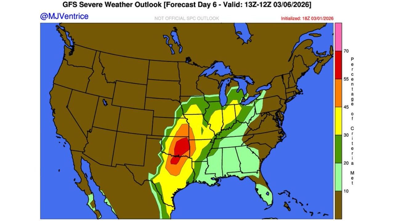
Long-range outlook maps valid for early March show a 15% severe probability corridor stretching from central and northern Texas through much of Oklahoma and into southern Kansas, marking the first organized severe threat of the new season.
15% Risk Corridor Focused on Texas and Oklahoma
The Day 6 severe weather outlook places the core threat area across:
- Central and North Texas
- Much of Oklahoma
- Southern Kansas
Cities near or within the highlighted zone include:
- Dallas
- Fort Worth
- Wichita Falls
- Oklahoma City
- Tulsa
- Parts of southern Kansas
The elongated risk area suggests a classic early-season Plains setup, where instability and wind shear overlap along a developing frontal boundary.
Threats: Hail, Damaging Winds and Isolated Tornadoes
Forecast discussions indicate strong thunderstorms may develop capable of producing:
- Large hail
- Damaging straight-line winds
- Isolated tornadoes
While this is not currently projected as a widespread high-end outbreak, it represents the first structured severe signal of 2026 for the Southern Plains.
Early March systems often bring dynamic wind fields, and if moisture return from the Gulf of Mexico strengthens, supercell development becomes more plausible.
Comparison to Broader Severe Signals
One long-range model depiction suggests a broader severe zone extending northeastward into parts of the Midwest and lower Mississippi Valley. However, the more focused probability map keeps the highest organized risk centered squarely over Texas, Oklahoma and Kansas.
This narrowing of the threat area suggests:
- The strongest dynamics will align over the Southern Plains
- Storm initiation will likely focus along a defined boundary
- Confidence is increasing for organized severe storms in that corridor
Why This Matters for 2026’s Severe Season
The Southern Plains — particularly Texas and Oklahoma — often serve as the launch point for the nation’s severe weather season.
An early March elevated risk does not guarantee a major outbreak, but it signals that:
- Springlike atmospheric patterns are beginning to establish
- Wind shear profiles are strengthening
- Moisture transport is becoming sufficient for organized storms
For areas like Dallas–Fort Worth and Oklahoma City, this marks the transition toward a more active weather regime.
Bottom Line
Texas, Oklahoma and southern Kansas sit within a 15% severe weather probability zone in the first notable severe outlook of the 2026 season. Strong thunderstorms capable of hail, damaging winds and isolated tornadoes are possible.
As forecast details sharpen in the coming days, residents across the Southern Plains should begin monitoring updates closely.
ChicagoMusicGuide.com will continue tracking the evolution of the 2026 severe weather season as the Southern Plains enter a more active phase.