
Texas, Oklahoma, Arkansas, and Mississippi Face Multi-Day Severe Weather Threat as Storm System Shifts East This Week
UNITED STATES — A dynamic and evolving storm pattern is setting up across the central and southern United States this week, bringing strong to potentially severe thunderstorms, heavy rain, fog, and possible tornado threats from Texas and Oklahoma into the Lower Mississippi Valley, before shifting eastward toward the Southeast.
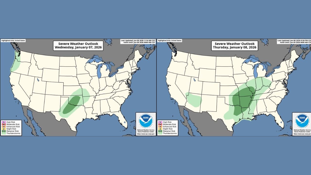
Forecast models and Storm Prediction Center outlooks show multiple rounds of unsettled weather from Wednesday night through Friday, with the highest severe potential emerging by the end of the week.
Wednesday Night: Strong Storms Develop From West-Central Texas Into Oklahoma
Storm activity is expected to increase Wednesday night into early Thursday, particularly across west-central and central Texas extending into Oklahoma.
At this stage, storms are expected to be elevated, meaning they form above the surface. While this limits tornado potential initially, the environment still supports:
- Isolated large hail
- Strong, damaging wind gusts
- Intense lightning
The SPC has placed parts of Texas and Oklahoma under a Marginal Risk (Level 1 of 5), reflecting conditional but noteworthy severe potential overnight.
Thursday: Isolated Severe Storms Expand Eastward
By Thursday, the storm threat shifts east into:
- Eastern Texas
- Oklahoma
- The Ozarks
- Lower and Mid-Mississippi Valley
Atmospheric instability on Thursday is expected to be marginal and imperfect, meaning storms may struggle to organize. However, if storms can develop in the most favorable zones, low-end all-hazards severe weather remains possible.
Potential impacts include:
- Damaging straight-line winds
- Large hail
- A brief tornado risk
Storm coverage may be scattered, but any storm that becomes established could intensify quickly due to strong wind shear shown in model guidance.
Friday: Higher Severe Weather Risk Emerges Across the Lower Mississippi Valley
Confidence increases significantly by Friday, as forecast data shows a more organized storm system moving through the region.
The SPC has maintained a Slight Risk (Level 2 of 5) for parts of:
- Arkansas
- Mississippi
- Louisiana
- Western Tennessee
While the surface low is expected to track slightly farther south than earlier projections, widespread severe storms remain likely, with the potential for:
- Damaging winds
- Large hail
- Tornadoes
All-hazards severe weather is possible if storms can tap into the most unstable air ahead of the advancing cold front.
Heavy Rainfall Adds Flooding Concerns
ECMWF ensemble guidance highlights a significant rain axis from eastern Texas through Alabama, with 2 to 3 inches of rainfall possible, particularly across north and central Alabama.
Rainfall amounts decrease farther south, but localized flooding issues cannot be ruled out where storms repeatedly track over the same areas.
This rainfall will be beneficial in drought-prone locations, but could cause temporary travel disruptions and poor drainage flooding.
Fog and Travel Hazards Across Alabama
Ahead of the main storm system, a Dense Fog Advisory is in effect for much of Alabama, with visibility sharply reduced through the overnight hours into mid-morning.
Drivers are urged to use caution, especially along rural roads and interstates where visibility may drop rapidly.
Cold Front Brings Snow Potential to the Great Lakes and Upper Midwest
Behind the storm system, colder air is expected to wrap in from the northwest, allowing rain to change to snow across parts of the Great Lakes region.
Some model guidance suggests localized snowfall totals of up to 8 inches, though final accumulation will depend heavily on temperature trends late in the week.
What Happens Next
Forecast confidence will continue to improve as the event approaches, and risk areas may shift north or south depending on the final track of the storm system.
Residents across the Southern Plains, Lower Mississippi Valley, and Southeast should stay alert for forecast updates, especially if travel or outdoor plans are scheduled later this week.
For the latest updates on how this evolving weather pattern could impact your area, keep checking forecasts and follow ongoing coverage at ChicagoMusicGuide.com, where we continue to track major weather events affecting communities nationwide.