
Texas, Oklahoma, Arkansas and Missouri Highlighted in Week 2 Severe Weather Signal as Early March Storm Pattern Strengthens Toward Illinois
UNITED STATES — Long-range guidance is increasingly pointing toward a potentially active stretch of severe weather during the first half of March, with a pronounced corridor of supercell-favorable conditions extending from Texas and Oklahoma through Arkansas and Missouri, and edging toward the Mid-Mississippi Valley.
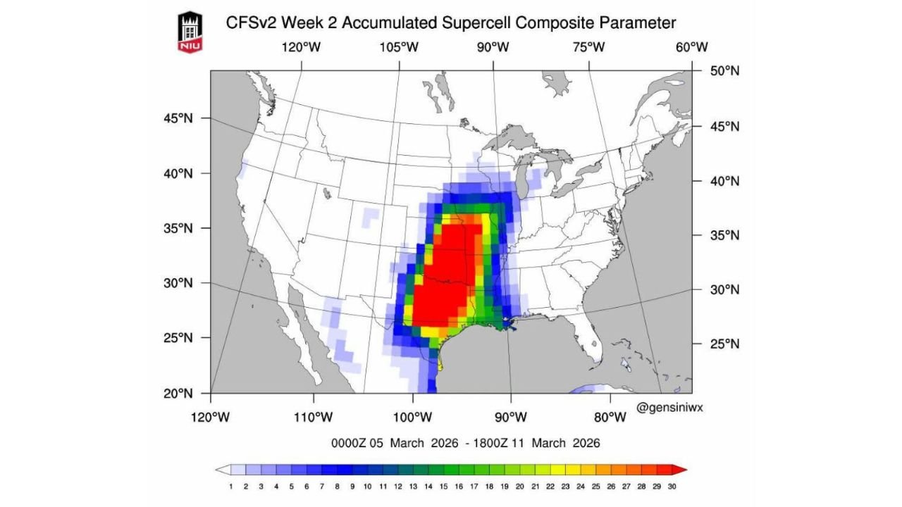
The latest Week 2 CFSv2 accumulated supercell composite parameter map highlights a concentrated zone of elevated values from central and eastern Texas into Oklahoma, Arkansas and Missouri, covering the period from March 5 through March 11, 2026.
While this does not guarantee specific outbreaks, it does signal a pattern supportive of organized thunderstorms — including supercells — across parts of the Southern and Central Plains.
Core Severe Corridor: Texas to Missouri
The most intense signal (shown in red on the map) is centered across:
- Central and Eastern Texas
- Oklahoma
- Western and Central Arkansas
- Southern and Central Missouri
Cities that fall within or near this highlighted zone include:
- Dallas and Fort Worth, Texas
- Oklahoma City, Oklahoma
- Little Rock, Arkansas
- Springfield and St. Louis, Missouri
This corridor aligns with a classic early-season severe weather setup, where Gulf moisture surges northward beneath strengthening upper-level winds.
Mid-Mississippi Valley Watching Closely
The signal also stretches into parts of:
- Eastern Missouri
- Western Illinois
- Portions of the broader Mid-Mississippi Valley
Although the strongest anomalies remain just south and southwest of Chicago, the proximity of this corridor means Illinois cannot be ruled out for potential thunderstorm episodes if the pattern verifies as projected.
What the Supercell Composite Means
The supercell composite parameter combines ingredients such as:
- Instability (CAPE)
- Wind shear
- Low-level helicity
- Lift mechanisms
Elevated composite values suggest the atmosphere may become supportive of organized rotating storms, particularly if moisture return from the Gulf of Mexico aligns with upper-level dynamics.
Again, this is a longer-range outlook — but strong signals this far out often indicate a broader pattern shift toward severe weather season.
Early March Pattern Shift Underway
The guidance supports the idea that the Southern and Central Plains — especially Texas, Oklahoma and Arkansas — may be transitioning into a more active severe weather regime.
This typically coincides with:
- Increasing Gulf moisture transport
- Strengthening jet stream energy
- Sharper temperature contrasts across the Plains
When those ingredients overlap, severe thunderstorms become more likely.
Implications for Illinois and the Midwest
For Illinois, including the Chicago region, this setup suggests:
- An increasingly active storm track to the southwest
- The possibility of strong thunderstorm systems tracking northeast
- A gradual ramp-up toward spring storm season
While the highest confidence severe corridor remains from Texas through Missouri, patterns can shift northward as we move deeper into March.
Bottom Line
A notable Week 2 severe weather signal is developing from Texas and Oklahoma through Arkansas and Missouri, with early March potentially marking the beginning of a more active storm season across the Southern and Central Plains.
Illinois sits near the northern fringe of this corridor, meaning the Midwest will need to monitor how moisture and upper-level energy align over the coming weeks.
Severe weather season appears to be knocking on the door.
For continued updates on Plains storm signals and Midwest impacts, stay with ChicagoMusicGuide.com.