
Texas, Oklahoma, Arkansas, Mississippi, Alabama, and Georgia Face Increasing Severe Weather Risk This Weekend as Powerful Storm System Takes Shape
UNITED STATES — A developing storm system is raising concern across the Southern Plains and Southeast, with Texas, Oklahoma, Arkansas, Mississippi, Alabama, and Georgia all facing a renewed risk of severe weather this weekend. Forecast models indicate the potential for damaging winds, strong thunderstorms, and a few tornadoes from Saturday into Sunday, though meteorologists stress that it is still too early to pinpoint exact timing or the hardest-hit locations.
What is becoming clearer, however, is that the overall pattern is turning more favorable for severe storms after a relatively quiet stretch.
Strong Storm System Expected To Emerge From The Southern Plains
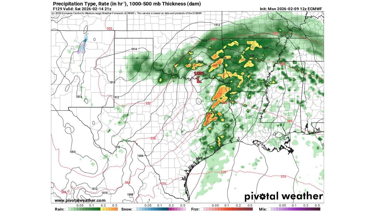
Forecast guidance shows a strengthening low-pressure system developing over parts of Texas and Oklahoma, then tracking eastward into the Lower Mississippi Valley and Southeast. As this system intensifies, it is expected to draw warm, moist air northward from the Gulf of Mexico, setting the stage for thunderstorm development.
The most organized storms are currently projected to form along and ahead of a cold front, with activity expanding from Texas and Arkansas eastward into Mississippi and Alabama, and eventually toward Georgia.
Damaging Winds And Tornadoes Possible Saturday Into Sunday
At this early stage, forecasters highlight damaging straight-line winds as the primary threat, particularly with any fast-moving squall lines that develop. Embedded thunderstorms within these lines could also produce isolated tornadoes, especially where wind shear and instability briefly overlap.
While tornado coverage is expected to remain limited, even a few storms could become severe if atmospheric conditions align at the right time.
Importantly, meteorologists caution that specifics on timing, storm mode, and intensity will evolve over the coming days as higher-resolution data becomes available.
Heavy Rain And Thunderstorms Spread Eastward
In addition to severe wind potential, widespread rain and thunderstorms are likely across a broad swath of the region. Areas from eastern Texas through Mississippi and Alabama could see repeated rounds of rainfall, while Georgia may experience storms later in the weekend as the system shifts east.
While flooding is not currently the main concern, localized heavy downpours could still cause brief issues in low-lying or poor-drainage areas.
Why Forecast Confidence Is Still Limited
Although the overall severe weather signal is present, forecasters emphasize that key details remain uncertain, including:
- The exact track of the surface low
- How quickly storms organize
- Whether storms remain discrete or merge into lines
- The degree of instability available during peak storm hours
Small changes in any of these factors can significantly alter the severity and location of impacts.
What Residents Should Do Now
Residents across Texas, Oklahoma, Arkansas, Mississippi, Alabama, and Georgia are encouraged to stay weather-aware through the end of the week. This includes reviewing severe weather safety plans, ensuring access to weather alerts, and monitoring updated forecasts as confidence improves.
As with many early-season severe weather setups, preparation and awareness are key — even if the final impacts turn out to be more limited than early signals suggest.
As the Southern Plains and Southeast head into the weekend with an increasing severe weather threat, updates are expected as the storm system comes into clearer focus. For continued coverage of evolving forecasts, storm risks, and weather-related impacts across the country, visit ChicagoMusicGuide.com for the latest updates.