
Texas, Oklahoma, Arkansas, Mississippi, Tennessee, Kentucky, Indiana, and Ohio Placed Under Marginal Severe Storm Risk Ahead of Friday System
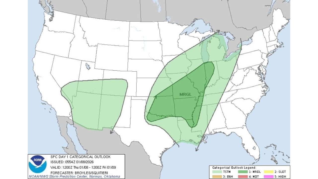
UNITED STATES — A broad swath of the central and eastern United States is under a Marginal Risk for severe storms as forecast models continue to lock in a dynamic weather setup stretching from the southern Plains into the mid-Mississippi Valley and lower Ohio Valley late Thursday into Friday, according to the Storm Prediction Center (SPC).
Latest SPC Day 1 outlooks show two separate risk zones, with the more impactful corridor extending from eastern Texas and Oklahoma northeastward through Arkansas, Mississippi, Tennessee, Kentucky, Indiana, and Ohio, where atmospheric conditions may support strong thunderstorms, damaging winds, and localized flooding.
A Broad Multi-State Risk Zone Takes Shape
Forecast maps highlight a long, arcing Marginal Risk area beginning in the southern Plains and expanding northeast across the Mississippi River Valley into the Ohio Valley. This type of setup often reflects widespread instability paired with limited but notable severe potential, especially during winter transition seasons.
States most directly included in the core risk zone include:
- Texas (eastern sections)
- Oklahoma
- Arkansas
- Mississippi
- Tennessee
- Kentucky
- Indiana
- Ohio
A secondary, weaker Marginal Risk area is also present farther west across parts of the Southwest, but forecasters emphasize that the central U.S. corridor poses the more organized concern due to better overlap of moisture, wind energy, and lift.
Why This Setup Has Meteorologists Watching Closely
This system is being driven by a strong upper-level disturbance ejecting eastward, allowing Gulf moisture to surge north ahead of an advancing cold front. Forecast soundings indicate increasing wind shear and rising dew points, which can support organized thunderstorms even in cooler months.
While instability levels are not extreme, strong wind profiles aloft raise the possibility of:
- Isolated damaging wind gusts
- Embedded stronger storms within rain bands
- Brief spin-up tornado potential, especially near boundaries
- Heavy downpours leading to localized flash flooding
SPC forecasters note that wintertime severe events often carry lower coverage but higher uncertainty, making it important for residents across the risk area to remain weather-aware.
Timing: When Storms Are Most Likely
Current guidance suggests storms may begin developing late Thursday evening across the southern Plains before intensifying and spreading eastward overnight into Friday morning and afternoon.
The mid-Mississippi Valley and Ohio Valley could see the most organized activity during daytime heating Friday, when instability and wind energy overlap more effectively. Even areas that experience widespread rain earlier in the day could see renewed storm development as the cold front advances.
What “Marginal Risk” Really Means for Residents
A Marginal Risk does not mean severe weather is guaranteed, but it does signal that isolated severe storms are possible, particularly in pockets where storms can briefly intensify.
Impacts may be uneven — some communities may see little more than steady rain, while others could experience strong gusts, power disruptions, or brief flooding. This kind of risk category often produces surprise impacts, especially overnight or during commute hours.
What to Watch as the Forecast Evolves
Meteorologists will be closely monitoring:
- The northward extent of warm, humid air
- How quickly cloud cover clears ahead of the front
- The strength of low-level wind shear
- Any upgrades in SPC risk levels
Even a small shift in these factors could increase or decrease storm intensity, particularly across the Ohio Valley states.
Stay Informed as Conditions Develop
Forecast confidence typically improves within 24 hours of the event, and updated outlooks may refine the risk zones or timing. Residents across the affected states should ensure they have multiple ways to receive weather alerts, especially overnight.
What are you seeing where you live — steady rain, gusty winds, or changing skies? Share your local conditions and stay connected with ongoing weather coverage at ChicagoMusicGuide.com.