
Texas, Oklahoma, Arkansas, Missouri and Southern Iowa Face Multi-Day Tornado Threat as 33 Million Remain Under Severe Weather Risk Through Saturday
UNITED STATES — A volatile spring setup is unfolding across the central United States, placing an estimated 33 million people at risk for severe weather from Wednesday through Saturday, with the most concerning period targeting parts of Texas, Oklahoma, Arkansas, Missouri and southern Iowa.
Forecasters indicate that a “Slight Risk” is in place each day during this stretch, with Friday emerging as the day to watch most closely for a potentially more significant severe weather outbreak — including tornadoes.
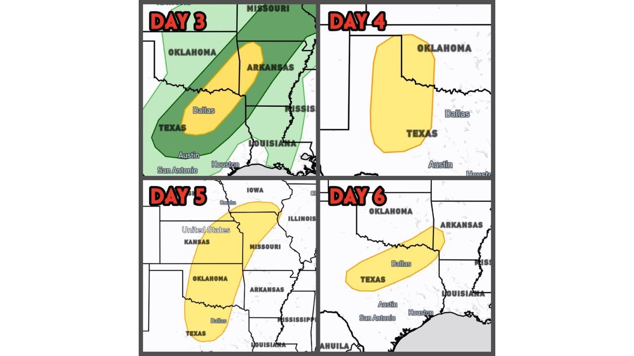
Wednesday: North Texas into Southeast Oklahoma and Western Arkansas
The first round focuses on North Texas, extending into southeast Oklahoma (SEOK) and western Arkansas.
Primary concerns:
- Damaging straight-line winds
- Large hail
- A conditional, brief tornado risk
Storm development may depend on localized atmospheric conditions, but the corridor from Dallas northward into Oklahoma and Arkansas sits squarely in the highlighted zone.
Thursday: Texas Panhandle into Western Oklahoma
Thursday’s risk shifts westward and slightly north, centering on:
- The Texas Panhandle
- Western Oklahoma
Forecast guidance suggests a conditional significant severe weather setup — meaning if storms fully develop, all hazards could be in play. That includes:
- Large hail
- Damaging winds
- Tornado potential
The key uncertainty remains whether storms will “fire” efficiently given atmospheric dynamics.
Friday: Southern Iowa to North Texas — Highest Tornado Concern
Friday currently appears to carry the greatest overall threat window.
The risk zone stretches from:
- Southern Iowa
- Across Missouri
- Through Kansas
- Into Oklahoma
- Down to North Texas
All severe hazards are expected to be possible, including:
- Strong damaging winds
- Significant hail
- A more organized tornado risk
Forecast models suggest the possibility of a future categorical upgrade if parameters align. Timing and storm mode will become clearer as the week progresses.
Saturday: North Texas into Oklahoma and Arkansas
The pattern remains active into Saturday, with severe potential again centered on:
- North Texas
- Oklahoma
- Arkansas
All hazards remain possible. However, forecasters note that cloud cover could limit daytime heating and slightly reduce overall instability. That said, even marginal instability in a dynamic setup can still support severe storms.
What This Means for the Region
This multi-day setup reflects a classic early-season severe weather pattern across the southern Plains into the Midwest. With repeated rounds possible, impacts could include:
- Localized flooding from repeated storms
- Infrastructure strain from wind damage
- Tornado watches and warnings, especially Friday
Major metro areas potentially affected during this stretch include:
- Dallas, Texas
- Oklahoma City, Oklahoma
- Little Rock, Arkansas
- Kansas City, Missouri
- Portions of southern Iowa
Bottom Line
A broad and active severe weather corridor from Texas through the Midwest will remain under threat through Saturday, with Friday currently standing out as the day with the greatest tornado potential.
Residents across Texas, Oklahoma, Arkansas, Missouri and southern Iowa should closely monitor daily updates as storm timing and intensity details sharpen.
ChicagoMusicGuide.com will continue monitoring this developing severe weather pattern and provide updates as new forecast data becomes available.