
Texas, Oklahoma, Arkansas, Tennessee and Carolinas Brace for High-Impact Winter Storm With Snow, Ice and Dangerous Cold
UNITED STATES — A major winter storm is increasingly likely to impact a broad swath of the country beginning late Friday and lasting through the weekend, with Texas, Oklahoma, Arkansas, Tennessee, North Carolina, South Carolina and Virginia facing dangerous combinations of heavy snow, crippling ice accumulation and extreme cold, according to the latest model guidance and impact maps.
Forecast confidence is growing that a powerful Arctic air mass will collide with deep Gulf moisture, setting the stage for a high-impact winter weather event capable of disrupting travel, knocking out power, and creating life-threatening conditions across the South and parts of the East Coast.
Storm Setup and Why This System Is Dangerous
This developing system features a strong Canadian high-pressure dome pushing frigid air deep into the southern United States, while a developing low-pressure system tracks eastward from the Southern Plains toward the Southeast and Atlantic Coast.
That setup creates a classic cold-air damming and overrunning scenario, where warm, moisture-laden air rides over entrenched surface cold. The result is a wide zone of snow north, icy mix in the transition zone, and freezing rain south of the snow line—a configuration known for producing long-duration ice storms.
Meteorologists are closely monitoring this system because even small shifts in the storm track could dramatically change who receives heavy snow versus damaging ice.
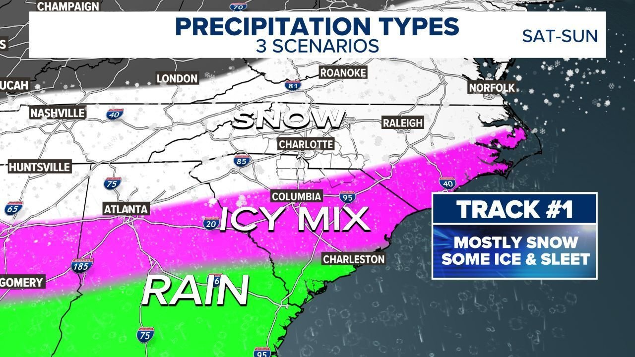
Three Precipitation Scenarios Being Watched
Current guidance outlines three primary storm tracks, each with different—but serious—impacts for the region.
Track #1: Colder Solution (Mostly Snow / Snow-Dominant Mix)
In this scenario, the low tracks slightly farther south, keeping cold air locked in place. This would bring heavy snow closer to northern North Carolina and southwest Virginia, with mountains and foothills seeing significant accumulations. Cities like Charlotte would still see an icy mix, but with a better chance of transitioning to snow, limiting ice accretion.
Track #2: Snow to Ice “Glacier” Scenario
This middle-ground track pushes warmer air aloft while surface temperatures remain below freezing. Snow would quickly transition to sleet and freezing rain, creating a hard-packed ice layer that is extremely difficult to clear from roads. This scenario raises concerns for prolonged power outages, especially across central and eastern North Carolina.
Track #3: Crippling Ice Storm (Worst-Case Outcome)
If the low tracks farther north and inland, warm air overwhelms the snow zone while surface cold remains entrenched. This places North Carolina, South Carolina and parts of Virginia in the bullseye for major freezing rain, with heavy ice accretion capable of snapping tree limbs, collapsing power lines and causing multi-day outages.
Expected Impacts by Region
Texas and Oklahoma:
Portions of North Texas and southern Oklahoma could see ice accumulations combined with temperatures 35–40 degrees below normal, similar to impacts experienced during February 2021. Power disruptions and dangerous road conditions are possible.
Arkansas and Tennessee:
These states sit near the transition zone, meaning forecast uncertainty remains high. Heavy snow is possible in northern areas, while significant icing threatens central and eastern sections.
North Carolina and South Carolina:
Confidence is increasing that much of central and western North Carolina, including the Charlotte metro, will experience prolonged icy conditions, with snow possible north and rain south. This is a high-risk zone for power outages.
Virginia:
Snow potential increases moving north toward southwest and central Virginia, though a shift in track could also introduce icing concerns.
Why Preparation Needs to Start Now
Even though precise snowfall and ice totals will not be finalized until later in the week, the Friday through Sunday window is increasingly likely to bring dangerous travel conditions, school and event disruptions, and extended power outages.
Residents in impacted states should begin preparing by securing alternative heat sources, stocking food, water and medications, and checking on elderly neighbors and family members. Those without generators should be ready for rapid indoor temperature drops if power is lost.
As this winter storm threat continues to evolve, ChicagoMusicGuide.com will provide updated weather coverage, safety guidance, and impact analysis as new data becomes available. Stay informed, prepare early, and check back often for the latest developments.