
Texas, Oklahoma, Arkansas, Tennessee, Carolinas and Virginia Face Dangerous Winter Storm With Ice, Snow and Brutal Wind Chills
UNITED STATES — A major winter storm is shaping up to impact a large portion of the country beginning Friday and continuing through the weekend, with Texas, Oklahoma, Arkansas, Tennessee, North Carolina, South Carolina and Virginia facing a dangerous combination of snow, freezing rain, power outages and extreme wind chills. While some forecast models may be overestimating totals, meteorologists stress that the overall threat remains serious and potentially life-threatening.
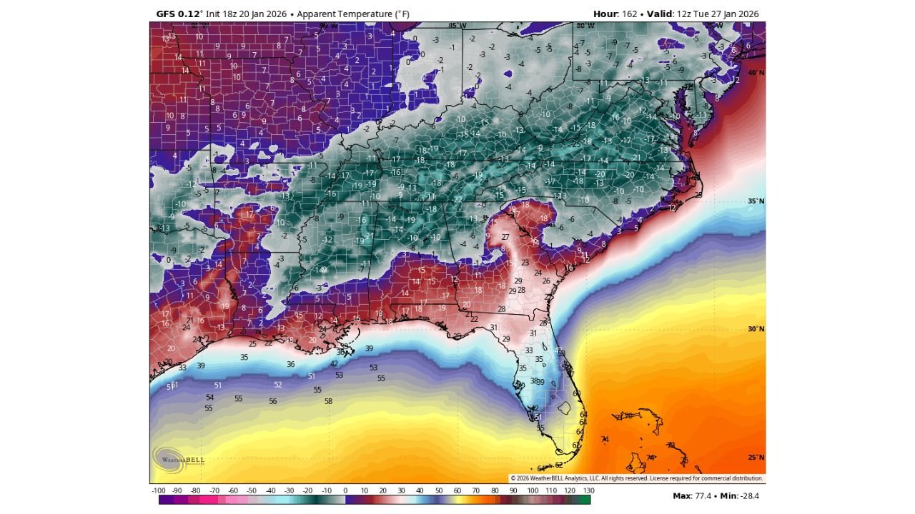
Even moderate snowfall or ice in the Deep South and Southeast can quickly turn dangerous when paired with Arctic air, and current guidance shows wind chills dropping well below actual air temperatures, in some cases into the single digits or even below zero across parts of the region.
Why Wind Chill and Ice Are the Biggest Threats
While snowfall totals will vary by location, wind chill and ice accumulation are emerging as the most dangerous aspects of this storm. Forecast data shows that once heavy snow and ice take hold, strong winds will drive apparent temperatures far colder than the thermometer suggests.
In many areas, actual air temperatures may fall into the teens and lower 20s, but wind chills could plunge 10 to 20 degrees colder, creating conditions dangerous for anyone without reliable heat. These values are especially concerning across Texas, Arkansas and Tennessee, where homes and infrastructure are less equipped for prolonged cold.
Ice accumulation is also a major concern. Even a thin layer of freezing rain can be enough to bring down trees and power lines, especially when combined with gusty winds and saturated ground.
Power Outages Could Become a Life-Safety Issue
With major ice accumulation likely in parts of the Southeast, widespread power outages are a realistic possibility. The danger does not stop when the lights go out — it intensifies.
Without electricity, indoor temperatures can drop rapidly, especially in homes not designed for extended freezes. This creates serious risks for elderly residents, children, and anyone with medical needs that require power or heat.
Meteorologists are urging residents to plan ahead now, not after freezing rain begins. Once roads ice over, travel becomes extremely dangerous or impossible, limiting access to warming centers or emergency services.
Regional Breakdown of Expected Impacts
Texas and Oklahoma:
North and central Texas could see impacts comparable in setup — though not necessarily scale — to February 2021, with ice, bitter cold and power disruptions possible. Temperatures are forecast to run 35–40 degrees below normal, making even short outages dangerous.
Arkansas and Tennessee:
These states lie near the transition zone, where precipitation type is hardest to pin down. Some areas may see snow at the start before changing to sleet or freezing rain, increasing the risk of prolonged icing and travel shutdowns.
North Carolina and South Carolina:
Confidence is increasing that much of central and western North Carolina, including metro areas, will experience a long-duration icy mix. This is one of the highest-risk regions for tree damage and extended outages, especially if freezing rain dominates.
Virginia:
Parts of Virginia could remain cold enough for snow, but a northward storm track would push snow farther north and expand the freezing rain zone, raising outage concerns.
What Residents Should Do Before the Storm Arrives
Emergency planners and meteorologists strongly recommend taking action before freezing rain begins, not during it.
If you do not have a reliable and safe source of heat without electricity, now is the time to:
- Arrange to stay with family or friends who do
- Identify a public warming shelter in your area
- Stock up on food, water, medications and blankets
- Charge devices and prepare battery-powered lighting
Avoid using unsafe heating methods such as grills or generators indoors, which can lead to carbon monoxide poisoning.
Forecast Confidence and What Happens Next
While individual models such as the GFS may be overstating some extremes, forecasters emphasize that the overall signal is consistent: a widespread winter weather event with dangerous cold following heavy snow and ice.
The exact placement of snow versus freezing rain will become clearer over the next 24 to 48 hours, but the Friday through Sunday timeframe is increasingly locked in as the period of greatest impact.
As this significant winter storm threat continues to evolve, ChicagoMusicGuide.com will keep tracking forecast updates, impact zones, and safety guidance. Stay alert, prepare early, and continue checking back for the latest information as new data comes in.