
Texas, Oklahoma, Arkansas, Tennessee, Georgia, North Carolina, and South Carolina Face Potential Major Southern Winter Storm Late Jan. 24–26 With Snow and Ice Risks Rising
UNITED STATES — Forecast confidence is increasing that a rare and potentially impactful Southern U.S. winter storm could develop late this week into the weekend, affecting a broad corridor from Texas and Oklahoma through Arkansas, Tennessee, and into parts of Georgia, North Carolina, and South Carolina. Recent ensemble and deterministic model runs indicate a high-impact setup with cold Arctic air in place as widespread moisture approaches from the west, creating a favorable environment for snow, sleet, and freezing rain.
Why Meteorologists Are Increasing Concern Across the South
Latest guidance from ECMWF (Euro), EPS ensembles, and GEFS shows a persistent signal for a large-scale winter system developing as early as Friday in the southern Plains before expanding eastward through the Mid-South and Southeast. What stands out in this setup is the strength of the cold air source, with surface high pressure exceeding 1035–1040 mb pressing southward while upper-level energy ejects across the Southern U.S.
This classic overrunning pattern—where warm, moisture-rich air rides over shallow Arctic air—raises red flags for ice accretion, particularly in areas that sit just south of the heaviest snow band. Forecasters stress that while exact placement will shift, the overall signal has remained steady across multiple model cycles, increasing confidence in a high-impact event somewhere in the region.
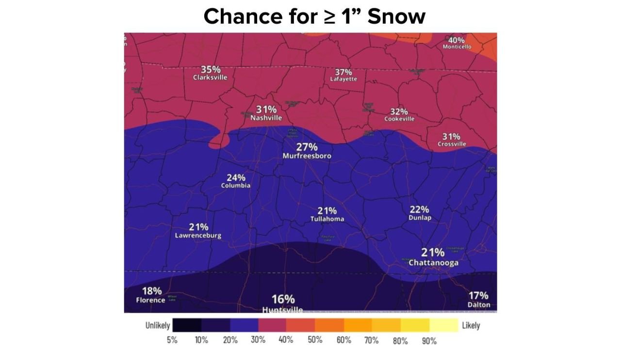
Snow Potential From Oklahoma to Tennessee Is Trending Higher
One of the more notable recent trends is a significant uptick in snowfall probabilities across Oklahoma, including the Oklahoma City metro, where ensemble guidance now shows near-50% odds of 4 inches or more of snow in some runs. Snow probabilities of 1 inch or greater extend eastward across northern Texas, Arkansas, and into Middle Tennessee, with cities such as Nashville, Clarksville, and Cookeville showing measurable accumulation potential.
Further east, model snowfall output highlights a swath of accumulating snow extending into parts of North Carolina, particularly inland areas where cold air is more firmly established. A northward or southward shift of the storm track could dramatically change snowfall totals, but confidence is growing that at least some portion of this corridor will see impactful snow.
Ice Storm Signal Raises Red Flags for the Southeast
Perhaps the most concerning aspect of this forecast is the strong ice storm signal shown in multiple EPS and ECMWF freezing rain outputs. Forecast maps indicate freezing rain QPF exceeding 0.25 inches in parts of Georgia, South Carolina, and southern North Carolina, with locally higher amounts possible if cold air remains entrenched.
Ice accumulations of this magnitude can lead to power outages, tree damage, and dangerous travel, even if snowfall totals remain modest. Meteorologists caution that ice impacts are often more disruptive than snow, especially in regions less accustomed to winter weather.
Timing, Duration, and What Still Could Change
Current guidance suggests the system may begin impacting western areas late Friday, expanding eastward through Saturday and Sunday. Some models hint that the system could linger longer if additional energy ejects from the Southwest, prolonging precipitation over cold air.
That said, forecasters emphasize that timing, precipitation type, and exact impact zones are still uncertain. Small shifts in temperature profiles or storm track could dramatically alter who sees snow versus ice—or minimal impacts at all. However, this is not a distant, speculative signal; the event window is now within 5–6 days, which makes the consistency across models notable.
What Residents Should Do Now
While it is too early for precise accumulation forecasts, residents across Texas, Oklahoma, Arkansas, Tennessee, Georgia, North Carolina, and South Carolina should begin monitoring forecasts closely this week. Now is the time for weather awareness, not panic—conditions will become clearer as higher-resolution guidance comes into range.
Travel plans for the upcoming weekend may need flexibility, and those in areas prone to ice should ensure basic winter preparedness, including checking emergency kits and staying informed of local advisories as the forecast evolves.
As confidence increases, ChicagoMusicGuide.com will continue tracking this developing winter storm with updated forecasts, impact analysis, and regional breakdowns. Stay tuned for the latest updates as meteorologists refine where the worst snow and ice risks will set up.