
Texas, Oklahoma, Arkansas, Tennessee, Kentucky, Ohio, Pennsylvania, New York Major Winter Storm and Extreme Arctic Cold Threat Growing Late This Week
PENNSYLVANIA, AND THE MID-ATLANTIC — Confidence continues to increase in a significant late-January winter weather event that could bring heavy snow, dangerous ice accumulation, and extreme Arctic cold from the Southern Plains all the way to the East Coast between Friday and Saturday, with lingering impacts into next week.
Forecast data and national guidance point to a powerful surge of Arctic air diving southward out of the north-central United States, supported by strong upper-level blocking and an energetic storm system developing along the temperature boundary. While not every location in the highlighted zone will see the same impacts, the majority of the region is expected to experience either snow, sleet, freezing rain, or bitterly cold temperatures as this system evolves.
A Broad Winter Storm Corridor From Texas to the East Coast
Current projections highlight a wide “area to watch” stretching from Texas and Oklahoma through the Lower Mississippi Valley, Tennessee Valley, Ohio Valley, and into the Mid-Atlantic and Northeast. This setup strongly favors a classic winter storm track, with cold air already in place to the north and moisture lifting out of the Gulf.
For Texas, Oklahoma, and Arkansas, preparations may begin as early as Thursday, as confidence grows in wintry precipitation and hazardous travel conditions. Even areas that typically avoid snow could see ice accumulation, which often has the greatest impact on roads, power lines, and daily life.
Farther east, Tennessee, Kentucky, Ohio, West Virginia, and Pennsylvania could see a transition zone where snow, sleet, and freezing rain all remain possible depending on exact storm placement. Small shifts in the track could make the difference between a heavy snow event or a disruptive ice storm.
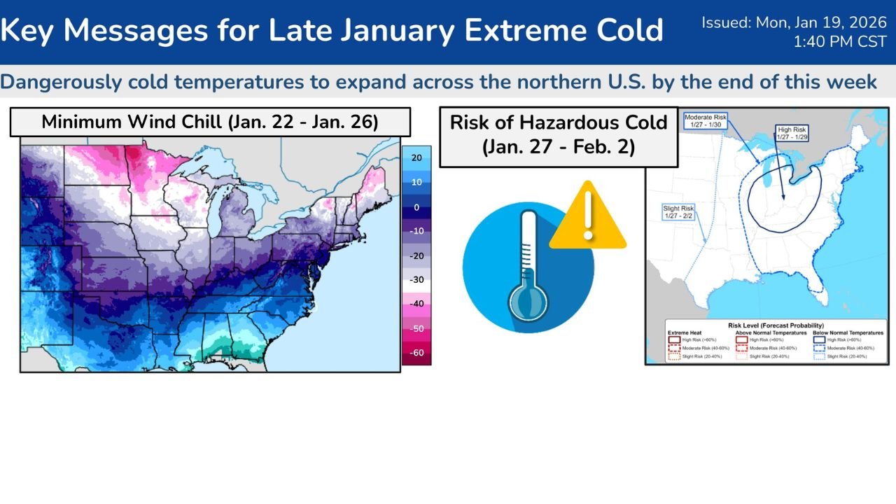
Arctic Air Sets the Stage for Dangerous Cold
Behind and north of the storm, Arctic air is expected to surge southward, bringing dangerously low wind chills to much of the Midwest, Great Lakes, and eventually the Northeast.
Forecast guidance indicates:
- Wind chills potentially dropping into the -30s to -50s across parts of the Upper Midwest
- Sub-zero temperatures expanding into the Ohio Valley and Northeast by Friday night
- Single-digit and teens possibly reaching into the southern Plains and Mid-South
This cold air mass is expected to be persistent, with well-below-normal temperatures lingering into late January and early February, especially across the Ohio Valley and central Appalachians.
Travel, Infrastructure, and Safety Concerns Growing
With snow and ice overlapping a surge of extreme cold, impacts could quickly escalate. Road conditions may deteriorate rapidly, especially during Friday night into Saturday, when precipitation rates could increase and surface temperatures drop further.
Key concerns include:
- Hazardous road travel and possible closures
- Ice-related power outages in parts of the South and Mid-South
- Increased risk of frostbite and hypothermia with prolonged exposure
Residents across the affected states are urged to monitor forecasts closely, review winter safety plans, and prepare for possible disruptions to travel, school schedules, and daily routines.
What to Watch Over the Next 48 Hours
While confidence is rising, some uncertainty remains regarding exact snowfall totals, ice placement, and how far south the coldest air penetrates. The next few forecast updates will be critical in refining impacts for individual cities and regions.
Even so, the overall signal is clear: a powerful winter storm combined with a significant Arctic outbreak is increasingly likely, and preparation time is narrowing.
As always, stay weather-aware, protect people, pets, pipes, and plants, and be ready to adjust plans as this high-impact late-January weather threat comes into focus.
For continued weather updates, safety tips, and how this system could affect upcoming events and travel plans, stay connected with ChicagoMusicGuide.com and join the conversation as conditions evolve.