
Texas, Oklahoma, Arkansas, Tennessee, Kentucky, Virginia and the Mid-Atlantic Face Potential Major Winter Storm With Snow, Ice and Arctic Cold Late This Week
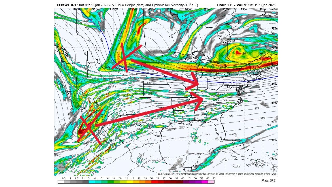
UNITED STATES — Forecast confidence is gradually increasing that a large, high-impact winter storm could develop late this week and intensify into the weekend, affecting a wide swath of the central and eastern United States. Latest guidance from NOAA, ECMWF (EURO), GFS, and multi-model ensemble data points to a setup capable of producing heavy snow north of the storm track, significant ice south of it, and a surge of Arctic air behind the system.
While exact details are still evolving, meteorologists agree the overall pattern is becoming increasingly favorable for a classic winter storm scenario across the Southern Plains, Mid-South, Appalachians, and Mid-Atlantic.
Why Forecasters Are Watching This System Closely
Several large-scale atmospheric signals are aligning:
- Phasing of the northern and southern jet streams, allowing energy to consolidate into a stronger storm
- Deep Gulf moisture feeding into the system as it tracks northeast
- Strong high pressure diving south from Canada, delivering sub-freezing air into regions that don’t often see prolonged cold
This combination dramatically raises the potential for widespread winter weather impacts, even if the storm track shifts slightly north or south.
What the Latest Data Shows Right Now
Current probabilistic maps highlight a broad corridor with elevated odds of accumulating snow and ice:
- Texas and Oklahoma: Increasing signals for wintry precipitation late Friday into Saturday, especially across North and Central Texas and southern Oklahoma, where ice could become a primary concern.
- Arkansas and Tennessee: High probabilities for accumulating snow, with some ensemble guidance showing a heavy snow swath setting up near or just north of the Tennessee Valley.
- Kentucky and West Virginia: Strong signals for impactful snow, especially if the low tracks along the Ohio or Tennessee Valley.
- Virginia, Maryland, Pennsylvania, and New Jersey: Some of the highest probabilities for at least 3 inches of snow, with localized chances exceeding 80–90% in parts of the Mid-Atlantic.
At the same time, areas south of the snow band—including parts of Texas, Louisiana, Mississippi, Alabama, and Georgia—could see freezing rain or sleet, depending on how quickly cold air deepens at the surface.
Snow vs. Ice: The Critical Uncertainty
One of the most important unresolved questions is where the rain-snow line ultimately sets up.
Small changes in:
- the strength of Arctic high pressure,
- the exact path of the surface low,
- or the timing of cold air arrival
could shift the heavy snow band north or south by 50–100 miles, dramatically changing local impacts.
This is why forecasters are emphasizing probabilities rather than exact snowfall totals at this stage.
Timing: When Impacts Could Begin
Based on current trends:
- Friday afternoon to Friday night: Storm begins organizing across Texas and the Deep South
- Saturday: Widespread winter weather expands northeast, with snow, sleet, and freezing rain becoming likely in multiple states
- Sunday: Storm exits the East Coast, followed by a strong Arctic blast pushing temperatures well below normal
Road conditions could deteriorate rapidly, particularly overnight when surface temperatures fall quickly.
Arctic Cold Behind the Storm
Regardless of precipitation type, very cold air is expected to spill southward behind the system:
- Sub-freezing temperatures may reach deep into Texas and the Gulf states
- Risk of frozen pipes, travel disruptions, and power strain increases
- Officials are urging residents to think about protecting the “4 P’s” — people, pets, pipes, and plants
Forecast Confidence and What to Do Now
Forecasters currently rate confidence at around 2.5 out of 5, meaning the threat is real but details are still being refined.
What you can do now:
- Monitor updated forecasts daily
- Avoid locking in travel plans for the weekend yet
- Prepare for the possibility of snow or ice even in areas that rarely see winter storms
- Have cold-weather supplies ready in case conditions worsen quickly
Why This Matters Even for Music Fans
For concert-goers and event planners, this storm could disrupt travel, cancel shows, and impact weekend events across multiple regions. Anyone planning to attend concerts, festivals, or performances late this week into the weekend should stay flexible and keep a close eye on local advisories.
As confidence increases and higher-resolution models come into range, clearer answers on who gets snow, who gets ice, and how severe impacts may be will emerge. Until then, this is a developing winter storm worth serious attention.
Stay tuned to ChicagoMusicGuide.com for continued weather updates and how this evolving winter threat could affect travel, events, and live music plans across the country.