
Texas, Oklahoma, Arkansas, Tennessee, Kentucky, Virginia, North Carolina and New Jersey Brace for Long-Duration Winter Storm With Heavy Snow, Ice and Dangerous Cold
UNITED STATES — A long-duration and increasingly high-impact winter storm is taking shape across a wide swath of the central and eastern United States, with forecast guidance now showing a prolonged period of heavy snow, significant ice accumulation, and dangerous cold stretching from the Texas Panhandle through the Mid-South, Appalachians, and into the Mid-Atlantic and Northeast between Friday, January 23 and Monday, January 26.
Latest model trends and national hazard outlooks show the storm has shifted slightly north, expanding the number of states likely to experience disruptive winter weather. The system is expected to unfold in multiple phases, prolonging impacts and increasing the risk of travel disruptions, power outages, and infrastructure strain across several regions.
Widespread Heavy Snow Expected From the Southern Plains to the Mid-Atlantic
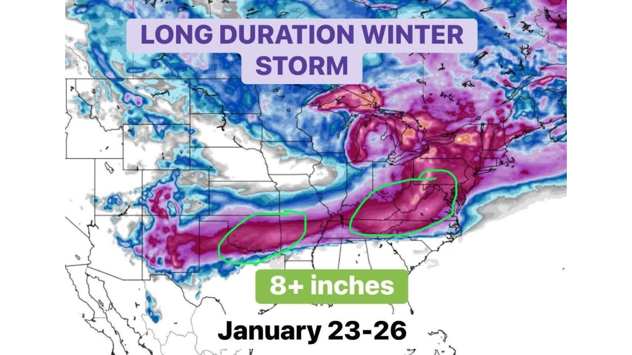
Forecast data indicates a long, continuous stripe of 6+ inches of snow developing from Oklahoma and northern Texas through Arkansas, Tennessee, Kentucky, Virginia, and into New Jersey. Some guidance highlights 8+ inch snowfall potential in portions of:
- Southern Oklahoma, including the Oklahoma City metro
- Eastern Tennessee and western North Carolina, especially higher elevations of the southern Appalachians
- Parts of Virginia, West Virginia, Pennsylvania, and New Jersey
While the GFS model is known to occasionally overestimate snowfall totals, its recent runs showing near-foot totals in central Oklahoma reinforce confidence that 6–10 inches is a reasonable expectation in several core impact zones, especially given the storm’s long duration rather than a single intense burst.
Snowfall is expected to begin Friday, intensify through the weekend, and linger into early Monday in some areas, particularly across the Mid-Atlantic and Northeast.
Dangerous Ice Corridor From Texas Through the Carolinas
South of the primary snow axis, a significant freezing rain and sleet zone is increasingly likely to develop. This ice corridor is forecast to extend from central and eastern Texas through parts of Arkansas, the Mid-South, and into the Carolinas.
Ice accumulation in this region raises concerns for:
- Widespread power outages
- Downed trees and power lines
- Extremely hazardous road conditions
- Long-lasting impacts due to cold air remaining in place after precipitation ends
The Weather Prediction Center’s hazards outlook shows freezing rain overlapping areas already under heavy snow threat, compounding risks for communities caught near the transition zone.
Extreme Cold and Dangerous Wind Chills Add to the Risk
Behind the storm system, hazardous cold air is expected to surge south and east, reinforcing icy conditions and prolonging impacts. Apparent temperature (wind chill) forecasts show single-digit and sub-zero values possible across parts of the Midwest, Mid-South, and interior Northeast.
This combination of snow, ice, and prolonged cold increases the danger for anyone without reliable heat, particularly if power outages become widespread. Officials continue to emphasize preparation now, before conditions deteriorate.
Travel Disruptions Likely From Friday Through Early Next Week
Confidence is increasing that major travel disruptions will develop beginning late Friday and continue through the weekend. Snow-covered roads, freezing rain, and low visibility could make travel dangerous or impossible at times across multiple interstate corridors.
Areas most at risk for prolonged impacts include:
- Northern and central Texas
- Oklahoma and Arkansas
- The Tennessee Valley
- The Appalachians
- The Mid-Atlantic and southern New England
Even locations that miss the heaviest snow totals may still experience delays due to ice, cold, or upstream transportation issues.
Forecast Confidence High, Exact Placement Still Uncertain
Meteorologists stress that while confidence is high that a significant winter storm will occur, exact snowfall and ice placement may continue to shift in the coming days. Small changes in storm track could move the heaviest snow or ice band north or south, especially near the transition zone.
Residents across the affected states are encouraged to monitor updates closely and prepare for a prolonged, multi-day winter weather event rather than a brief storm.
What You Should Do Now
- Plan ahead and be ready to adjust travel plans
- Protect people, pets, pipes, and plants
- Ensure you have multiple ways to receive weather alerts
- Prepare for possible power outages, especially in ice-prone areas
This system is shaping up to be one of the more expansive winter storms of the season, with impacts felt well beyond a single day or region.
For continued weather updates, regional impacts, and safety guidance, stay connected with ChicagoMusicGuide.com and check back as forecast details are refined.