
Texas, Oklahoma, Georgia, South Carolina and North Carolina Face Early April Heat Surge as Spring Pattern Shifts Toward Summer-Like Temperatures
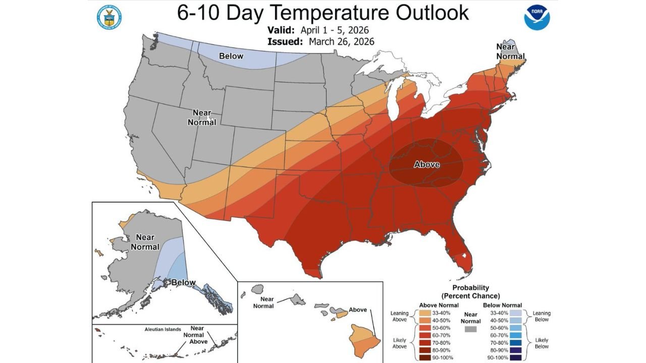
UNITED STATES — A major temperature shift across the Southern and Eastern United States is signaling an early arrival of summer-like warmth as April begins. According to the latest 6–10 day temperature outlook valid April 1–5, 2026, a broad region stretching from Texas and Oklahoma through Georgia, the Carolinas, and up into the Mid-Atlantic is expected to experience well above normal temperatures.
This pattern suggests that for many areas, spring may be short-lived, with conditions quickly turning warmer than average across a large portion of the country.
Widespread Above-Normal Temperatures Across the South and East
Forecast models highlight a large zone of above-normal temperatures covering much of the Southern Plains, Mississippi Valley, Southeast, and Mid-Atlantic regions. States including Texas, Oklahoma, Arkansas, Louisiana, Mississippi, Alabama, Georgia, South Carolina, and North Carolina are all expected to fall within the highest probability zone for warmer-than-average conditions.
The strongest signals for heat are centered across the Deep South and Southeast, where confidence is highest that temperatures will trend significantly above seasonal norms. This could lead to daytime highs pushing well into summer-like ranges, especially in areas already experiencing warm conditions heading into late March.
Even parts of the Midwest and Northeast, including states like Illinois, Indiana, and Pennsylvania, are expected to see above-normal readings, though the intensity of the warmth may be slightly lower compared to the southern states.
What’s Driving This Early April Heat Pattern
The developing pattern is tied to a large-scale atmospheric setup that favors warm air advection across the eastern half of the country. A ridge of high pressure is expected to dominate much of the region, allowing southerly winds to transport warm air northward.
This setup creates a classic early-season warm surge, where temperatures rise quickly over several days, especially when combined with strong sunshine and limited storm activity in some areas.
Meanwhile, parts of the western United States are expected to remain closer to near-normal or slightly below-normal temperatures, creating a sharp contrast between the western and eastern halves of the country.
Spring May Feel Short-Lived in Many States
One of the most notable aspects of this forecast is how quickly conditions are transitioning. Many areas that typically experience mild spring weather in early April could instead see temperatures more typical of late spring or even early summer.
This rapid shift can impact everything from energy demand to outdoor activities, as residents adjust to warmer conditions earlier than usual. For cities across the Southeast and Southern Plains, this could mean the first extended stretch of warm weather in 2026.
The phrase “skipping spring and jumping into summer” reflects how abrupt this change may feel for many communities across the region.
What to Expect Moving Forward
While this warm pattern is expected to dominate the early part of April, it may also set the stage for increased storm activity later in the month, as warm air interacts with incoming systems from the west.
For now, the focus remains on the significant temperature anomaly, which could last several days and impact a wide swath of the country.
Residents across Texas, Oklahoma, Georgia, the Carolinas, and neighboring states should prepare for unseasonably warm conditions, stay hydrated, and remain aware of any changes in the forecast.
For more updates on national weather trends, seasonal outlooks, and regional forecasts, visit ChicagoMusicGuide.com for the latest coverage.