
Texas, Oklahoma, Kansas and Missouri in Focus March 10–11 as Powerful Rockies Trough and Intense Wind Shear Raise Severe Storm Concerns
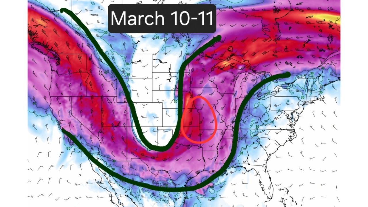
UNITED STATES — A potent upper-level setup is drawing increasing attention for March 10–11, with a deep trough carving into the western United States and powerful wind shear spreading across the Plains and into the Midwest.
Forecast guidance shows a classic early-spring severe weather pattern beginning to organize — particularly from Texas northward into Oklahoma, Kansas and possibly Missouri.
Deep Western Trough Sets the Stage
Upper-level maps depict a pronounced trough digging southward along the West Coast before swinging into the Desert Southwest and southern Rockies.
This configuration typically:
- Strengthens mid-level winds across the southern Plains
- Enhances upper-level divergence
- Supports large-scale lift east of the trough axis
The strongest wind energy appears arcing from California and Nevada into Arizona and New Mexico, then ejecting into the central Plains.
Strong Shear Spreads into the Plains
As the trough ejects, deep-layer wind shear increases dramatically across:
- Texas
- Oklahoma
- Kansas
- Missouri
- Portions of Arkansas
Wind barbs across the region indicate a strong southwesterly flow aloft, overlapping with surface-level moisture return from the Gulf.
This combination of:
- Strengthening jet stream winds
- Increasing low-level flow
- Surface destabilization
is often associated with organized thunderstorm development.
Missouri and Kansas in a Notable Zone
The central Plains into western Missouri stand out as a corridor where upper-level energy overlaps with strong shear.
Cities in or near the highlighted zone include:
- Wichita, Kansas
- Topeka, Kansas
- Kansas City, Missouri
- Springfield, Missouri
This does not guarantee severe weather, but the environmental ingredients appear favorable for organized storms if instability materializes.
Midwest Also Watching
As the trough lifts northeast, wind energy spreads into:
- Iowa
- Illinois
- Parts of the Upper Midwest
While moisture quality will determine how far north the severe threat extends, Illinois and surrounding states should monitor trends closely as we move closer to the event window.
What Makes This Setup Concerning
Key ingredients appearing in guidance include:
- A deep, negatively tilted trough potential
- Strong 500mb wind speeds
- Expanding deep-layer shear
- Plains-focused jet streak energy
When these ingredients align during March, severe storms can develop rapidly across the southern and central Plains.
Still Several Days Out
It is important to stress that this is still a developing signal.
Details that remain uncertain include:
- Exact storm initiation zones
- Degree of surface instability
- Quality of Gulf moisture return
- Timing of the trough ejection
However, the upper-level pattern and shear setup are strong enough to warrant attention.
Bottom Line
March 10–11 is emerging as a timeframe to monitor for potential severe weather across Texas, Oklahoma, Kansas and Missouri — with the possibility of impacts expanding toward Illinois and the Midwest depending on how moisture and instability evolve.
As we move closer, forecast clarity will improve.
Stay with ChicagoMusicGuide.com for continued updates as this early-March severe weather setup develops across the Plains and Midwest.