
Texas Panhandle Faces Dangerous Sub-Zero Wind Chills Tonight Through Saturday Morning, Values Drop Near -20°F
TEXAS — The Texas Panhandle is under dangerously cold conditions Friday night into early Saturday, as Arctic air combined with strong winds pushes wind chill values into the -10°F to -20°F range, according to National Weather Service data from Amarillo.
The coldest conditions are expected late Friday night through Saturday morning, when exposure outdoors can quickly become life-threatening without proper protection.
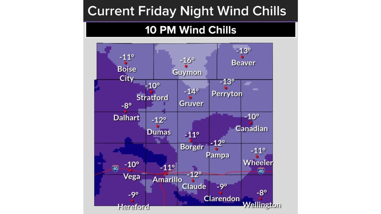
What the Wind Chill Map Shows Right Now (10 PM Friday)
Based on the latest Friday night wind chill map, much of the Texas Panhandle is already experiencing sub-zero feels-like temperatures, with colder values expected to intensify overnight.
Key observed wind chills around 10 PM include:
- Guymon, OK: around -16°F
- Gruver, TX: near -14°F
- Perryton, TX: around -13°F
- Beaver, OK: near -13°F
- Borger & Pampa, TX: around -11°F to -12°F
- Amarillo, TX: near -11°F
- Canadian, TX: around -10°F
- Dalhart & Dumas, TX: around -10°F to -12°F
These values are expected to drop further overnight, with some locations briefly approaching -20°F wind chills before sunrise Saturday.
Why Conditions Are Especially Dangerous Tonight
The danger isn’t just the cold temperature — it’s the wind.
Strong northerly winds are stripping heat from exposed skin extremely fast, making it feel far colder than the actual air temperature. Under these conditions:
- Frostbite can begin in 15–30 minutes
- Hypothermia risk rises rapidly
- Any outdoor activity becomes dangerous without layered protection
Wind chills this low are rare for the Texas Panhandle and meet criteria for dangerous cold exposure, especially for those without adequate shelter.
Expected Timeline
- Friday Evening: Wind chills already below zero
- Late Friday Night: Cold intensifies, worst conditions develop
- Early Saturday Morning: Wind chills approach -20°F in some areas
- Saturday Mid-Morning: Gradual improvement as winds ease and temperatures recover slightly
Safety Actions Strongly Recommended
Residents across the Texas Panhandle should take immediate precautions:
- Limit time outdoors to only what is absolutely necessary
- Cover all exposed skin — face, hands, ears are most vulnerable
- Dress in multiple insulating layers
- Bring pets indoors — animals are highly vulnerable to wind chills
- Check on elderly neighbors and those without reliable heating
Travel is not advised overnight unless necessary, as vehicles can fail quickly in extreme cold.
Why This Matters for the Region
While snow and ice often grab attention, wind chill is one of the deadliest winter hazards. Even without falling snow, exposure to temperatures this extreme can be fatal.
This cold snap represents one of the harshest Arctic intrusions of the season for the Texas Panhandle, and impacts will be felt until conditions ease later Saturday.
Stay weather-aware and take cold safety seriously.
For continued weather updates, alerts, and regional impact coverage, keep following ChicagoMusicGuide.com.