
The Midwest and East Are Already Leading the Entire United States in Severe Thunderstorm Watches for 2026 With Illinois, Indiana and Michigan Topping the National Count Just Three Months Into the Year
CHICAGO, IL — Three months into 2026 and the numbers are already telling a story that anyone living between the Mississippi River and the East Coast can feel in their bones: this year has been relentlessly active for severe weather, and the data now confirms it in black and white. The Midwest and eastern United States are leading the entire nation in Severe Thunderstorm Watches issued so far in 2026, with the corridor centered on northern Illinois, Indiana, and Michigan sitting at the very top of the national count.
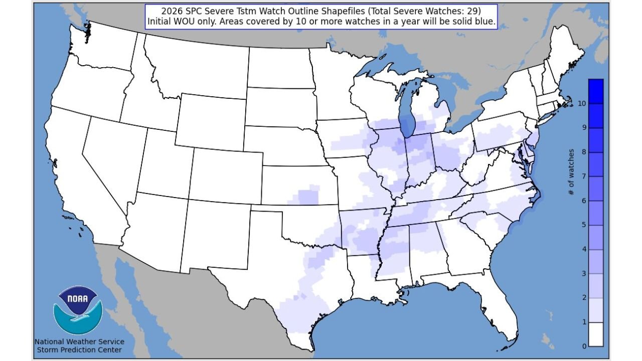
The total number of Severe Thunderstorm Watches issued across the United States so far in 2026 stands at 29 — and the distribution of where those watches have fallen is striking. The entire western half of the country shows virtually zero watch activity. Every significant watch corridor is concentrated east of the Mississippi River, with the highest densities in the Great Lakes states and the Ohio Valley.
What a Severe Thunderstorm Watch Means and Why the Count Matters
A Severe Thunderstorm Watch is issued by the Storm Prediction Center when atmospheric conditions are favorable for the development of severe thunderstorms — defined as storms producing winds of 58 mph or greater, hail one inch or larger in diameter, or tornadoes — across a broad geographic area. Watches are distinct from Warnings: a Watch means conditions are right for severe weather to develop, while a Warning means it is actively occurring.
When a single area accumulates 10 or more Severe Thunderstorm Watches in a single calendar year, it enters the highest tier on the SPC tracking map — depicted in solid blue. That threshold has already been reached across portions of northern Illinois and Indiana with three full months of the severe weather season still ahead.
The significance of hitting that marker before April is not lost on forecasters. The peak of severe weather season across the Midwest and Great Lakes typically runs from April through June. The fact that the 10-watch threshold has already been crossed in parts of Illinois and Indiana before that window has even opened suggests 2026 is tracking toward an unusually active severe weather year for the region.
Where the Watches Have Concentrated: A State-by-State Breakdown
The SPC watch map for 2026 through March 31 shows a clear and dramatic east-west divide. Every state west of the Mississippi River — the entire mountain west, the Pacific Coast, the Great Plains — shows little to no Severe Thunderstorm Watch activity. The action has been almost entirely confined to the eastern tier of the nation.
2026 Severe Thunderstorm Watch Count by Region
| Watch Count | States/Regions |
|---|---|
| 10+ (Solid Blue — National High) | Northern Illinois, Indiana, Lower Michigan |
| 8 to 9 | Ohio, Illinois core, western Pennsylvania |
| 6 to 7 | Kentucky, Tennessee, Virginia, West Virginia, Maryland/Delaware |
| 4 to 5 | Missouri, Arkansas, Mississippi, Alabama, Georgia, Carolinas, New Jersey, New York |
| 2 to 3 | Louisiana, Florida, Iowa, Wisconsin fringe, Connecticut, Rhode Island |
| 0 to 1 | All western states — zero to near-zero watch activity |
State-by-State 2026 Watch Activity
🔵 Illinois (Northern) and Indiana — National leaders. The northern Illinois and Indiana corridor has already hit the 10-watch threshold, placing it in the highest tier on the national tracking map. This zone, which includes the Chicago metro and northwest Indiana, has been under Severe Thunderstorm Watch conditions more times in the first three months of 2026 than most of the country sees in an entire year.
🔵 Michigan (Lower Peninsula) — Tied for the national lead. Lower Michigan sits inside the solid blue zone alongside northern Illinois and Indiana, reflecting the active storm track that has repeatedly pushed through the Great Lakes region in early 2026.
🔴 Ohio and Western Pennsylvania — High activity. With 8 to 9 watches already issued, Ohio ranks among the most active states in the nation for 2026 severe weather watch coverage. The Ohio Valley has been a repeated target for organized severe storm systems tracking northeast from the Mississippi Valley.
🟠 Kentucky, Tennessee, Virginia and West Virginia — Elevated activity. The Ohio Valley and Appalachian corridor states have accumulated 6 to 7 watches each through March. This reflects the persistent southwesterly storm track that has funneled severe weather from the Plains into the mid-South and Appalachian region throughout early 2026.
🟠 Missouri, Arkansas, Mississippi, Alabama, Georgia and the Carolinas — Above average activity. Each of these states has recorded 4 to 5 Severe Thunderstorm Watches in the first quarter of 2026 alone. The Mississippi River corridor has been one of the most consistently active severe weather pathways of the year.
🟡 Louisiana, Florida, Iowa, New York and New Jersey — Moderate activity. These states have recorded 2 to 3 watches each, reflecting their position on the edges of the primary storm corridors that have dominated the 2026 severe weather pattern so far.
🟢 All Western States — Near zero activity. California, Oregon, Washington, Nevada, Utah, Colorado, Wyoming, Montana, Idaho, New Mexico, Arizona, and the Dakotas have recorded little to no Severe Thunderstorm Watch coverage in 2026. The severe weather pattern has been almost entirely absent from the western United States through the first three months of the year.
What This Means Going Forward
The 2026 severe weather season is still in its early stages. The peak tornado and severe thunderstorm season for the Midwest and Great Lakes runs from April through June, meaning the states that are already leading the national watch count are now entering the most dangerous stretch of the calendar year with momentum already building.
For Illinois, Indiana, Michigan, and Ohio in particular, the combination of an already-elevated watch count and the approach of peak severe weather season means residents should treat spring 2026 weather awareness as a priority — not a background concern.
Forecast Confidence: Confirmed Data. The watch counts presented here are official historical records from the Storm Prediction Center, not forecasts. The numbers through March 31, 2026 are final and verified. The outlook for continued above-normal severe weather activity across the Midwest and eastern United States through spring remains consistent with the pattern already established in the first quarter of the year.
More severe weather records and pattern analysis are always on the horizon. Stay informed at ChicagoMusicGuide.com — your source for severe thunderstorm tracking, watch and warning coverage across Illinois, Indiana, Michigan, and the entire United States.