
Tornado Probabilities Upgraded in Southern Missouri as Supercell Storms Organize Across the Ozarks and Red River Region
SPRINGFIELD, MISSOURI — The Storm Prediction Center (SPC) has upgraded tornado probabilities across southern Missouri as a cluster of supercell thunderstorms begins organizing across the Ozarks, signaling a growing severe weather threat stretching across parts of the Lower Mississippi Valley and into portions of the Ohio Valley.
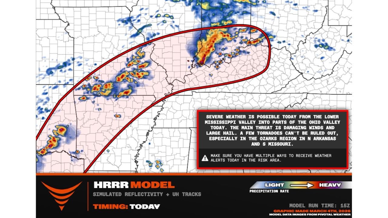
Meteorologists say the evolving storm system could produce damaging winds, large hail, and a few tornadoes, particularly in areas of northern Arkansas and southern Missouri, where atmospheric conditions appear most favorable for organized severe thunderstorms.
The updated outlook comes as radar and high-resolution forecast models show storms intensifying and moving northeast across the region, prompting forecasters to closely monitor the developing weather situation.
Supercells Target the Ozarks Region in Missouri and Arkansas
Forecasters say the Ozarks region, including southern Missouri and northern Arkansas, is currently the most likely location for supercell development capable of producing tornadoes.
Cities such as Springfield, Missouri; Branson, Missouri; and Harrison, Arkansas sit near the corridor where storms are beginning to organize. Meteorologists note that isolated supercells within this cluster could rotate strongly, increasing the risk for brief tornadoes and large hail.
The primary severe weather threats expected across the region include:
- Damaging wind gusts
- Large hail
- Isolated tornadoes
The Storm Prediction Center warns that a few tornadoes cannot be ruled out, especially as storms strengthen while moving through the Ozarks terrain.
Red River Region of Oklahoma and Texas Also Under Watch
Meteorologists are also closely monitoring conditions along the Red River region of southeastern Oklahoma into northeastern Texas, where additional supercell thunderstorms are expected to mature during the late afternoon hours.
Forecast models indicate storms could intensify between 4 PM and 5 PM, supported by dew points reaching the mid to upper 60s, which provide the moisture needed for strong thunderstorm development.
Areas within this corridor include cities such as:
- Durant, Oklahoma
- Paris, Texas
- Sherman, Texas
- Texarkana, Texas
If storms remain isolated in this region, meteorologists say they could quickly strengthen into supercells capable of producing large hail, damaging winds, and possible tornadoes.
Severe Weather Risk Extends Toward the Ohio Valley
Beyond the Ozarks, the severe weather threat stretches northeast into portions of the Lower Mississippi Valley and parts of the Ohio Valley, where storms may continue tracking through the evening.
Although the environment becomes somewhat less favorable farther northeast, strong thunderstorms could still produce damaging winds and hail across portions of the region.
Meteorologists say this expanding storm corridor highlights the dynamic nature of the system moving across the central United States, where strong atmospheric energy is fueling widespread thunderstorm development.
Meteorologists Urge Residents to Stay Alert
Weather experts emphasize that severe storms can develop rapidly in these environments, especially when supercells form ahead of larger storm clusters.
Because of the upgraded tornado probabilities and ongoing storm development, residents in Missouri, Arkansas, Oklahoma, and Texas are urged to monitor weather alerts and warnings throughout the day.
Forecasters recommend having multiple ways to receive weather notifications, including weather apps, emergency alerts, and local forecasts.
As the storm system continues to evolve, additional severe thunderstorm watches or tornado warnings may be issued depending on how storms intensify across the region.
For ongoing coverage of major weather events, storm forecasts, and regional weather updates across the United States, continue following the latest reports at ChicagoMusicGuide.com.