
Tornado Risk Expands From Kansas Through Oklahoma and North Texas as Meteorologists Monitor Three Potential Supercell Zones
WICHITA, KANSAS — A highly conditional severe weather setup is unfolding across parts of the Central Plains and Southern Plains, with meteorologists closely monitoring Kansas, Nebraska, Iowa, Oklahoma, and North Texas for the potential development of isolated supercells capable of producing tornadoes. While uncertainty remains regarding exactly where storms will develop, forecasters warn that any storm able to remain isolated could rapidly intensify and produce large hail, damaging winds, and possibly strong tornadoes.
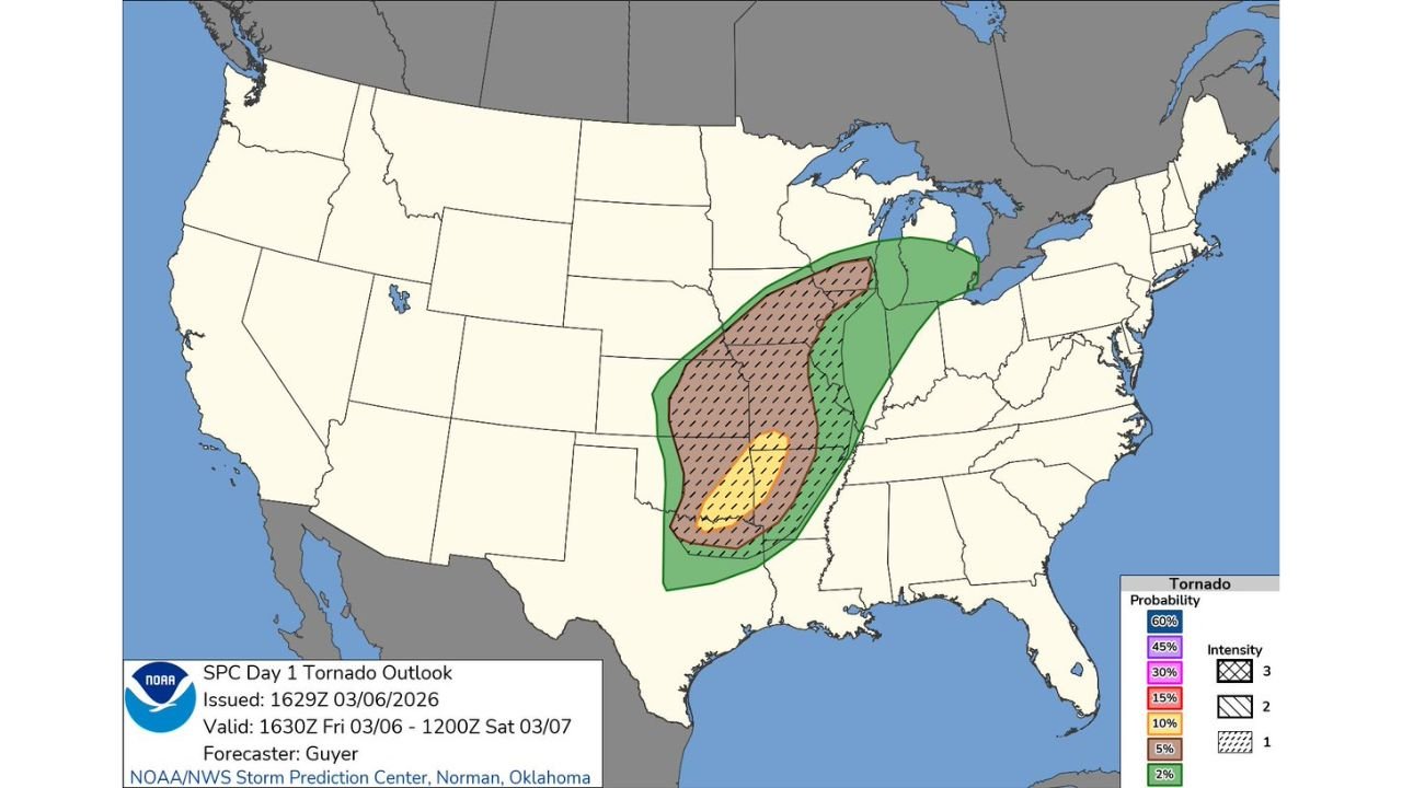
Weather outlook data issued by the NOAA Storm Prediction Center highlights a broad corridor of severe weather potential stretching from Texas northward through Oklahoma and Kansas into Iowa and parts of the Midwest. Within that area, meteorologists are focusing on three specific regions where atmospheric conditions may allow storms to organize into dangerous supercells.
Northern Target Zone From Northeast Kansas to Southeast Nebraska and Iowa
The first area forecasters are monitoring stretches from northeast Kansas through southeast Nebraska and into parts of western Iowa. This region lies within a corridor where instability and strong wind shear could allow thunderstorms to quickly organize into rotating supercells during the afternoon and evening hours.
Cities such as Topeka, Manhattan, and Kansas City in Kansas, along with Lincoln in Nebraska and parts of western Iowa, may see storms initiate that could produce large hail, damaging winds, and possible tornadoes before transitioning into a more organized line of storms.
Meteorologists say storms in this northern region may begin as discrete supercells, which are capable of producing multiple severe hazards, but could later merge into a linear wind-producing system as the evening progresses.
Dryline Supercell Risk Along the I-35 Corridor From Wichita to Oklahoma City
A second area of concern lies farther south across eastern Kansas and northeast Oklahoma, particularly along the Interstate 35 corridor stretching from Wichita, Kansas to Oklahoma City, Oklahoma.
This region is expected to see a conditional dryline setup, where a boundary separating moist and dry air could trigger isolated thunderstorms. If storms form in this environment and remain discrete rather than merging into clusters, meteorologists warn that supercells capable of producing strong tornadoes could develop.
The potential tornado risk in this zone could extend eastward into western Missouri and northwest Arkansas, depending on how storms evolve later in the day. Even a single isolated storm in the right atmospheric environment could become severe quickly.
Southeast Oklahoma and North Texas Also Under Watch
The third area being closely monitored extends across southeast Oklahoma into parts of North Texas, particularly east of the Interstate 35 corridor. Forecast models indicate that storms in this region may develop in a more complex and messy storm environment, which can sometimes limit tornado potential.
However, meteorologists emphasize that any supercell that manages to remain isolated could still produce a significant tornado. Cities such as Durant, Ardmore, Sherman, and other communities near the Oklahoma–Texas border may be near this conditional severe weather zone.
Even if storms do not become widespread, forecasters stress that individual storms could become dangerous quickly, especially if atmospheric conditions allow a storm to strengthen before merging with surrounding activity.
Residents across Kansas, Nebraska, Iowa, Oklahoma, and North Texas are being urged to remain weather-aware throughout the day as the severe weather setup evolves. Meteorologists say the environment contains the ingredients necessary for rapid storm intensification if thunderstorms form in the right locations.
As forecasters continue analyzing radar trends, atmospheric data, and new model guidance, updates on the evolving Central Plains severe weather threat will continue. For ongoing coverage of severe storms, tornado threats, and major weather developments across the United States, visit ChicagoMusicGuide.com.