
Tornado Threat Increases Across Kansas and Nebraska This Afternoon as a Dangerous Rotating Storm System Puts Omaha, Wichita and Kansas City on Alert for Strong Tornadoes Through This Evening
OMAHA, NE — The tornado threat across Kansas and Nebraska has increased sharply this afternoon, and the atmospheric setup now in place is serious enough that forecasters are tracking the potential for a strong tornado before the evening is over. A remnant mesoscale convective vortex — a rotating low-pressure system that survives after a cluster of thunderstorms breaks down, capable of triggering new and dangerous rotating storms when conditions align — is the primary driver of the elevated threat across the region today.
What Is Driving the Increased Threat
Current analysis indicates the remnant circulation is positioned over the Nebraska and Kansas corridor, and the environment around it has become favorable enough through Saturday afternoon to support tornado development. A mesoscale convective vortex, often abbreviated as an MCV, is not always a well-known phenomenon outside the meteorological community, but it deserves serious attention. When one of these circulations moves into an unstable, shear-rich environment — exactly the kind of setup present today — it can trigger rotating thunderstorms capable of producing tornadoes with relatively little warning time compared to a classic supercell outbreak.
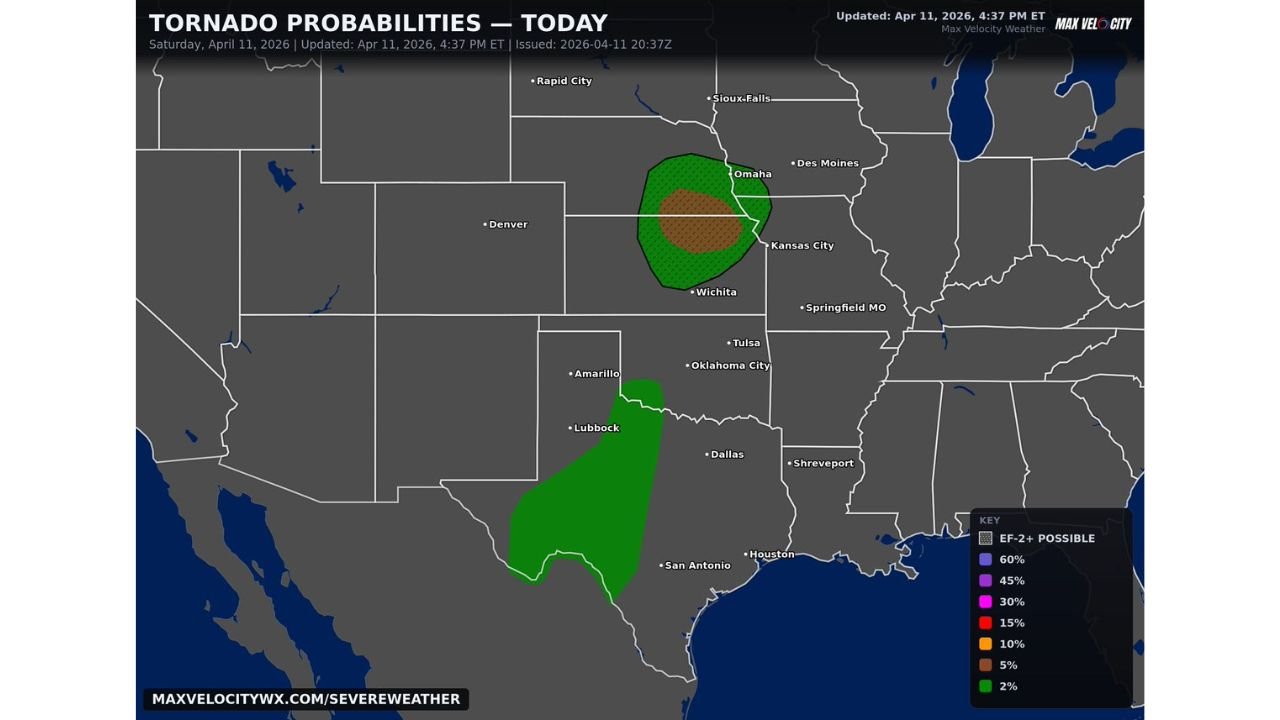
The tornado probability map issued Saturday, April 11, 2026, shows the highest concentration of risk centered directly over the Omaha, Nebraska and Kansas City corridor, with elevated probabilities extending southward into central Kansas near Wichita.
Tornado Probability Breakdown
| Probability Zone | Level | Primary Cities in Zone |
|---|---|---|
| Brown Core | 5% tornado probability, EF-2+ possible | Omaha, Nebraska and Kansas City corridor |
| Green Inner Ring | 2 to 5% tornado probability | Wichita, Kansas and surrounding areas |
| Green Outer Zone | 2% tornado probability | Broader Nebraska and Kansas fringe |
| Southern Texas Zone | 2% tornado probability | West and Central Texas, San Antonio fringe |
The brown shaded core centered near Omaha and extending toward Kansas City carries both a measurable tornado probability and an EF-2 or stronger tornado designation — meaning forecasters cannot rule out a significant, destructive tornado within this zone today. An EF-2 tornado produces winds of 111 to 135 mph, strong enough to destroy manufactured homes, snap large trees, and cause catastrophic damage to poorly constructed structures.
State-by-State Threat Assessment
Nebraska — Omaha and Eastern Nebraska The bullseye of today’s tornado probability sits directly over eastern Nebraska, with Omaha at the center of both the highest probability zone and the EF-2 or stronger designation. Residents across Omaha and surrounding eastern Nebraska communities face the most elevated tornado risk of anyone in the current outlook. Storm development this afternoon and evening should be monitored continuously.
Kansas — Wichita and Kansas City Corridor Kansas carries elevated tornado probabilities across a broad north-south corridor today. Wichita sits within the inner green probability ring, while the Kansas City metro area on the Missouri border falls within the highest-risk brown core zone. Both cities should treat this afternoon and evening as an active weather watch situation.
Texas — West and Central Texas Including San Antonio Fringe A separate and distinct tornado probability zone is mapped across west and central Texas, extending from near Lubbock southward through the San Antonio fringe. This zone carries a 2% tornado probability and is disconnected from the primary Nebraska and Kansas corridor. The threat here is lower but not zero, and residents across west Texas should remain weather-aware through the evening hours.
Forecast Confidence
Forecast Confidence: Moderate. The remnant circulation driving today’s threat is a real and confirmed feature on current analysis. The uncertainty lies in exactly how aggressively new storm development fires along and near the circulation this afternoon, and whether individual storms can sustain the rotation needed to produce tornadoes before the evening destabilization window closes. The EF-2 or stronger designation on the Omaha and Kansas City core zone signals that forecasters consider a significant tornado outcome realistic if storm mode evolves unfavorably. All residents across eastern Nebraska, central and northern Kansas, and the Kansas City metro should have a weather alert source active and a shelter plan ready for this afternoon and evening.
More tornado threat and severe storm coverage is always on the horizon. Stay informed at ChicagoMusicGuide.com — your source for tornado probability tracking across Nebraska, Kansas, and the entire United States.