
Tuesday Storms Are Already Firing Across Chicago and Detroit While Isolated Severe Cells Could Develop Ahead of the Main Wave Across Indiana, Ohio and Kentucky This Afternoon
CHICAGO, IL — Tuesday’s severe weather event is not waiting around. As of 2:00 PM EDT on March 31st, the latest high-resolution model data is showing active storm cells already firing along the Chicago to Detroit corridor — with a low pressure center tracking at 999 mb near Milwaukee driving the entire system northeast through the Great Lakes. But there is a secondary question now emerging that could significantly impact how Wednesday’s severe weather day sets up across the central Plains and Midwest — and it starts with what happens in the next few hours across Indiana, Ohio and Kentucky.
What Is Happening Right Now: The Main Storm Line
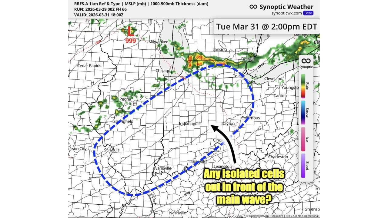
The RRFS-A 1km high-resolution model, run from 00z March 29 and valid at 18:00z March 31 — 2:00 PM EDT Tuesday — is showing a well-organized line of precipitation stretching from Chicago northeast through the southern Michigan corridor toward Detroit and Lansing. The heaviest and most intense rain and storm activity on this model frame is concentrated in the Chicago to Detroit corridor, with orange and red reflectivity values indicating the strongest cells in the line.
A surface low pressure center at 999 mb is positioned near Milwaukee, driving the storm system northeast. At 999 mb, this is a moderately strong surface low for late March — strong enough to support organized severe weather along and ahead of its associated frontal boundaries as it tracks through the Great Lakes.
The storm line itself is currently producing a mix of rain and embedded thunderstorms along the Chicago to Toledo to Detroit corridor — exactly where the Slight Risk zone flagged for Tuesday’s event is most concentrated.
The Critical Question for This Afternoon: Isolated Cells Ahead of the Wave
Here is where Tuesday’s event gets more complex — and more important to understand for anyone living across Indiana, Ohio and Kentucky between now and this evening.
The blue dashed circle on the model map highlights a zone covering Indianapolis, Dayton, Cincinnati, Columbus, Louisville and Lexington — the area south and east of the main storm line where the atmosphere has not yet been disturbed by the approaching frontal system. The annotation on the map asks exactly the right question: “Any isolated cells out in front of the main wave?”
This is the wild card of Tuesday’s severe weather setup. In certain atmospheric configurations, isolated supercell thunderstorms can develop ahead of the main frontal line in the warm sector — the zone of warm, moist and unstable air sitting south of the front. These discrete cells, separated from the main squall line, often have access to the most favorable wind shear and instability in the entire storm environment. That combination makes them disproportionately capable of producing tornadoes and large hail compared to storms embedded within the main line itself.
Whether these isolated cells develop this afternoon depends on several factors still being resolved — including how quickly cloud cover erodes south of the front, how much surface heating occurs across Indiana and Ohio, and whether any boundaries left over from earlier storm activity can serve as focal points for new development.
The afternoon hours from roughly 2:00 PM to 7:00 PM EDT are the window to watch most closely for any isolated severe cell development across this zone.
Why Monday Night Storms Matter for Wednesday
There is a longer-range implication buried in this Tuesday afternoon data that connects directly to the Wednesday April 1st severe weather setup flagged earlier across Oklahoma and Kansas.
How many storms develop Monday night and Tuesday across the Midwest will directly influence the number and placement of outflow boundaries across the central Plains ahead of Wednesday’s system. Outflow boundaries are essentially invisible highways left behind on the surface by dying storm systems — zones where the wind shifts, temperature drops slightly and the atmosphere is primed for new storm development.
In a high-CAPE environment like what is being modeled for Wednesday across Oklahoma and Kansas, outflow boundaries from Tuesday’s storms can serve as the triggering mechanism that fires isolated, tornado-capable supercells hours before the main Wednesday system arrives. This is one of the reasons why Wednesday’s tornado probability was higher than Friday’s in the latest outlook data — the Tuesday storm activity across the Midwest is essentially pre-loading the Wednesday severe weather environment.
Tuesday Afternoon Severe Weather Summary Table
| Zone | Current Status | Afternoon Threat | Timing | Confidence |
|---|---|---|---|---|
| Chicago to Detroit Corridor | 🔴 Active storms firing | Damaging winds, hail | Now through evening | 🔴 High |
| Milwaukee area | 🔴 Near surface low 999mb | Heavy rain, embedded thunder | Ongoing | 🔴 High |
| Indianapolis, Dayton, Columbus | 🟡 Warm sector — watching | Isolated severe cells possible | 2 PM – 7 PM EDT | 🟡 Low-Moderate |
| Cincinnati, Louisville, Lexington | 🟡 Warm sector — watching | Isolated supercell possible | Afternoon hours | 🟡 Low-Moderate |
| Wednesday Plains Setup | Depends on Tuesday storm count | Outflow boundary placement | Wed afternoon | 🟠 Moderate |
Where Each Area Stands Right Now
🔴 Chicago, Illinois and northern Indiana — Active storm line ongoing. The heaviest and most intense activity of Tuesday’s event is currently concentrated along this corridor. If you are in the Chicago metro or northwest Indiana right now, treat this as an active severe weather situation. Severe Thunderstorm Warnings are possible or already issued for portions of this zone.
🔴 Detroit and southeastern Michigan — The storm line is tracking directly toward the Detroit metro as of this model frame. Detroit, Toledo and the I-75 corridor should expect the main storm activity to arrive within the next one to two hours from this data valid time.
🟡 Indianapolis, Dayton and Columbus — Currently in the warm sector ahead of the main storm line. This is the zone meteorologists are watching most closely for isolated severe cell development this afternoon. If cloud cover erodes and surface temperatures rise even briefly across central Indiana and Ohio, the instability available in this zone is sufficient to support a severe thunderstorm or isolated tornado with any storm that manages to initiate.
🟡 Cincinnati, Louisville and Lexington — Southern fringe of the afternoon monitoring zone. Isolated storm development is possible here as well — particularly if an outflow boundary from earlier storm activity creates a focal point for new convection across the Ohio Valley.
🟢 Nashville and central Tennessee — South of the primary warm sector zone for Tuesday’s event. Storm threat is lower across this area for Tuesday afternoon and evening.
What to Do Right Now If You Are in the Risk Zone
Chicago, Detroit and the northern tier — This is an active situation. Weather alerts should already be on and active. If a Severe Thunderstorm Warning is issued for your county, move away from windows and stay indoors until the warning expires.
Indianapolis, Dayton, Columbus, Cincinnati — Keep a very close eye on conditions this afternoon. The isolated cell threat in this zone is real enough to take seriously even though it carries lower confidence than the main storm line to the north. If storms begin popping in your area before the main frontal line arrives, treat them as potentially severe until told otherwise. Do not assume a storm that develops in the warm sector ahead of a front is just a routine afternoon shower.
Tuesday Is Just the Opening Act — Wednesday and Thursday Bring Even Higher Tornado Potential Across the Plains and Midwest
Three consecutive days of severe weather are unfolding right now. Stay informed at ChicagoMusicGuide.com — your source for real-time storm tracking, isolated cell alerts and multi-day outbreak coverage across Chicago, Detroit, Indianapolis, Columbus and the entire United States.