
United States Faces Unseasonably Warm Christmas as Strong Ridge Drives Temperatures Well Above Normal
UNITED STATES — Much of the United States is on track for an unusually warm Christmas period as a powerful upper-level ridge expands across the country, driving temperatures well above seasonal averages and limiting cold air intrusions heading into the holiday week, according to long-range model guidance.
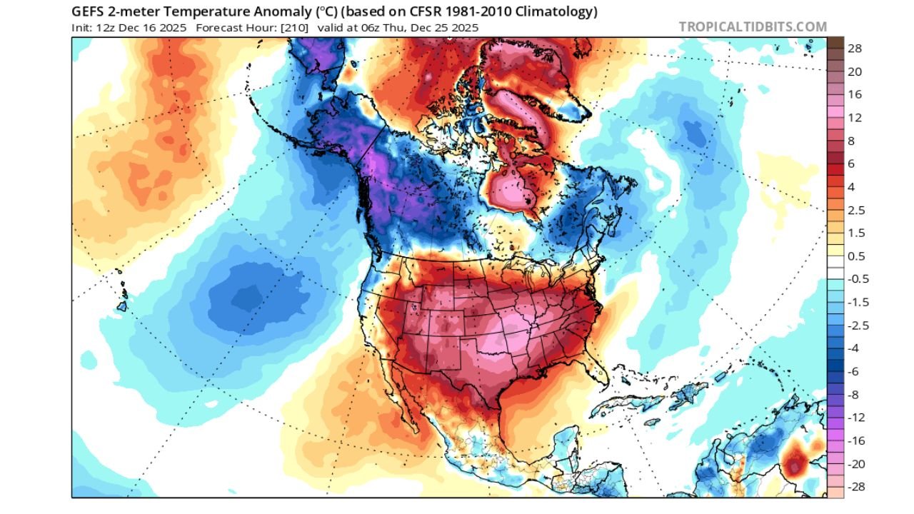
Forecast data shows widespread positive temperature anomalies across the central and eastern United States around December 25, with some regions experiencing conditions warm enough to feel more like early fall than late December.
Strong Upper-Level Ridge Dominates the Pattern
Model imagery analyzing 500mb geopotential height anomalies shows a pronounced ridge centered over the central and eastern U.S., a classic setup for suppressed storm activity and above-normal temperatures.
This ridge effectively blocks Arctic air from pushing southward, allowing milder Pacific and subtropical air masses to dominate much of the Lower 48. The strongest height anomalies are focused from the Southern Plains through the Midwest and into the East, signaling a stable and warm pattern during the Christmas timeframe.
Temperature Anomalies Point to Shorts-Worthy Weather in Some Areas
Temperature anomaly maps indicate above-normal readings across most of the country, with the largest departures concentrated across:
- The Central Plains
- The Midwest
- The Ohio Valley
- Portions of the Northeast
- Much of the Southern U.S.
In several regions, temperatures are projected to run 10–20 degrees above average, and locally higher in favored areas beneath the ridge core. While this does not guarantee record highs, it does increase the likelihood of spring-like afternoons during a time typically associated with winter cold.
Limited Snow Potential During the Holiday
With the ridge in place, snow chances appear limited for much of the country during Christmas. The pattern favors dry and mild conditions, particularly east of the Rockies, reducing the potential for widespread holiday snowfall outside of higher elevations and far northern regions.
Cold air remains largely confined to Canada and parts of the far northern tier, preventing sustained wintry outbreaks from reaching the central or eastern U.S. during this period.
Eyes Turn to AO/NAO Pattern After Christmas
Forecasters continue to monitor the Arctic Oscillation (AO) and North Atlantic Oscillation (NAO) heading into late December and early January. Current guidance suggests some blocking may attempt to redevelop, but the placement of that blocking — whether east-based or west-based — remains uncertain.
That distinction will be critical in determining whether colder air can return to the eastern United States after the holiday period or remain locked farther north.
Forecast Confidence Still Evolving
While confidence is moderate in the warm Christmas setup, forecasters caution that long-range patterns can still shift. Small changes in ridge placement or strength could alter temperature outcomes regionally, particularly closer to the New Year.
For now, the dominant signal favors a mild, quiet Christmas period for much of the country — a notable departure from traditional late-December expectations.
Stay with Chicagomusicguide.com for continued updates as forecasters refine the post-Christmas outlook and assess whether winter has a chance to reclaim ground heading into January.