
United States Forecast Signals April 10 Storm Potential Across Midwest and Great Lakes as Models Hint at Next Active Weather Pattern
UNITED STATES — Long-range weather models are beginning to highlight a potential return of storm activity around April 10, with signals pointing toward the Midwest and Great Lakes region as a key area to watch. While the setup is not yet locked in, early indicators suggest a more active pattern could develop, bringing renewed chances for rain and possibly stronger storm systems.
Weather Models Show Developing Pattern Shift Across Midwest
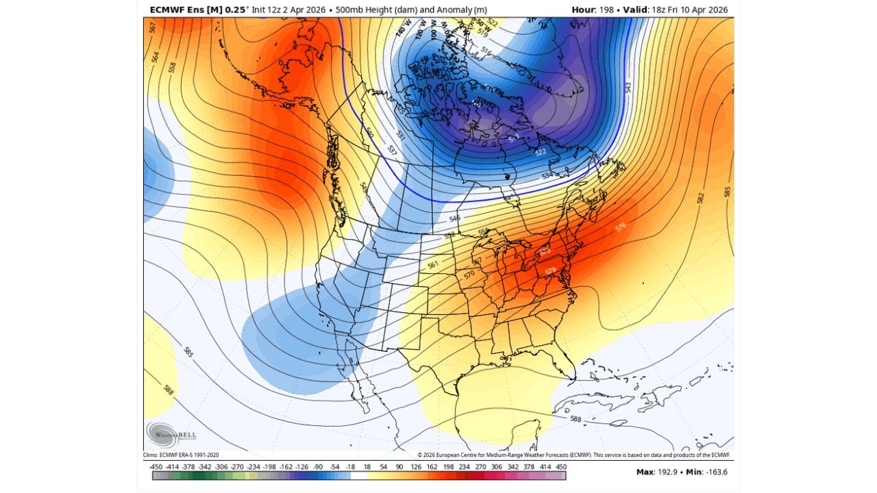
Latest ensemble guidance, including ECMWF model projections, shows a notable shift in the upper-level pattern across North America. A deep trough over central and northern regions is paired with warmer air building across the eastern United States, creating a contrast that often supports storm development.
This pattern alignment is particularly important for areas including Illinois, Indiana, Wisconsin, Michigan, and surrounding Midwest states, where temperature contrasts and atmospheric energy can fuel organized systems.
Although this is still a long-range signal, consistency across multiple model runs is beginning to increase confidence that something more active may take shape as the second week of April begins.
Ensemble Data Suggest Increasing Rainfall Chances Around April 10
Precipitation ensemble data shows a gradual uptick in rainfall probabilities beginning around April 9 through April 12, especially across parts of the Midwest and Great Lakes corridor.
While earlier days show relatively low precipitation signals, the data becomes more active approaching April 10, with multiple ensemble members indicating increasing coverage of measurable rainfall.
This type of trend typically suggests a transition from a quieter pattern to a more unsettled one, where storm systems begin to track more frequently across the region.
Midwest and Great Lakes Could See Renewed Storm Activity
If the current model trends hold, areas such as Chicago, Milwaukee, Detroit, Indianapolis, and surrounding regions could experience renewed storm chances, including periods of rain and possibly stronger thunderstorms depending on how instability develops.
The combination of upper-level support, moisture return, and temperature contrasts will determine how intense these storms become. At this stage, the primary takeaway is that conditions may become more favorable for organized weather systems compared to earlier in the week.
Forecast Still Uncertain but Trends Worth Monitoring
Despite increasing signals, forecasters emphasize that this setup is not yet finalized. Long-range forecasts can shift, especially several days out, meaning the exact timing, intensity, and location of storms may change.
However, the fact that models are consistently pointing toward a more active window around April 10 is a key signal that cannot be ignored.
Residents across the Midwest and Great Lakes should begin to monitor updates closely as newer data refines the forecast in the coming days.
As weather patterns begin to shift toward a more active setup, staying informed is essential. For continued updates on Midwest storm potential, forecasts, and regional weather coverage, visit ChicagoMusicGuide.com.