
United States Winter Pattern Signals Possible Storm Risk Across Illinois, Georgia, Carolinas, Virginia, and Mid-Atlantic Late Next Week
UNITED STATES — Long-range weather guidance is increasingly showing a return to an active and colder winter pattern across much of the central and eastern United States late next week, with portions of the Midwest, Southeast, and Mid-Atlantic potentially facing another round of winter weather impacts. While it is still too early to determine specific snowfall totals or exact impact zones, multiple signals suggest conditions may become favorable for wintry precipitation as colder air pushes south and interacts with an active storm track.
Colder-Than-Normal Temperatures Expanding East and South
Forecast temperature probability maps for the 6–10 day period show a strong signal for below-average temperatures stretching from the northern Plains through the Midwest and into the Ohio Valley, Southeast, and Mid-Atlantic. States including Illinois, Indiana, Missouri, Kentucky, Tennessee, Georgia, the Carolinas, Virginia, and Pennsylvania are increasingly likely to experience colder air by late next week.
In the Midwest, this cold air could be severe, with dangerously low wind chills possible, especially in open and rural areas. Farther south, temperatures may hover close enough to freezing to support snow, sleet, or freezing rain if moisture becomes involved.
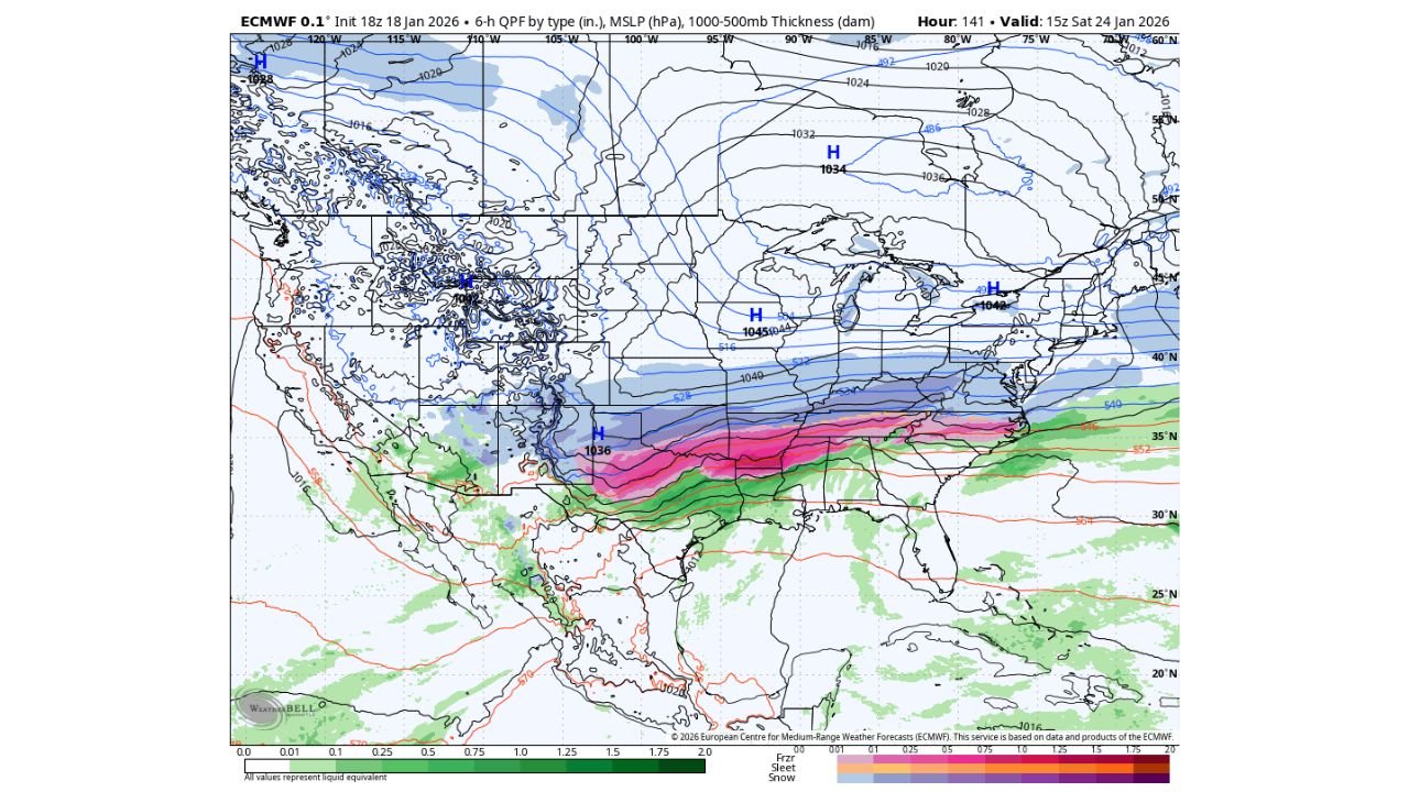
Storm Track Favors Southern Plains to East Coast Setup
Medium-range model guidance shows an active storm corridor developing from the Southern Plains eastward toward the Southeast and Mid-Atlantic. This pattern raises concern because it places several regions near the boundary between cold air to the north and warmer air to the south — a classic setup for mixed winter precipitation.
If this configuration holds, snow would be favored north of the storm track, while ice or sleet could become an issue farther south, particularly across parts of Georgia, South Carolina, North Carolina, and Virginia. Ice accumulation remains a key concern in these setups, even when snowfall totals are uncertain.
Why Specific Impacts Cannot Yet Be Defined
At this range — roughly 7 to 10 days out — forecasters are not attempting to predict snowfall amounts, exact locations, or travel impacts. Instead, the focus is on pattern recognition:
- The large-scale setup supports winter weather potential
- Cold air appears strong and persistent
- Storm energy is present and active
What remains unclear is timing, storm strength, and exact placement. Small shifts in temperature of just a degree or two can significantly change outcomes, especially in the Southeast and Mid-Atlantic where rain, snow, or ice lines are often very tight.
What Forecasters Will Watch in the Coming Days
As the system moves closer into the 5–7 day window, meteorologists will begin evaluating whether models agree on:
- Storm timing and track consistency
- Depth and persistence of cold air
- Whether precipitation overlaps with the coldest air
Inside 3–5 days, clearer answers typically emerge regarding precipitation type. Only within 1–3 days can snowfall or ice amounts be discussed with confidence.
Bottom Line for Now
This setup currently falls into the “possible winter storm” category — not a guaranteed event, but not something to ignore either. The pattern supports cold and active weather, meaning multiple opportunities for winter systems may develop over the next couple of weeks.
Residents across Illinois, Georgia, the Carolinas, Virginia, and surrounding states should stay informed, remain flexible with plans, and understand that long-range forecasts are about awareness, not alarms.
Updates will become clearer as confidence increases and model agreement improves later this week.