
Unusual Christmas Warmup Expected Across Illinois, Indiana, Ohio, and the East Coast as Long-Range Weather Data Shows a Powerful Ridge Pattern Building
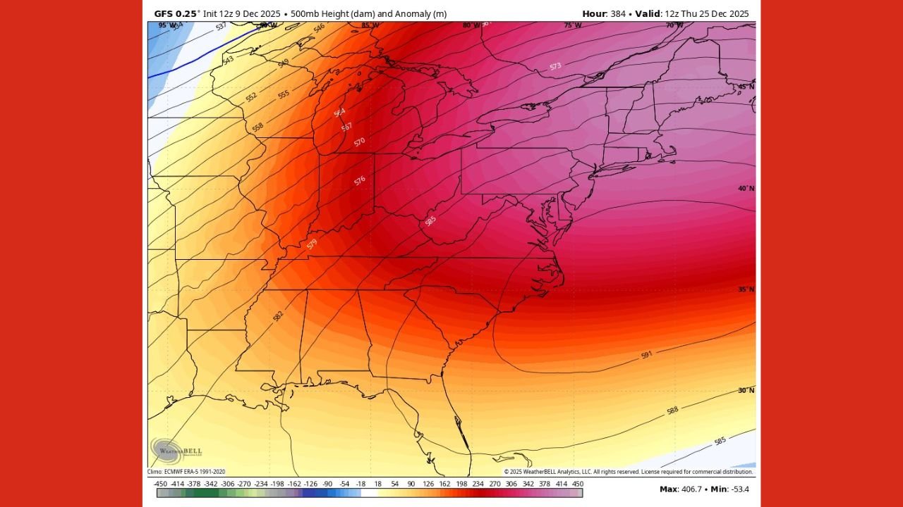
ILLINOIS — New long-range weather projections are pointing toward a surprisingly warm setup for Christmas this year, with a broad dome of high pressure expected to extend across Illinois, Indiana, Ohio, the Mid-Atlantic, and parts of the Southeast. Atmospheric analysis shows a strong upper-level ridge building over much of the eastern United States, signaling temperatures far above what is normally expected on December 25.
This developing pattern suggests that the traditional holiday chill may be replaced by a milder, almost spring-like feel for millions of people across the region.
A Strong Ridge Pattern Could Dominate Christmas Week
Weather data shows a large, persistent ridge of warm upper-level air stretching from the Gulf states up through the Great Lakes and into the Northeast. While exact temperatures will vary from state to state, the overall setup strongly favors a warm Christmas across:
- Illinois
- Indiana
- Ohio
- Kentucky
- Tennessee
- Virginia
- Maryland
- Pennsylvania
- New Jersey
- New York
- The Carolinas
Maps from the latest atmospheric analysis indicate unusually high height values in the central and eastern U.S., which typically correspond with warmer surface temperatures.
This suggests residents from Chicago to Cincinnati, Nashville to Washington, D.C., and up through Philadelphia and New York City could all experience milder-than-normal holiday weather.
What Christmas Temperatures Could Look Like
Although exact numbers are still developing, the overall pattern points toward:
- Above-normal temperatures across the Midwest and Great Lakes
- Warm conditions spreading into the Ohio Valley and Mid-Atlantic
- Potentially record-challenging warmth in parts of the Southeast
This type of ridge pattern often means:
- Clearer skies
- Reduced snow chances
- A higher likelihood of rain rather than wintry weather
Chicago, Indianapolis, and Cleveland may see conditions far from the classic white Christmas scene, and Eastern cities could experience temperatures more typical of early November than late December.
Why This Ridge Pattern Matters
A ridge of this size and strength influences the entire holiday week, not just Christmas Day. Its effects include:
- A widespread warm spell across multiple states
- Suppressed Arctic cold from moving south
- More stable weather with fewer storm systems developing
For holiday travelers, this could bring smoother road conditions and fewer weather-related delays — though areas north of the ridge, including northern Michigan or parts of New England, may still see colder air nearby.
The Bottom Line for Holiday Plans
If the current pattern holds, millions across the eastern half of the country may experience an unusually warm Christmas. For Illinois, Indiana, Ohio, and surrounding states, this could mean:
- A more comfortable holiday for outdoor gatherings
- Reduced heating needs
- Lower chances of snow or icy conditions
Still, weather patterns can shift, and updates will refine the temperature outlook as the holiday approaches.
Are you hoping for a warm Christmas this year, or were you counting on holiday snow? Share your thoughts with us — and keep checking ChicagoMusicGuide.com for more weather updates and stories impacting your community.