
Utah and Southwest Wyoming Braced for 8–20 Inches of Mountain Snow as Winter Storm Watch Covers Wasatch and Uinta Ranges Through Friday
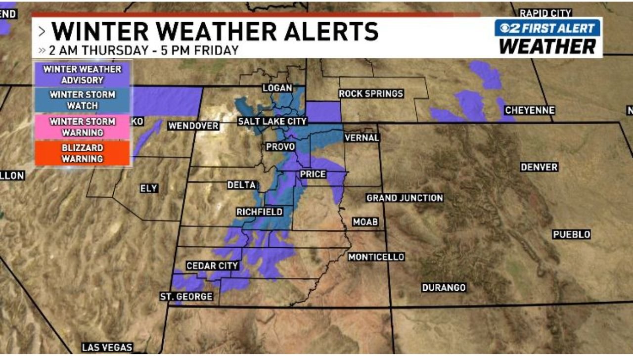
UTAH — A powerful late-week winter system is set to sweep across the state, placing the Wasatch Mountains, Western Uinta Mountains, and parts of southwest Wyoming under a Winter Storm Watch from Thursday morning through Friday afternoon, with significant mountain snowfall expected.
Forecasters are warning of 8 to 14 inches of snow across the Wasatch and Western Uinta ranges, with localized totals approaching 20 inches in the Upper Cottonwoods. Travel through higher elevations could become hazardous, particularly during heavier bursts of snow.
Where the Heaviest Snow Is Expected
The most substantial accumulations are forecast in:
- Wasatch Mountains, including areas near Salt Lake City’s surrounding peaks
- Upper Cottonwoods, where totals could reach 20 inches
- Western Uinta Mountains
- Central Mountains, including Fish Lake, Cove Fort, and Joes Valley (6–14 inches)
These totals fall under the Winter Storm Watch, indicating the potential for significant impacts.
Winter Weather Advisories in Place
In addition to the watch areas, a Winter Weather Advisory covers:
- Wasatch Back and southwest Wyoming (3–8 inches)
- Sanpete and Sevier Valleys (2–4 inches)
- Southern Mountains of Utah (4–9 inches)
Communities near Logan, Provo, Richfield, Cedar City, Price, and Vernal may see periods of accumulating snow, especially at higher elevations.
Storm Timeline: Two Rounds of Snow
Snow is expected to move in with a cold front early Thursday morning, bringing heavy bursts at times.
Forecasters anticipate:
- Initial surge Thursday morning
- A relative break Thursday afternoon
- Renewed snowfall late Thursday into Friday
This staggered pattern means mountain roads could see deteriorating conditions multiple times through the event window.
Mountain Travel Could Become Dangerous
Travel through high-elevation passes — including routes near Salt Lake City’s mountain corridors, Logan Canyon, and central Utah mountain highways — may become slick and snow-covered.
Rapid accumulation during heavier bands could reduce visibility and create chain or traction law conditions.
Regional Context: Why This Storm Matters
Late-season snow events like this can significantly impact:
- Ski resort operations in the Wasatch
- Interstate and mountain pass travel
- Avalanche conditions in higher terrain
With up to 20 inches possible in favored zones, this system could deliver one of the more notable mountain snowfalls of the week across Utah.
Bottom Line
A Winter Storm Watch remains in effect for the Wasatch and Western Uinta Mountains, with heavy snow expected Thursday through Friday. Advisories extend into southwest Wyoming and central Utah valleys, where lighter but still impactful accumulations are possible.
Anyone planning mountain travel across Utah should prepare for rapidly changing conditions and allow extra time.
ChicagoMusicGuide.com will continue tracking major national weather systems impacting travel and communities across the country.