
Utah, Arizona, Nevada, and New Mexico Brace for Potentially Historic March Heat Wave as Temperatures Soar 25–30 Degrees Above Normal Across the Southwest
SALT LAKE CITY, UTAH — A powerful and potentially historic March heat wave is setting up across Utah and the broader Southwest United States, with forecast models signaling temperatures running 25 to 30 degrees above normal between March 17 and March 21. The developing ridge of high pressure could push widespread 80s and even 90s into parts of Utah, placing multiple daily and possibly all-time March records in jeopardy.
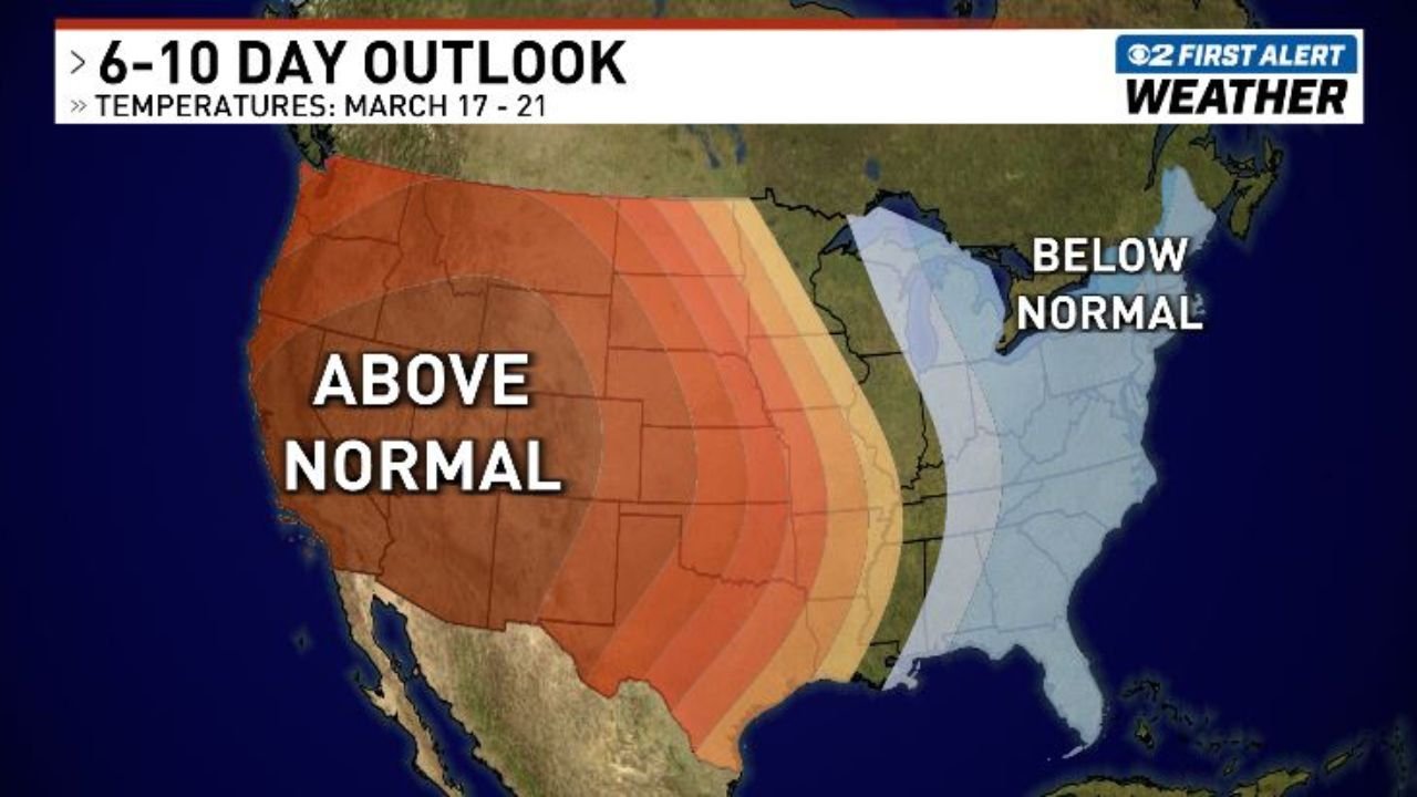
The latest 6–10 day outlook highlights a large swath of above-normal temperatures covering Utah, Arizona, Nevada, New Mexico, and much of the Southwest, while the eastern United States trends below normal during the same period.
Strong Ridge of High Pressure Expands Over the Southwest
Forecast guidance shows a very strong ridge of high pressure building across the western United States. This upper-level ridge acts like a lid on the atmosphere, suppressing storm systems and allowing sinking air to compress and warm at the surface.
Under this pattern, cities across Utah, including Salt Lake City, could experience temperatures far above seasonal averages. Mid-March normals typically support highs in the 50s or lower 60s in northern Utah, making projected highs in the 80s particularly significant.
The ridge’s footprint extends across:
- Arizona
- Nevada
- New Mexico
- Portions of Colorado
- Parts of California
The widespread nature of the anomaly suggests this will not be an isolated warm day, but rather a multi-day stretch of unseasonably intense heat.
25–30 Degrees Above Normal Could Shatter Records
Forecasters indicate that temperatures could run 25 to 30 degrees above climatological averages across the Southwest. In Utah, that could translate to highs reaching well into the 80s and possibly touching the 90-degree mark in lower elevation areas.
Such warmth this early in the season would not qualify as a typical early-spring warm spell. Instead, it raises the possibility of record-breaking values, particularly if overnight lows also remain elevated.
When anomalies reach this magnitude in mid-March, daily records often fall. If the ridge strengthens further, some locations could approach or surpass all-time March records, especially across southern and central Utah.
A Prolonged Event From March 17 to 21
Unlike short-lived temperature spikes, this heat event appears poised to persist for several consecutive days from Wednesday through Saturday (March 18–21).
Extended warmth compounds impacts, including:
- Accelerated snowmelt in mountain regions
- Early-season fire weather concerns
- Increased water demand
- Stress on vulnerable populations sensitive to heat
The Southwest’s arid climate amplifies daytime heating under strong ridging patterns, allowing temperatures to climb quickly when skies remain clear.
Contrasting Pattern Across the United States
While the Southwest and Utah bake under above-normal conditions, the Great Lakes, Midwest, and parts of the Eastern United States are forecast to experience below-normal temperatures during the same period.
This sharp east-west contrast reflects a highly amplified jet stream pattern. Warm air surges northward across the western half of the country, while cooler air settles into the eastern states.
Such amplified patterns are often responsible for extreme temperature swings and record-setting events.
As mid-March approaches, residents across Utah, Arizona, Nevada, and New Mexico should monitor local forecasts for potential record highs and related advisories.
For continued updates on major weather shifts and record-setting climate events across the United States, visit ChicagoMusicGuide.com.