
Utah’s Cottonwoods Lose Nearly 100 Inches of Snow in Days as Record June-Like Heat Rapidly Erases State Snowpack
SALT LAKE CITY, UTAH — Nearly all of the snow that piled up across Utah’s mountains in February and March — including close to 100 inches in the Cottonwoods — is vanishing under a surge of record, June-like heat that has rapidly erased much of the state’s snowpack.
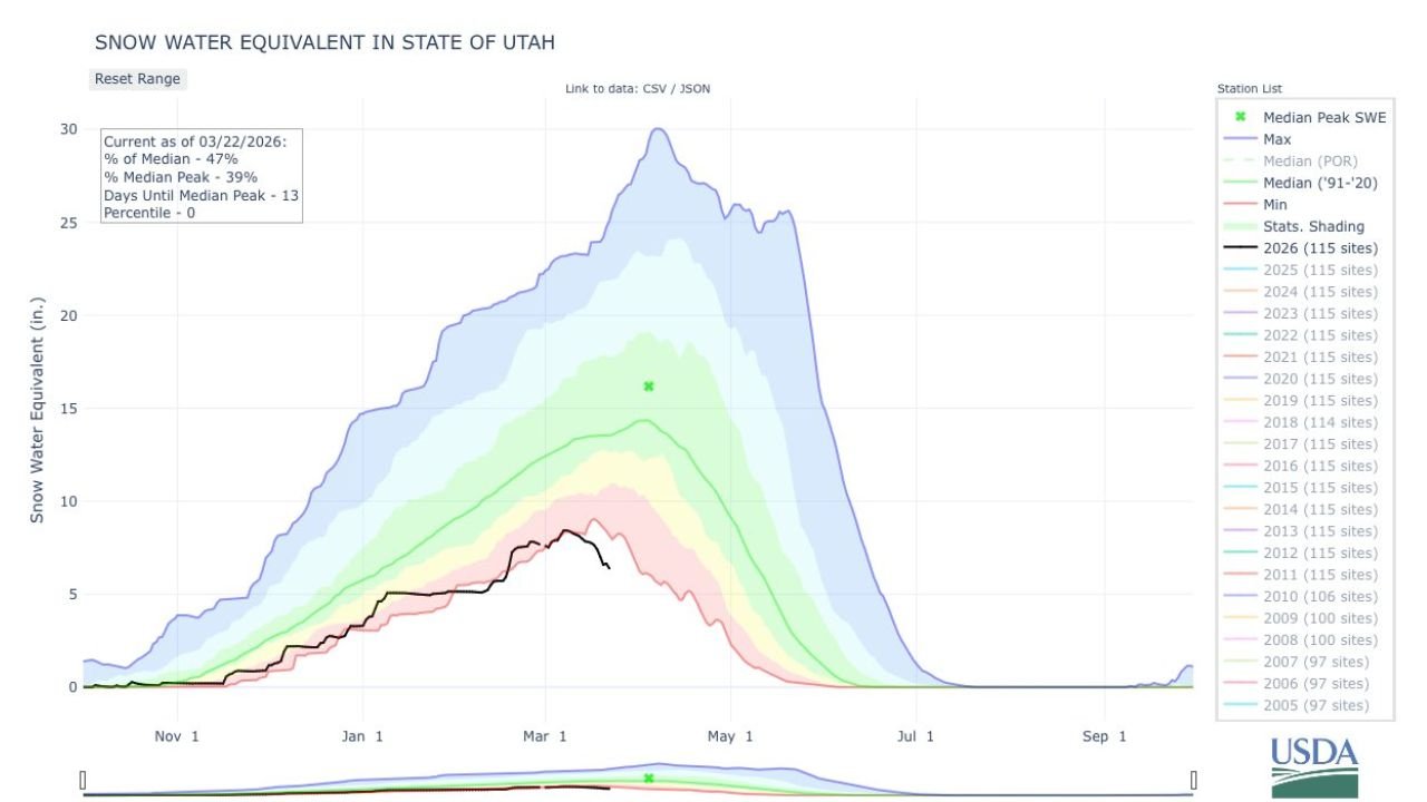
New statewide snow water equivalent data shows a dramatic drop in snowpack levels as of March 22, 2026, highlighting just how quickly conditions have changed.
Snowpack Plunges Well Below Normal
According to the latest statewide measurements:
- Current Snow Water Equivalent: 47% of median
- Percent of Median Peak: 39%
- Days Until Median Peak: 13
- Percentile Ranking: 0
With nearly two weeks remaining before the typical seasonal peak, Utah’s snowpack is already sitting at just 39% of where it would normally peak — an alarming signal this early in the spring runoff season.
The percentile ranking of zero indicates the current snowpack level is at the very bottom of the historical distribution for this date.
Cottonwoods See Rapid Loss
The Cottonwood Canyons, which picked up roughly 100 inches of snow during late winter storms, are now seeing that accumulation disappear quickly under intense warmth.
Temperatures more typical of early June than late March have accelerated melting across mid- and upper-elevation terrain. The snowpack curve for 2026 shows a sharp downturn compared to the historical median and even recent lower-snow years.
The current trajectory places 2026 significantly below the long-term median line and well under the more robust snow seasons of recent years.
Heat Driving the Collapse
The rapid melt coincides with a widespread heat event that pushed temperatures far above seasonal norms across Utah and the broader West.
When snowmelt accelerates this quickly:
- Streamflows can spike earlier than normal
- Reservoir recharge timing shifts
- Water supply outlooks become more uncertain
The concern is not just how much snow fell, but how long it remains stored in the mountains. Fast melt events reduce the gradual release that water managers rely on through spring and early summer.
A Critical Stretch Ahead
With the median snowpack peak still about two weeks away climatologically, Utah would typically expect additional accumulation or at least maintenance of existing snow levels.
Instead, snow water equivalent values are already collapsing.
If above-normal warmth continues, the state could enter April with a snowpack profile more typical of late spring.
What It Means for Water and Fire Season
Rapid early-season melt can:
- Shorten the duration of spring runoff
- Increase early wildfire risk if drying follows
- Reduce sustained summer water supply stability
Utah’s mountain snowpack acts as the state’s largest natural reservoir. Losing a large share of it before April raises long-term seasonal concerns.
The situation remains fluid, but the message is clear: record warmth has dramatically reshaped Utah’s snow outlook in just days.
For continued coverage of major climate and weather shifts across the United States, stay with ChicagoMusicGuide.com.