
Valentine’s Day Weekend Storm May Threaten Mississippi Valley, Southern States, Carolinas, and Mid-Atlantic With Severe Weather and Possible Winter Impacts
UNITED STATES — A potentially impactful storm system is expected to develop around Valentine’s Day weekend, with early indications pointing to initial formation near the Mississippi Valley before tracking eastward through parts of the Southern United States and possibly into the Southeast and Mid-Atlantic regions. While the system remains several days away and details are highly uncertain, current signals suggest a storm capable of producing severe weather, heavy rain, and possibly wintry precipitation on its colder side, depending on how it ultimately evolves.
Meteorologists stress that this is an early outlook, but enough ingredients are present to warrant close monitoring as mid-February approaches.
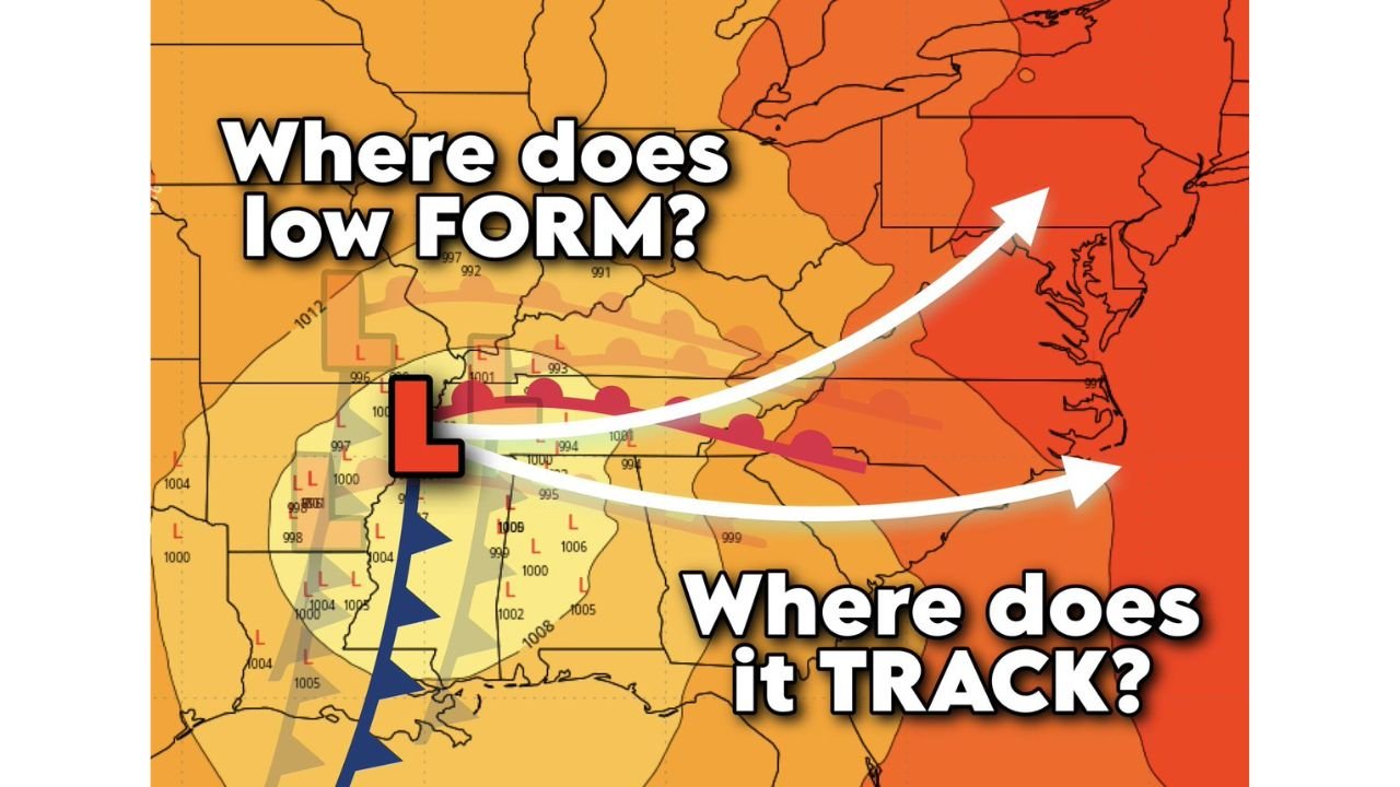
Storm May Form Over the Mississippi Valley Before Moving East
Long-range guidance suggests the storm could take shape somewhere over the Mississippi Valley, a common breeding ground for large, dynamic systems during the winter transition season. From there, the developing low-pressure system would likely track eastward, potentially affecting states across the Lower Mississippi Valley, Deep South, and eventually the Southeast or Mid-Atlantic.
At this stage, forecast models differ on the exact placement and strength of the surface low, which remains one of the most important factors in determining who sees severe weather versus colder, wintry conditions.
Severe Weather Possible Across the Southern States
On the warm side of the storm, conditions may become favorable for severe weather, particularly across portions of the South. Forecast signals indicate the potential for damaging wind gusts, and in a worst-case scenario, isolated tornadoes cannot be ruled out if instability and wind shear align.
In addition to wind-related threats, heavy rainfall is also possible across the warm sector of the storm. Areas that experience repeated downpours could face localized flooding concerns, especially if soils are already saturated heading into the weekend.
Cold Side of the Storm Remains Highly Uncertain
While the warm side threats are becoming more evident, the cold side of the system is far more uncertain. A key question centers on whether cold air will become entrenched in the Appalachian region. If cold air can hold its ground, wintry precipitation could develop across parts of the higher terrain.
This uncertainty is typical for systems that form days in advance, especially when the source disturbance driving the storm is still far from North America.
Snow or Ice Hinges on the Storm’s Exact Track
The eventual path of the storm will be critical. A more southerly track would place parts of the Mid-Atlantic states and the Carolinas on the colder side of the system, opening the door for snow or ice accumulations, particularly in elevated areas and along the eastern slopes of the Appalachians.
Conversely, a more westerly track up the Appalachian spine would keep much of the Carolinas and Mid-Atlantic firmly in the warm sector, resulting in mostly rain and gusty winds rather than winter weather. Small shifts in the storm’s path could make a significant difference in impacts.
Why Confidence Is Still Low at This Stage
Forecasters emphasize that it is far too early to provide specific snowfall totals, ice amounts, or severe weather probabilities. The upper-level disturbance responsible for this system is currently located well south of Alaska over the Pacific Ocean, meaning it has not yet been fully sampled by observational networks.
Until that energy moves closer and enters more reliable forecast ranges, uncertainty will remain high. What is clear, however, is that Valentine’s Day weekend has the potential to be stormy across a large portion of the eastern half of the country.
What to Watch in the Coming Days
As the week progresses, forecasters will be watching:
- Where the surface low ultimately forms
- How far south cold air can push into the Appalachians
- Whether severe weather ingredients align across the South
- If winter weather becomes a realistic concern for the Carolinas or Mid-Atlantic
Refinement in these details is expected as the system moves closer to North America and confidence increases.
With a potentially active Valentine’s Day weekend shaping up across the Mississippi Valley, Southern states, Carolinas, and Mid-Atlantic, ChicagoMusicGuide.com will continue monitoring forecast trends and breaking down what they could mean for travel, events, and regional impacts. For ongoing weather updates and clear explanations of developing storm systems, visit ChicagoMusicGuide.com.