
Washington and Oregon Brace for Major Flooding Threat as New Atmospheric River Targets the Pacific Northwest
PACIFIC NORTHWEST — Another powerful atmospheric river is preparing to slam into western Washington and Oregon, bringing a dangerous stretch of heavy rainfall, rising rivers, landslides, and the potential for significant flooding beginning Tuesday and continuing through Wednesday night.
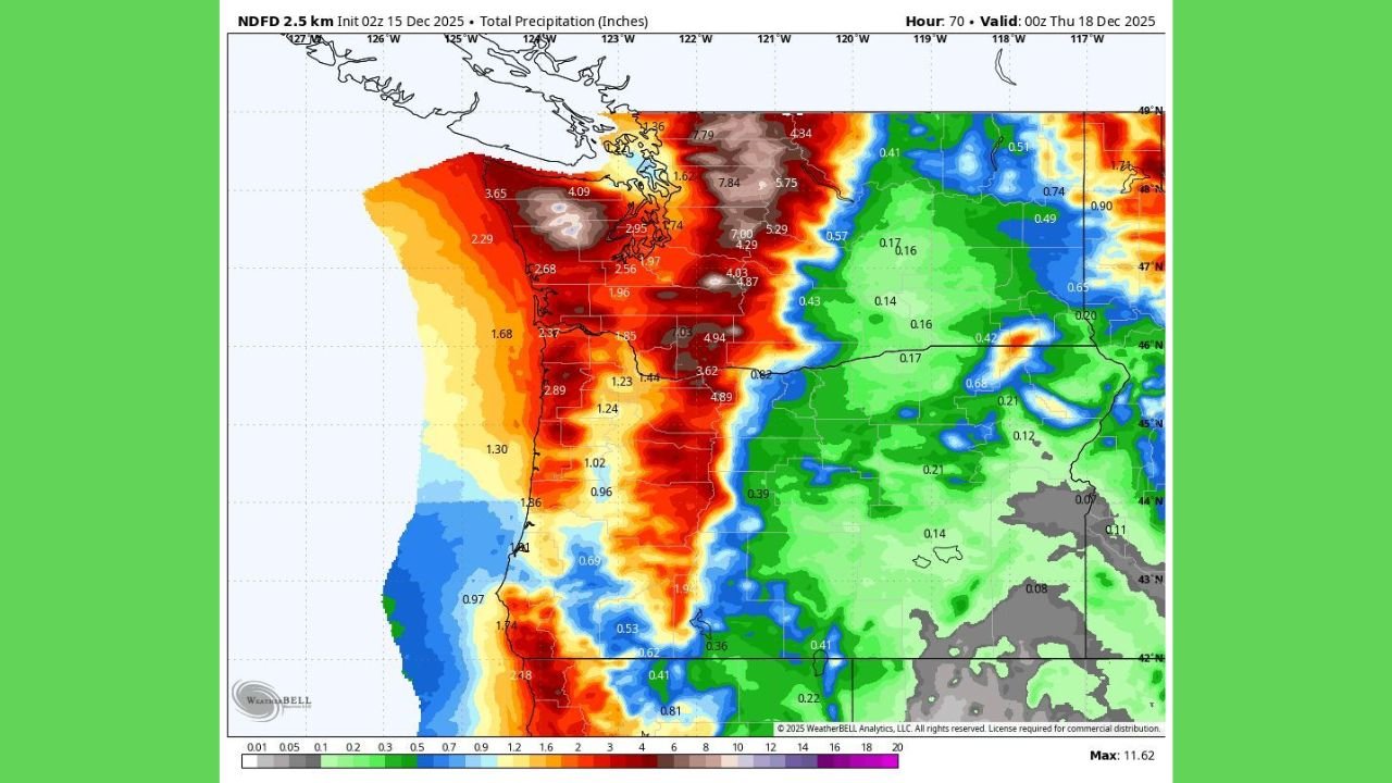
Meteorologists warn that this incoming system may become one of the most impactful rainfall events of December, especially with soils already saturated from last week’s storm. Forecast models indicate 3 to 7 inches of rain for many low-elevation communities, while the Cascades and Olympic Mountains could see 8 to 11 inches of precipitation — enough to rapidly overwhelm drainage systems and trigger flash-flood conditions.
Heavy Rainfall Expected Across Washington and Oregon
The newest forecast data highlights a direct hit along the western slopes of the Cascades and coastal mountain ranges. Key projections include:
- 4 to 7 inches across the I-5 corridor from Portland to Seattle
- Locally 8 to 11 inches in the Cascades and Olympics
- 3 to 5 inches in southwest Washington and northwest Oregon
- Coastal zones expected to see widespread flooding potential
The rainfall map included in today’s model run shows an intense, persistent plume of moisture funneling directly into the Pacific Northwest, maintaining high precipitation rates for nearly 36 consecutive hours.
High Risk of Flooding, Landslides, and River Rises
With the ground already saturated, the region faces heightened hazards:
- Flash flooding in urban and low-lying areas
- Rapid river rises, especially in western Washington
- Mudslides and landslides along steep terrain and road embankments
- Road washouts and travel disruptions
- Strong runoff flowing from higher elevations into populated valleys
Emergency managers advise residents in flood-prone regions to prepare now, monitor alerts closely, and avoid driving through areas where water is covering the roadway.
Timing of the Event
- Rain begins intensifying late Tuesday morning
- Peak flooding risk: Tuesday night through Wednesday evening
- Moisture plume weakens late Wednesday night, but rivers may continue to rise into Thursday
The National Weather Service is expected to issue flood watches and warnings as conditions develop.
Why This System Is So Dangerous
Atmospheric rivers act like conveyor belts of warm, moisture-rich air streaming from the Pacific. When these rivers repeatedly target the same region — as is happening this month — the cumulative rainfall dramatically increases the threat of flooding.
With no drying time between events, the soil cannot absorb additional water, forcing excess runoff into rivers, streams, and drainage systems.
What Residents Should Do
Authorities recommend:
- Checking that storm drains near homes are clear
- Preparing sandbags in historically flood-prone areas
- Monitoring real-time radar and river gauges
- Avoiding travel during peak rainfall
- Staying away from rapidly flowing water or unstable slopes
Officials stress that this will be a high-impact weather event, and the public should stay vigilant.
For continuing weather updates, safety information, and regional forecasts, keep visiting ChicagoMusicGuide.com.