
Washington and Oregon Face Another Dangerous Atmospheric River as Third Storm Brings Flooding Rain and Mountain Snow
PACIFIC NORTHWEST — A new and potentially more destructive round of atmospheric river rainfall is set to begin Monday, threatening communities across Washington and Oregon with flooding, landslides, road washouts, and dangerous travel conditions. Forecast models show this incoming plume of moisture as the third major atmospheric river event in just over a week, hitting an already saturated region that has struggled to recover between storms.
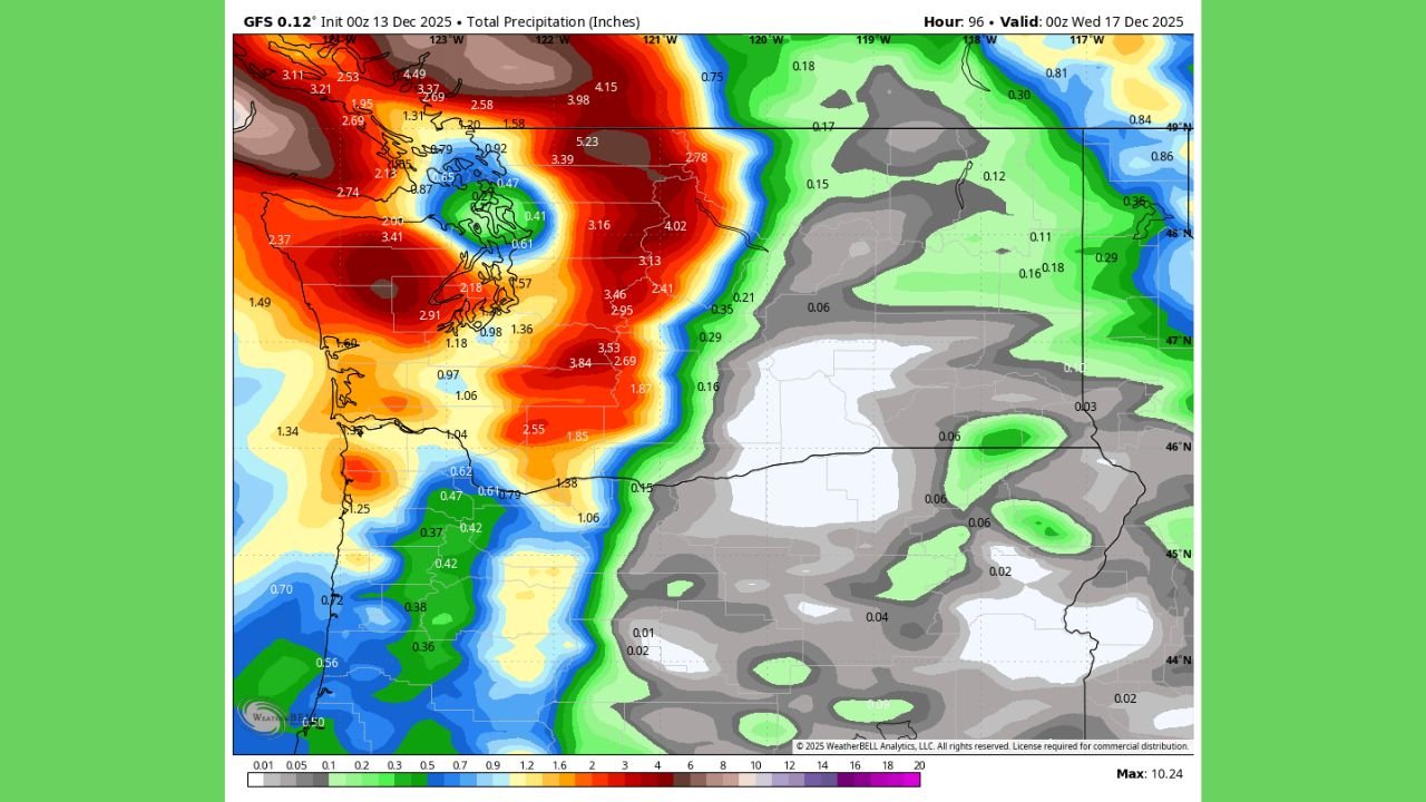
Heavy Rainfall and Flooding Threat Through Wednesday
The latest guidance shows widespread rainfall totals of 3 to 7 inches across western Washington and Oregon, with localized amounts up to 11 inches in the higher terrain of the Cascades and Olympic Mountains.
Maps indicate the heaviest precipitation concentrated along the coast, the foothills, and major river basins still swollen from prior storms.
With soils unable to absorb additional moisture, forecasters warn that even moderate rainfall could trigger:
- Rapid river rises
- Flash flooding
- Road closures and washouts
- Mudslides and landslides, especially near burn scars
- Disruptions to mountain passes already struggling with debris and snow buildup
Officials note that the situation is worsened by the short recovery window between atmospheric river events, leaving infrastructure vulnerable.
Snow in the Cascades Will Complicate Emergency Response
While the lowlands will see heavy rain, colder air at elevation will convert moisture to significant mountain snow, likely impacting:
- Snoqualmie Pass
- Stevens Pass
- White Pass
- Santiam Pass
Deep snowfall will slow or block repair work, further complicating efforts to stabilize damaged roadways and restore community access.
Emergency managers warn that travel through these areas may become extremely dangerous or impossible at times.
Communities Already Hit Hard Could Face Worse Conditions
Many parts of Washington and Oregon are still recovering from:
- Downed trees
- Flooded neighborhoods
- Landslide damage
- Washed-out rural roads
- Widespread power outages
This third round threatens to intensify damage and push some communities into what meteorologists call a near worst-case scenario.
Residents in flood-prone or landslide-prone zones are urged to stay alert, monitor local alerts, and prepare for possible evacuation orders.
Outlook and What Comes Next
Forecasters say the atmospheric river will remain in place through Wednesday night, with rain gradually decreasing late in the week. However, soil saturation and river levels may continue rising even after rainfall diminishes.
Additional systems may approach the region later in December, depending on evolving Pacific patterns.
Stay Prepared and Informed
With another high-impact storm underway, residents across Washington and Oregon should continue tracking updates from the National Weather Service and local emergency agencies.
For more weather alerts, analysis, and community updates, stay connected with ChicagoMusicGuide.com.