
Washington and Oregon Face Potentially Historic Christmas Wind Storm as Forecast Models Signal Widespread Power Outage Risk
UNITED STATES — A powerful Pacific storm system is raising serious concern across Washington and Oregon, as multiple high-resolution forecast models indicate the potential for a rare, high-impact wind event coinciding with the Christmas holiday, a scenario that could leave millions without power if worst-case projections materialize.
Recent forecast data shows strengthening confidence in a major windstorm developing as a deep low-pressure system moves up the California coast before rapidly intensifying near the Pacific Northwest. Meteorologists caution that while uncertainty remains, some model guidance now depicts damaging wind gusts rivaling historically disruptive windstorms in the region.
Forecast Models Show Increasing Risk of a High-Impact Wind Event
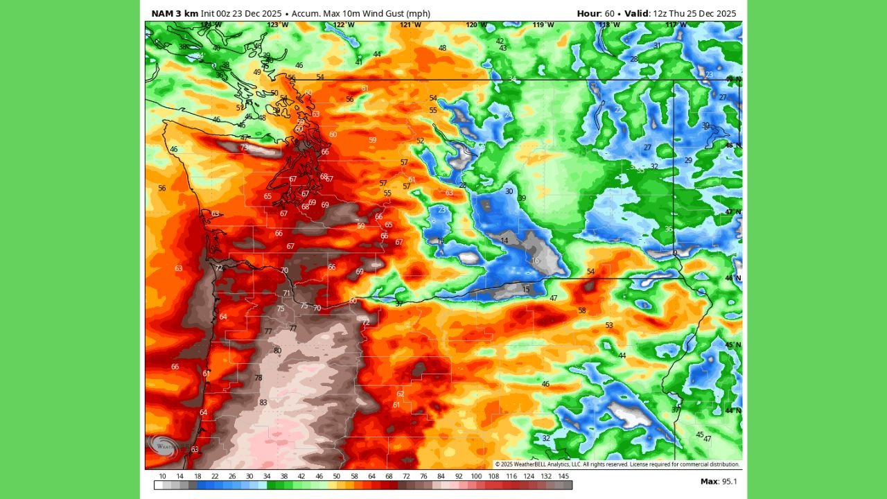
Several major weather models are currently offering conflicting but concerning signals. The NAM (North American Mesoscale) model, often considered reliable at shorter lead times, has repeatedly shown a Columbus Day–style windstorm scenario, characterized by widespread damaging gusts across western Washington and Oregon.
Meanwhile, the GFS model has significantly upgraded wind intensity projections in its latest overnight runs, increasing confidence that this system cannot be dismissed as routine. Although the EURO model briefly backed off earlier solutions, forecasters note that its earlier detection of the storm suggests model volatility rather than storm disappearance.
At this stage, the NAM depiction represents a worst-case scenario, but meteorologists stress that verification will depend on how quickly the surface low intensifies once it moves north along the coast.
Wind Gusts Could Exceed 70 MPH in Vulnerable Areas
Model-generated wind maps show widespread gusts of 60–70 mph across coastal and lowland areas, with higher gusts possible in exposed terrain, coastal headlands, and mountain gaps. Urban corridors including Seattle, Tacoma, Portland, and surrounding metro regions could experience damaging winds strong enough to down trees, power lines, and infrastructure.
Of particular concern is the timing. With the storm projected to peak on Christmas Day, emergency response capabilities and utility repair crews could face logistical challenges during an already resource-strained holiday period.
Millions Could Lose Power If Worst-Case Scenario Verifies
Forecasters warn that if the NAM solution verifies, the Pacific Northwest could see one of its most disruptive wind events in years, especially given saturated soils from a historically wet month of rainfall. Wet ground dramatically increases the risk of tree fall, compounding outage potential.
Utility experts caution that extended power outages lasting multiple days are possible if transmission corridors sustain widespread damage. In such a scenario, heating, travel, and emergency services could all be affected during critical winter conditions.
Confidence Will Increase as Storm Moves Up the Coast
Meteorologists emphasize that greater forecast confidence will arrive once the storm system becomes better observed over the eastern Pacific and California coastline. Until then, residents across Washington and Oregon are urged to closely monitor forecasts, prepare for potential outages, and ensure emergency plans are in place.
While it remains possible the system weakens, the growing signal across multiple models means this storm warrants serious attention, especially given its timing and potential impacts.
As Christmas approaches, residents in the Pacific Northwest should stay weather-aware and prepared. What do you think — will this storm live up to its early hype, or fade as it approaches? Share your thoughts and stay updated with the latest weather coverage at ChicagoMusicGuide.com.