
Washington, D.C. and Baltimore Metro Brace for Chilly Rain-to-Snow Transition Sunday Night as I-95 Corridor Splits Between Slush and Soaking Rain
WASHINGTON, D.C. — A weekend system is poised to bring a messy mix of rain and snow to the Baltimore–Washington corridor Sunday afternoon into early Monday, with colder air wrapping in late enough to flip parts of the region to snow—especially north and west of Interstate 95.
According to the latest update (as of Saturday 4 PM), precipitation is expected to begin as a chilly rain across the entire Baltimore Metro by mid-afternoon Sunday. Temperatures will hover in the mid-30s for much of the urban corridor, keeping most early precipitation liquid.
But the setup becomes more complicated Sunday night.
Rain Arrives First Across the Baltimore–D.C. Corridor
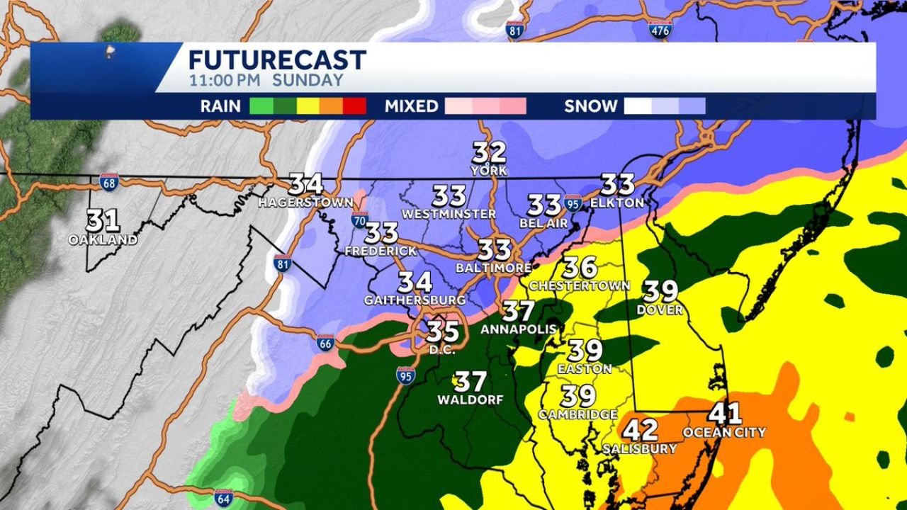
Futurecast guidance for 11:00 PM Sunday shows rain dominating much of central and southern Maryland, including:
- Washington, D.C. – 35°F
- Waldorf – 37°F
- Annapolis – 37°F
- Chestertown – 36°F
- Easton – 39°F
- Cambridge – 39°F
- Salisbury – 42°F
- Ocean City – 41°F
- Dover – 39°F
These readings strongly favor rain across southern Maryland and the Eastern Shore Sunday evening, with no significant accumulation expected in those areas.
Snow Develops North and West of I-95 Late Sunday Night
Colder air begins to filter in from the northwest late Sunday night—between 10 PM and Midnight—allowing rain to transition to snow in higher elevations and inland communities.
By 11 PM, the following areas are shown at or near freezing with snow falling:
- Westminster – 33°F
- Frederick – 33°F
- Baltimore – 33°F
- Bel Air – 33°F
- Elkton – 33°F
- York – 32°F
- Hagerstown – 34°F
- Oakland – 31°F
The heaviest snow potential appears north and west of I-95, where colder air arrives earlier and sticks longer.
Forecasters suggest around 1 inch of snow is possible in these northern and western zones before precipitation tapers off between 3 AM and 5 AM Monday.
I-95 Becomes the Battle Line
The I-95 corridor—including Baltimore and D.C.—may sit right on the rain/snow line for several hours.
At 11 PM Sunday:
- Baltimore is projected at 33°F, meaning snow could mix in or briefly dominate.
- D.C. remains slightly warmer at 35°F, likely keeping precipitation mainly rain or a rain/snow mix with minimal accumulation.
Road impacts will depend heavily on surface temperatures. With ground warmth from recent mild days, accumulations may struggle on major highways—but grassy and elevated surfaces could pick up a slushy coating.
Eastern Shore Likely Stays Rain
Temperatures in the upper 30s to low 40s across:
- Salisbury
- Cambridge
- Easton
- Ocean City
…suggest mainly rain through the duration of the event.
Any wintry mix there would be brief and unlikely to accumulate.
Timing Breakdown
- Mid-Afternoon Sunday: Rain develops across the Baltimore Metro.
- 10 PM – Midnight: Transition to snow north and west of I-95.
- Overnight: Light accumulation possible (around 1″).
- 3 AM – 5 AM Monday: Precipitation ends.
Travel Impacts
Late Sunday night and early Monday morning commuters north and west of Baltimore should monitor conditions closely. Even a light accumulation can create slick secondary roads and untreated surfaces.
Major urban corridors along I-95 may see mostly wet roads, but brief slushy bursts are possible if snowfall rates intensify.
What This Means for the Region
This is not a major winter storm—but it is a classic Mid-Atlantic “thread-the-needle” setup, where a few degrees make all the difference between soaking rain and measurable snow.
If colder air pushes in faster than expected, snowfall totals could tick slightly higher in northern Maryland and southern Pennsylvania. If warm air holds longer, totals could shrink significantly.
That uncertainty is why forecasters are urging residents to stay tuned through Sunday.
For continued updates on shifting rain-snow lines and overnight travel impacts, keep checking back with ChicagoMusicGuide.com as we track this evolving late-winter system.