
Washington, D.C., Maryland & Northern Virginia Snowstorm Breakdown: How a 20–30 Mile Track Shift Turned a 3–6” Forecast Into Sharp Neighborhood Swings
WASHINGTON, D.C. — One of the most difficult winter storms to forecast in more than two decades delivered a sharp reminder of how small atmospheric shifts can produce major snowfall differences across the D.C. metro area.
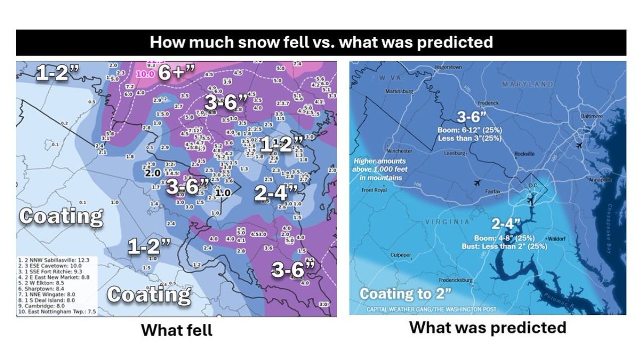
A detailed snowfall review comparing what was predicted vs. what actually fell shows that temperature margins of just 1–2 degrees, a subtle eastward storm track adjustment, and small-scale banding features dramatically altered totals across Washington, D.C., Northern Virginia, and Maryland.
What Was Forecast
The official forecast heading into the event projected:
- 3–6 inches across much of the metro region
- 2–4 inches in southern zones
- “Coating to 2 inches” in lighter areas
- Higher totals in elevated terrain west of the city
Forecasters clearly communicated uncertainty, even outlining boom and bust scenarios:
- 25% chance of 6–12 inches in some areas
- 25% chance of less than 3 inches
The map showed D.C. sitting near a sharp gradient zone — meaning a small wobble could drastically shift snowfall distribution.
What Actually Fell
The observed snowfall map reveals just how tight the gradient became:
- 3–6 inches fell across parts of the western and northern suburbs
- Some isolated spots exceeded 6 inches
- Downtown Washington saw more variability
- Areas west/southwest of Fairfax and parts of downtown & east underperformed
- Several southern areas only received a coating to 1–2 inches
In some neighborhoods, totals matched forecasts closely. Just a few miles away, snowfall dropped off sharply.
That kind of hyper-local variability is typical in marginal setups — but rarely this extreme in such a populated corridor.
Why This Storm Was So Difficult
Forecasters cited several key factors:
1. Marginal Temperatures
Temperatures hovered right near the freezing mark. A difference of 1–2 degrees meant the difference between:
- Efficient snow accumulation
- Wet, compacting snow
- Mixed precipitation
- Or reduced totals altogether
When the thermal profile is that tight, even slight elevation or urban heat differences can impact totals.
2. D.C. Sat Near the Edge of Heaviest Precipitation
Washington was positioned near the gradient between heavier snow bands and lighter precipitation.
Storm systems often produce narrow corridors of intense banding, and D.C. ended up sitting on the knife’s edge of that zone.
3. Small-Scale Features Shifted Totals
Forecasters noted the role of smaller-scale features — such as a Norlun trough — that can locally enhance snowfall.
These narrow bands shifted by only a few miles, but that was enough to create:
- 3–6 inches in one suburb
- 1–2 inches just down the road
The 20–30 Mile Track Shift That Changed Everything
Perhaps the most critical factor: the storm tracked roughly 20–30 miles farther east than initially modeled.
Additionally, the system intensified more slowly than expected.
That subtle shift:
- Nudged the heaviest snow bands eastward
- Widened the dry slot on the western side
- Reduced totals in portions of Northern Virginia
For a city sitting near a tight snowfall gradient, that track adjustment was enough to swing outcomes significantly.
Models Struggled Until the Final Hours
Forecast guidance fluctuated dramatically in the days leading up to the storm.
- Three days out: projections ranged from no snow to three feet in extreme scenarios
- Even hours before onset: forecasts ranged from under 1 inch to 10 inches
This wide range underscores how volatile marginal winter setups can be — especially in the Mid-Atlantic region, where coastal and inland influences compete.
Forecast Accuracy: Not Perfect, But Strong in Context
While some neighborhoods underperformed and others overachieved, the final call captured:
- The sharp snowfall gradient
- The timing of the heaviest bands
- The high uncertainty involved
In a setup defined by razor-thin temperature margins and mesoscale banding, even small errors translate into noticeable local busts.
The takeaway is clear: this was not a typical winter storm. It was a volatile, edge-of-thermal-profile event where a 20-mile track shift changed the outcome for hundreds of thousands of people across Washington, D.C., Maryland, and Northern Virginia.
For more in-depth storm breakdowns and winter pattern analysis, stay with ChicagoMusicGuide.com.