
Washington, D.C., Virginia, Maryland See 50 Degree Temperature Crash as Warm 80s Give Way to Near-Freezing Conditions Friday
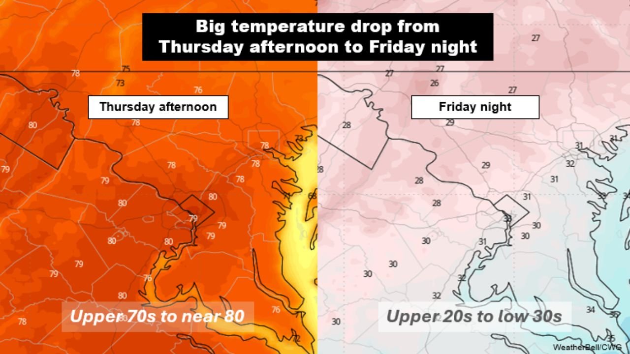
WASHINGTON, D.C. — A dramatic temperature plunge of nearly 50 degrees is set to impact Washington, D.C., Virginia, and Maryland, as a powerful cold front moves through the region from Thursday afternoon into Friday night. After highs reach the upper 70s to near 80°F Thursday, temperatures will steadily fall through Friday, eventually dropping into the upper 20s to low 30s overnight.
This sharp swing marks one of the most significant late-March temperature changes across the Mid-Atlantic region this season.
Warm Spring Temperatures Collapse Quickly Friday
The region will begin with mild to warm conditions Thursday afternoon, with temperatures across Washington, D.C., northern Virginia, and central Maryland climbing into the upper 70s and near 80°F. Even early Friday morning, many areas will still be hovering near or above 60°F.
However, as the cold front pushes through, temperatures will drop rapidly throughout the day. By around 10 AM Friday, readings are expected to fall into the 50s, followed by a continued decline into the 40s by mid to late afternoon.
This fast-moving transition will create a noticeable shift in conditions within just a few hours, making Friday feel dramatically different from the day before.
Near-Freezing Temperatures Return by Friday Night
The cooling trend will continue into Friday night, with lows expected to reach the upper 20s to low 30s across much of Washington, D.C., Virginia, and Maryland. This completes a roughly 50-degree drop from Thursday afternoon highs.
Such a sharp temperature change is significant for late March and could have impacts on early spring vegetation, outdoor plans, and overnight conditions.
Areas outside of urban centers may experience the coldest temperatures, especially where skies begin to clear and winds decrease overnight.
Rain and Gusty Winds Add to Friday’s Impact
Along with the temperature drop, the region can expect occasional showers throughout Friday, adding to the unsettled conditions. Rainfall totals are expected to remain relatively light, generally ranging from 0.1 to 0.5 inches, but will contribute to a cool and damp feel.
Winds will also increase behind the front, with gusts from the north reaching 20 to 30 mph, further enhancing the perception of colder air. The combination of rain, wind, and falling temperatures will make conditions feel much colder than actual readings.
These factors could also lead to reduced visibility and slick road conditions, particularly during periods of steady rain.
What This Means for the Mid-Atlantic Region
For residents across Washington, D.C., Virginia, and Maryland, this setup highlights the volatility of late-season weather patterns, where rapid shifts between warm and cold conditions are common.
The dramatic temperature drop, combined with wind and rain, could impact daily routines, especially for those commuting or spending time outdoors on Friday.
By the weekend, conditions are expected to stabilize, but the sharp transition serves as another reminder of how quickly weather can change during the transition from winter to spring.
As this strong cold front moves through the Mid-Atlantic, staying informed will be essential for navigating rapidly changing conditions. For more updates on regional forecasts, temperature swings, and severe weather patterns, visit ChicagoMusicGuide.com.