
Washington, D.C. Warms to 57° as Sunday Storm Brings Mainly Rain, With Slushy Snow Possible North and Northeast of the Beltway
WASHINGTON, D.C. — The nation’s capital just experienced its warmest day since January 7, with temperatures at Reagan National Airport (DCA) climbing to at least 57 degrees, setting the stage for a mainly rainy Sunday storm system that could still deliver a slushy coating of snow north and northeast of the city.
While the region enjoyed a brief taste of milder air, forecasters say the warmth is temporary, with a system arriving Sunday that looks to favor rain for the D.C. metro area, though some neighborhoods could see wintry surprises if conditions align just right.
Warmest Day Since Early January Brings a Brief Break From Winter
According to the latest station data from Washington National Airport (DCA), temperatures reached 57 degrees, marking the warmest reading since January 7, when highs peaked at 63 degrees. While Sunday’s warmth is unlikely to surpass that earlier 63-degree mark, it still represents a noticeable departure from the colder stretches that dominated much of late January and early February.
Daily records show that January featured several chilly days, with highs in the upper 30s and low 40s. The return to the upper 50s offered a welcome change for residents, outdoor diners, and event organizers across the metro region.
However, this warm-up is part of a transitional setup ahead of a developing storm that will begin influencing the Mid-Atlantic by Sunday.
Sunday Storm: Mainly Rain for D.C., But Track Still Matters
Forecast guidance indicates that the approaching Sunday system will bring primarily rain to Washington, D.C., especially during the daytime hours when temperatures remain above freezing. The system’s track and the timing of colder air will determine how far south any snow can push.
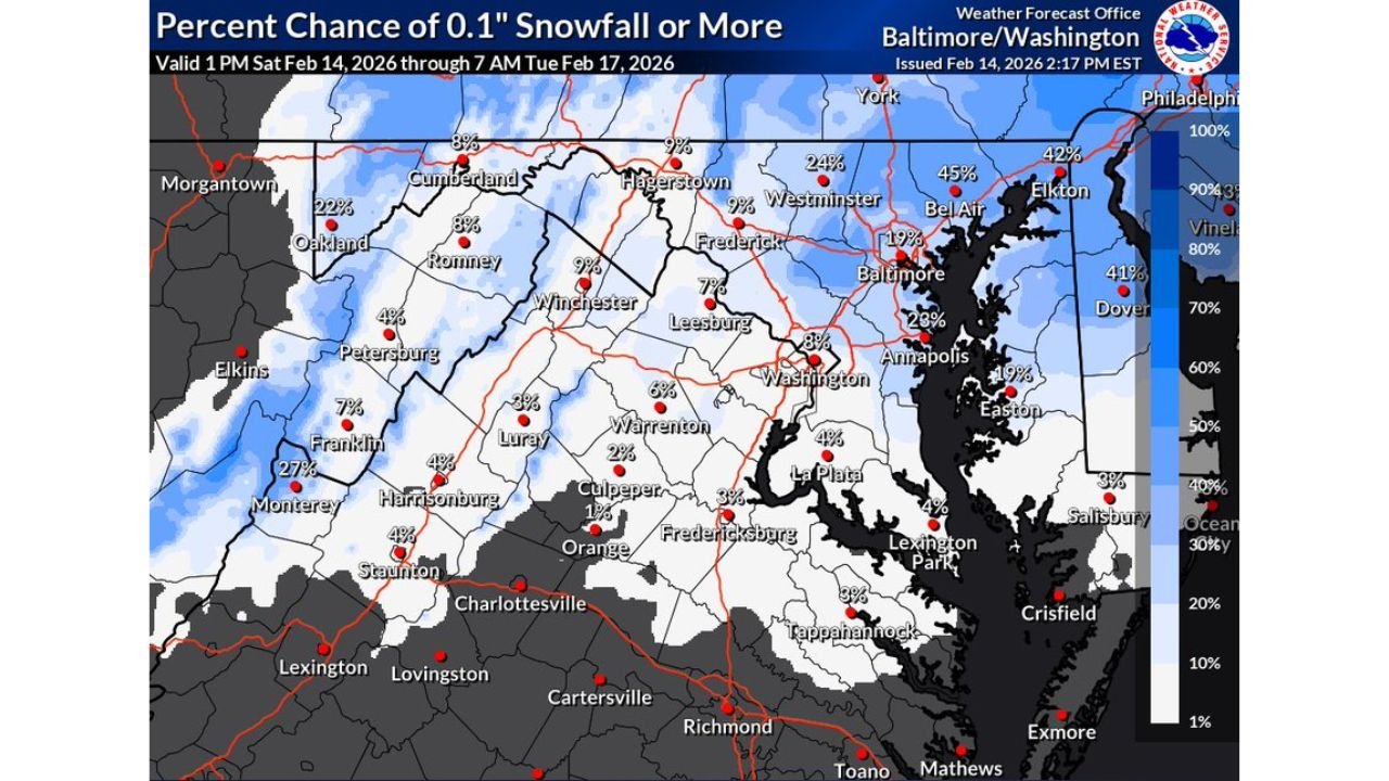
Probability maps show that the chance of 0.1 inches of snowfall or more increases north and northeast of D.C., particularly toward Baltimore, Bel Air, Elkton, and areas into southern Pennsylvania. In those locations, snow probabilities climb significantly compared to central D.C., where chances remain relatively low.
If colder air arrives more quickly and precipitation rates are heavy enough, a slushy dusting — or slightly more — could develop north and northeast of the Beltway. Areas along and south of the Potomac, however, are expected to see mostly cold rain.
Slushy Mix Most Likely in Northern Suburbs
Forecast discussions emphasize that the best chance for snow accumulation would be in elevated or inland areas, especially north of the city. Locations such as Frederick, Westminster, and parts of northern Maryland show higher snowfall probabilities on current guidance.
Still, forecasters caution that this is not a classic winter storm setup for downtown Washington. Ground temperatures remain marginal, and daytime warmth will make it difficult for snow to stick unless heavier precipitation cools the atmosphere rapidly.
Any accumulation that does occur would likely be slushy and short-lived, mainly on grassy surfaces and elevated areas. Major road impacts in D.C. itself appear unlikely at this time.
What This Means for Weekend Plans
For music lovers, outdoor venues, and event organizers in the D.C. area, Sunday plans may need to account for periods of rain and damp conditions. While widespread snow disruptions are not expected in the city, heavier rain bands could impact travel times and attendance.
Residents north and northeast of D.C. should monitor updates closely, especially if traveling into areas with higher snow potential.
The key takeaway: Washington, D.C. gets a mild interlude at 57 degrees before transitioning into a rainy Sunday, with only limited wintry potential outside the urban core.
Stay tuned to ChicagoMusicGuide.com for the latest weather updates affecting major cities, live events, and travel conditions across the country.