
Washington, D.C. Weekend Storm Could Bring Moderate Rain Sunday Into Monday, But Snow Chances Appear Low
WASHINGTON, D.C. — A potential weekend storm system is drawing attention across the Mid-Atlantic, but uncertainty remains high regarding its exact track and impact. Current guidance suggests that any precipitation in the Washington, D.C. area would likely fall between Sunday morning and Monday morning, though details are still evolving.
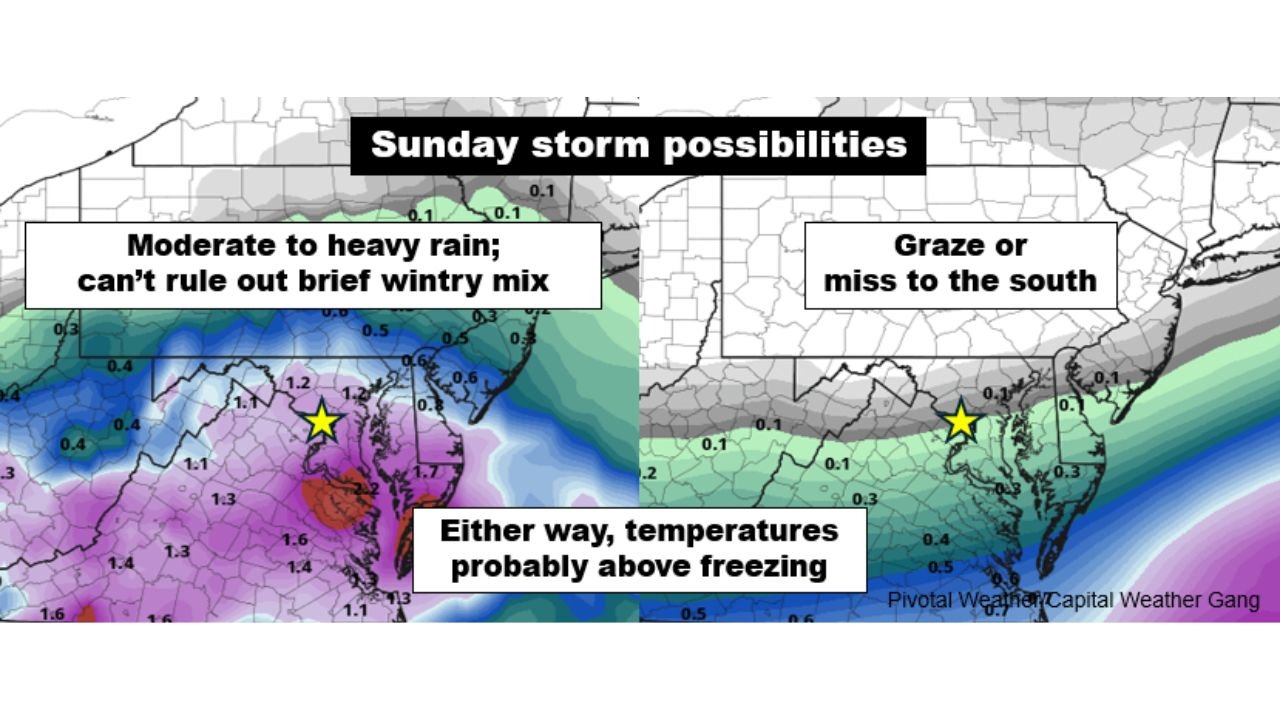
Forecasters emphasize that confidence remains low on the storm’s final outcome, with multiple scenarios still on the table.
Timing Window: Sunday Morning Through Early Monday
Model projections indicate that if the storm affects the region, precipitation would arrive sometime between Sunday morning and Monday morning. The system’s evolution and track will determine whether the D.C. metro area sees a steady rainfall event, a brief period of mixed precipitation, or minimal impacts.
Some model scenarios depict a swath of moderate to heavy rain pushing into the Mid-Atlantic, while others suggest the storm could graze the region or shift farther south.
A clearer forecast picture may emerge by midday Thursday, as higher-resolution model data becomes available.
Rain More Likely Than Snow
Confidence is increasing that surface temperatures will remain above freezing while precipitation is falling. Ground-level readings may climb into the 40s, significantly lowering the potential for impactful snow accumulation.
While a brief period of wintry mix or light snow cannot be completely ruled out in certain scenarios, especially during onset or transition phases, forecasters currently view the risk of meaningful accumulation as fairly low.
This temperature profile strongly favors rain over snow for most of the D.C. metro area.
Model Range: From Soaking Rain to Southern Miss
Forecast models currently range from producing an inch or more of liquid precipitation across parts of the region to scenarios where the storm shifts south, leaving Washington with little or no precipitation.
One potential outcome includes moderate to heavy rain across portions of the Mid-Atlantic, possibly accompanied by a short-lived mix. Another scenario shows the storm tracking farther south, largely bypassing the D.C. area.
Given these contrasting solutions, forecasters caution against locking in a single outcome too early.
What Residents Should Watch
For now, residents in Washington, D.C., northern Virginia, and central Maryland should monitor updates through the week. The primary impacts, if the wetter solution verifies, would involve:
- Steady rain Sunday into early Monday
- Reduced visibility during heavier rainfall
- Wet roadways during late weekend travel
At this time, significant winter accumulation appears unlikely due to above-freezing temperatures.
As uncertainty continues surrounding this potential weekend storm in the Mid-Atlantic, staying informed will be critical for travel plans and event scheduling. For continued national weather updates and coverage on how evolving systems may impact concerts, festivals, and live gatherings, visit ChicagoMusicGuide.com.