
Washington, Oregon, Montana and Colorado Finally Get Cooler Temperatures and Mountain Snow This Week but the Historic Snowpack Crisis Across the West Will Not See Meaningful Relief
DENVER, CO — The western United States has been baking through a historic heat wave for most of March — and the pattern change that forecasters have been watching for is now finally arriving. By Tuesday April 1st, a dramatically different atmospheric setup will take hold across the West, delivering much cooler temperatures and meaningful precipitation across portions of the Pacific Northwest, northern Rockies and higher mountain elevations. It will feel like a genuine reset after one of the warmest Marches on record across the region. But there is an important caveat that residents and water managers across the West need to understand clearly: this pattern change will not meaningfully fix the historic snowpack crisis that has been building all winter across the western mountains.
What the Pattern Change Is Bringing
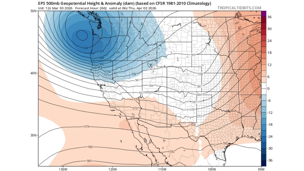
The EPS 500mb Geopotential Height and Anomaly map, initialized 12z March 30, valid at 06z April 2, shows the atmospheric mechanism driving this pattern change in stark visual terms. A massive, deep upper-level trough — shown by the deep blue anomaly zone covering the Pacific Northwest and western Canada — is rotating into position over the northwestern United States by Thursday. The blue shading represents heights significantly below normal at this level — cold air aloft, descending southward from the Arctic and sweeping across the Pacific Coast states.
The deepest blue on the map — centered over the Pacific Northwest and British Columbia — shows height anomalies running 18 to 36 units below the 1981-2010 climatological normal for early April. This is a substantial cold air intrusion for the time of year. The tightly packed height contours across the western states indicate strong upper-level winds rotating around the base of this trough — the kind of atmospheric forcing that drives active precipitation across the mountains and brings sharp temperature drops to areas that have been far above normal for weeks.
Meanwhile, the peach and pink positive height anomalies across the central and eastern United States — representing above-normal heights — continue the warm pattern that has been dominating those regions. The sharp contrast between the cold western trough and the warm eastern ridge is exactly the kind of amplified pattern that drives the jet stream into a strong west-to-east orientation across the northern tier, enhancing precipitation along the Cascades, northern Rockies and into the northern Plains.
What the 7-Day Precipitation Map Shows for the West
The EPS Total Accumulated Precipitation map from 12z March 30 through 12z April 6, 2026 shows where the precipitation associated with this pattern change is expected to fall across the western United States.
The Pacific Northwest — western Washington and Oregon shows the deepest blue shading on the western precipitation map, indicating the highest accumulations of the period for the region. This is consistent with the trough position — systems coming off the Pacific will deposit the heaviest moisture across the coastal ranges and western Cascades first before tracking inland.
Northern Idaho, western Montana and the northern Rockies show moderate blue precipitation shading — meaningful accumulations for these mountain ranges that have been running well below normal for snowpack all winter. At higher elevations, much of this precipitation will fall as snow — adding some accumulation to the mountain snowpack even if it does not reverse the deficit.
Colorado and the central Rockies show lighter green shading — precipitation is in the forecast but totals are more modest than for the Pacific Northwest and northern Rockies. The trough’s primary energy tracks further north, leaving Colorado on the drier southern edge of the precipitation corridor.
The southern and central Plains — Texas, Oklahoma, Kansas show minimal precipitation in this map — consistent with the active severe weather pattern playing out across those states this week through storms rather than steady widespread rainfall.
Why This Pattern Change Will Not Fix the Snowpack Crisis
Here is the honest reality check that residents across the West need to hear alongside the welcome news of cooler temperatures and mountain snow.
The Upper Colorado Basin snowpack currently sits at the 0th percentile — the lowest in recorded history for this time of year across 130 monitoring sites. The western mountain snowpack has been running 27% to 30% of median values heading into what should be the final weeks of the accumulation season. The median peak snowpack date is approximately April 6th — meaning the window for meaningful snowpack accumulation is essentially closing.
To recover from a 0th percentile snowpack to even a below-normal level would require an extraordinary and sustained series of snowstorms across the mountains — the kind of multi-week wet pattern that does not happen in April and May in the western United States under normal atmospheric conditions.
What this pattern change delivers is real but limited. Some additional snow at higher elevations. A meaningful temperature cooldown that at least slows the rate of early melt. A brief respite from the brutal warmth that accelerated snowpack loss through March. These are genuinely positive developments — but they will not meaningfully ameliorate the now-historic low snowpack conditions across the western mountains.
Lakes Powell and Mead — the two largest reservoirs in the country that supply water to over 40 million people across seven states — will still face a near-record low inflow year in 2026 regardless of what happens over the next two weeks. The math simply does not work. The snowpack deficit is too large and the season is too advanced for a single pattern change to reverse it.
Western Pattern Change Summary Table
| Region | Temperature Change | Precipitation Signal | Snowpack Relief |
|---|---|---|---|
| Pacific Northwest — WA, OR | 🔵 Much Cooler | 🔵 Moderate-High | 🟡 Limited — adds some |
| Northern Rockies — MT, ID | 🔵 Much Cooler | 🔵 Moderate | 🟡 Limited |
| Colorado and Central Rockies | 🔵 Cooler | 🟡 Light-Moderate | 🔴 Minimal |
| California | 🔵 Cooler | 🟡 Light | 🔴 Minimal |
| Upper Colorado Basin Overall | Cooler but too late | Some mountain snow | 🔴 Will NOT fix 0th percentile deficit |
| Lakes Powell and Mead Outlook | — | Near-record low inflow likely | 🔴 Not changed by this event |
State-by-State Western Impact
🔵 Washington and Oregon — The biggest beneficiaries of this pattern change in the western United States. Seattle, Portland and the Cascade Range will see the most dramatic temperature drops and the most significant precipitation from this trough. Mountain snowpack additions in the Cascades will be the most meaningful of any range in the western U.S. from this event.
🔵 Montana and Idaho — Billings, Missoula, Boise and the surrounding mountain corridors will see meaningful temperature drops and mountain snow accumulations. The northern Rockies get the best precipitation signal of the interior West states from this pattern change.
🟡 Colorado — Denver, Boulder and the Front Range will feel significantly cooler temperatures — a welcome change after the warmth of March. Mountain snow is possible across the high terrain but totals will be more modest than for the Pacific Northwest. The 0th percentile snowpack in the Upper Colorado Basin will not be meaningfully improved by this event.
🟡 Utah and Nevada — Cooler temperatures arriving but precipitation signal is lighter than for states further north. The Great Basin sits on the drier side of this trough’s precipitation footprint.
🟡 California — Northern California and the Sierra Nevada will see some precipitation and cooler temperatures. Southern California remains on the dry, warm side of the pattern.
🟢 Arizona and New Mexico — Minimal direct impact from the trough. Temperatures will moderate slightly but the extreme drought conditions across both states will see little to no precipitation relief from this pattern change.
The Bottom Line: Welcome Relief, Limited Impact on the Big Problem
This pattern change is genuinely good news for the West after an exhausting March of historic heat. Cooler temperatures, mountain snow and Pacific precipitation are all real and positive developments. Enjoy the relief — it has been a long time coming.
But the water supply crisis across the Colorado River Basin, the 0th percentile snowpack across the Upper Colorado and the near-record low inflow forecast for Lakes Powell and Mead are problems that a two-week weather pattern cannot solve. Those challenges will define the summer of 2026 across the western United States regardless of what the atmosphere delivers in April.
The West Is Finally Getting a Break From the Heat but the Water Crisis That March Built Will Last Through Summer
More pattern updates and snowpack analysis are ahead as the western water situation develops through spring. Stay informed at ChicagoMusicGuide.com — your source for western drought coverage, snowpack data and pattern change analysis across Washington, Oregon, Colorado, California and the entire United States.