
Washington State and Pacific Northwest Could Face Rare Multi-Threat Storm With Heavy Snow, 70 MPH Winds and Atmospheric River, Model Shows
PACIFIC NORTHWEST — Long-range weather models are hinting at a powerful and complex storm system that could impact Washington State and the broader Pacific Northwest in roughly 9 to 11 days, potentially bringing a rare combination of heavy snow, strong winds, and an atmospheric river event.
The scenario comes from a recent Global Forecast System (GFS) model run, which suggests an unusually dynamic weather setup developing over the region during the middle of March.
Meteorologists caution that forecasts this far out remain highly uncertain, but the model highlights how active the weather pattern across the Pacific Northwest could soon become.
Model Suggests Heavy Snowfall Near Seattle
One of the most striking elements of the model simulation is the possibility of significant snowfall across western Washington, including the Seattle area.
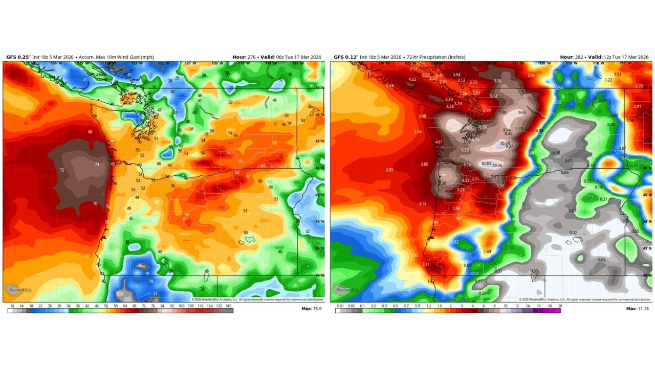
Snowfall projections from the model show more than a foot of snow possible in parts of western Washington, particularly across areas surrounding Puget Sound and nearby higher terrain.
Such a snowfall event would be unusual for mid-March in the region, though not impossible when strong Pacific systems interact with colder air.
Powerful Winds Could Follow the Snow
The same model run indicates the storm may rapidly intensify after the initial snowfall, bringing strong winds across Washington and Oregon.
Wind projections show the potential for gusts between 50 and 70 mph, particularly along coastal areas and exposed terrain across the Pacific Northwest.
These winds could create hazardous travel conditions and potentially lead to power outages if such a scenario were to occur.
Atmospheric River Could Bring Heavy Rain
Following the potential snowstorm and wind event, the model suggests warmer air could surge into the region, transforming the system into a strong atmospheric river setup.
Atmospheric rivers transport large amounts of Pacific moisture inland and can produce very heavy rainfall over a short period of time.
Model precipitation projections indicate the possibility of several inches of rain across Washington and Oregon, particularly along coastal regions and mountainous terrain.
Rapid Snow Melt Could Follow
If warmer air arrives quickly after a major snowfall, it could lead to rapid snowmelt combined with heavy rain, a setup that sometimes raises concerns for flooding in parts of the Pacific Northwest.
However, meteorologists stress that this scenario remains highly speculative because the forecast is still more than a week away.
Active Weather Pattern Expected
While the specific model solution showing a major snowstorm and atmospheric river combination is considered unlikely at this time, forecasters do expect an increasingly active weather pattern across the Pacific Northwest in the coming weeks.
This could bring multiple storm systems capable of producing rain, mountain snow, and gusty winds across Washington, Oregon, and surrounding areas.
As newer model runs become available, meteorologists will gain a clearer picture of whether a significant storm system could develop.
For continued coverage of major weather developments across the United States, follow updates from ChicagoMusicGuide.com.