
Washington State Braces for Dangerous Flooding as 8–12 Inches of Additional Rainfall Targets the Cascades and Coastal Range
WASHINGTON STATE — A Major Flood Emergency is Building With the Heaviest Rainfall Still Ahead, Washington State is entering one of its most dangerous stretches of the winter season, with meteorologists warning that the worst flooding has not yet arrived. After multiple days of nonstop rainfall, new model data shows another 4–12 inches of additional precipitation poised to hit the region through Friday, creating a high-risk setup for rapidly worsening river flooding, landslides, and widespread travel disruptions.
The Coastal Range and Cascades — already saturated — are expected to receive the most intense impacts, while metro areas like Seattle and Portland are also forecast to see 2–3 inches of new rainfall, adding to the strain on local waterways.
Most Impacted Regions: Coastal Range, Cascades, and Northwest Oregon
Forecast maps indicate a highly uneven rainfall distribution, with the heaviest bands concentrated across elevated terrain:
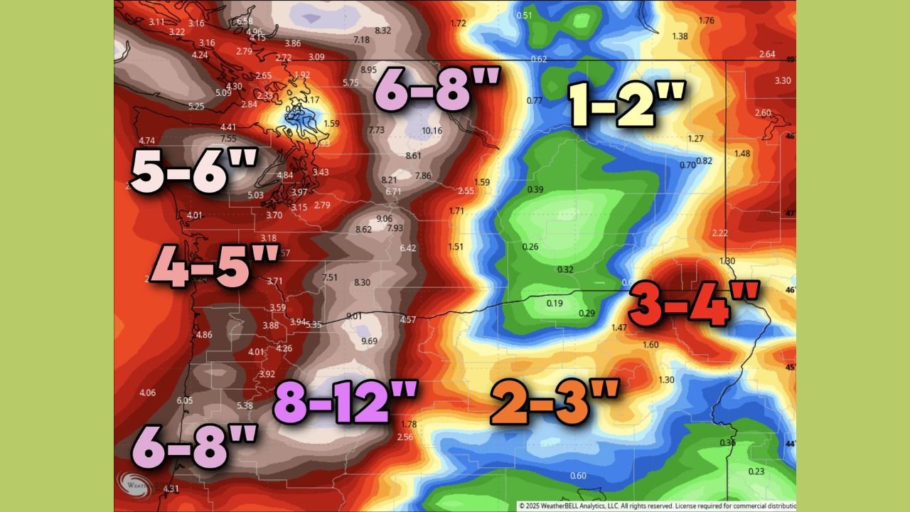
- Cascades: 8–12 inches
- Coastal Range: 5–6 inches, locally 6–8 inches
- Western Washington lowlands: 4–5 inches
- Seattle metro: 2–3 inches
- Portland/Vancouver area: 2–3 inches
- Eastern Washington: Much lighter totals, 1–2 inches
These exceptional rainfall rates are being driven by a persistent plume of Pacific moisture that continues to funnel inland.
Rivers Facing Rapid Rises: Nooksack, Snohomish, Skagit
Hydrologists are warning that several major rivers are likely to reach serious or major flood stage in the days ahead:
- Nooksack River
- Snohomish River
- Skagit River
With soil already saturated and snow levels remaining high — limiting snowpack absorption — runoff will enter waterways quickly. Flash flooding, road washouts, and isolated evacuations are possible in the hardest-hit basins.
Storm Setup: Why the Rainfall Is Intensifying
This week’s pattern is being driven by a deep and persistent Pacific storm track sending multiple moisture-rich disturbances into the Pacific Northwest. Each wave is reinforcing the next, producing a prolonged heavy-rain event instead of isolated storms.
Key contributors include:
- A strong atmospheric river stream feeding continuous moisture into the region
- Warm Pacific air keeping snow levels elevated, increasing runoff
- Repeated storm impulses targeting the same locations day after day
The overlap of these ingredients is what makes this event particularly dangerous.
Urban Impacts: Seattle and Portland Prepare for Additional Flooding
While totals are lower than in the mountains, metro regions around Puget Sound and northwest Oregon will still face concerns:
- Urban flooding in low-lying neighborhoods
- Storm drain overload due to high rainfall rates
- Slippery, hazardous travel, especially during peak commuting hours
Even 2–3 inches of additional rain over major cities already dealing with saturated soil can cause significant strain on infrastructure.
Travel Impacts Expected Through Friday
Heavy rainfall and rising river levels may lead to:
- Road closures along mountain passes
- Potential mudslides in steep terrain
- Reduced visibility and hazardous driving
- Ferry delays or schedule adjustments
- Localized power outages in rural areas
Residents planning holiday travel should stay alert for rapidly changing conditions.
Stay Updated and Stay Safe
With flooding risks growing and more heavy rain on the way, Washington residents should monitor alerts closely and avoid flooded roadways. ChicagoMusicGuide.com will continue to track major national weather developments to keep readers informed.