
Washington State Braces for Widespread 50–75 MPH Wind Gusts as Powerful Storm Targets the Pacific Northwest
WASHINGTON STATE — A rapidly strengthening storm system is moving toward the Pacific Northwest, bringing the threat of widespread 50–75 mph wind gusts across western Washington. Forecast models show damaging winds spreading into several communities within hours, creating hazardous conditions for residents from the coast to the interior lowlands.
Widespread Strong Winds Expected Across Western Washington
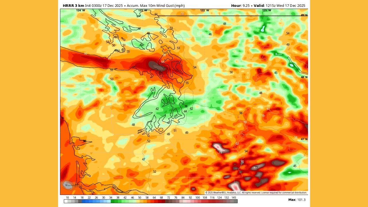
New HRRR model guidance highlights a broad area of 50 mph wind gusts extending across much of western Washington, including the greater Seattle region and cities along the Interstate-5 corridor. Higher terrain interaction and funneling through coastal gaps are expected to enhance wind speeds significantly.
Areas including Joyce, Port Angeles, Sequim, Port Townsend, Oak Harbor, Everett, and Edmonds appear positioned for 55–75 mph gusts, with the strongest winds focused along the Strait of Juan de Fuca. These conditions raise the likelihood of downed trees, scattered power outages, and rapidly deteriorating travel conditions.
Atmospheric Setup Supporting Rapid Wind Intensification
Forecast data shows the storm system strengthening under a powerful jet stream, tightening the pressure gradient across Washington. This setup enhances wind acceleration as air rushes toward the deepening low-pressure center offshore.
Model projections also indicate gusts in the 60–70 mph range over southwest Washington and portions of northwest Oregon, suggesting a broader regional wind event that will affect multiple counties simultaneously.
Expected Impacts: Power Outages, Travel Hazards, and Tree Damage
With the landscape already weakened by multiple recent storms, the risk of infrastructure impacts is elevated. Residents should prepare for:
- Tree damage and falling limbs
- Widespread or extended power outages
- Ferry delays and potential cancellations
- Difficult driving on bridges and exposed roads
Coastal communities and areas near the strait are especially vulnerable to sudden, severe gusts.
Timing: When the Strongest Winds Will Hit
Based on current model trends:
- Western Washington: Gusts of 50–65 mph are expected to develop late Tuesday night
- Strait of Juan de Fuca and North Interior: Peak gusts 60–75 mph early Wednesday morning
- Southwest Washington & Northwest Oregon: Gusts 50–65 mph Wednesday morning
Winds are expected to weaken gradually by midday Wednesday as the system moves inland.
NWS Advisories and Public Safety Guidance
The National Weather Service has issued Wind Advisories and High Wind Warnings for many counties across western Washington. Additional updates or expanded warnings are possible as the storm approaches.
Residents are urged to:
- Secure outdoor items
- Charge essential electronics
- Avoid unnecessary travel during peak gust periods
- Monitor official alerts for changing conditions
Stay Updated With Chicago Music Guide
We will continue to monitor developments across Washington as this storm progresses and provide further updates if wind forecasts increase or impact zones shift. Stay connected for ongoing coverage of significant U.S. weather events.