
Washington State Faces Powerful Wind Event as 40–60 MPH Gusts Threaten Seattle Area, With Isolated Gusts Near 80 MPH in Western Interior
WASHINGTON — A significant wind event is expected to impact western Washington on Wednesday afternoon and evening, with damaging wind gusts ranging from 40 to 60 mph forecast across the Seattle metropolitan area and surrounding communities. Weather model data indicates that localized gusts could approach or exceed 80 mph in parts of the western interior and foothill regions, raising concerns about travel disruptions, power outages, and infrastructure damage.
Forecasters emphasize that this system has the potential to rival some of the strongest wind events seen in the region in recent years, particularly given Seattle’s typically sheltered geography.
Wind Impacts Expected Across the Puget Sound Region
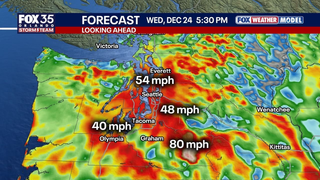
The strongest winds are expected to develop Wednesday afternoon and intensify into the evening hours. Forecast guidance highlights the following potential gusts across western Washington:
- Seattle: Gusts near 48 mph, with the potential for higher localized bursts
- Everett: Gusts approaching 54 mph
- Tacoma: Wind gusts near 48 mph
- Olympia: Gusts around 40 mph
- Western foothills near Graham: Isolated gusts possibly reaching 80 mph
Meteorologists note that gusts above 60 mph within Seattle itself are rare, due to the city’s protected location between terrain and waterways. However, the strength and orientation of this system could allow winds to briefly rival past events, especially in exposed areas and higher elevations.
Historical Context Highlights the Rarity of This Event
For comparison, February 2025 saw a recorded wind gust of 52 mph at Seattle-Tacoma International Airport, while Hoquiam recorded a 64 mph gust during that same event. Current projections suggest this upcoming system could match or exceed those values in select areas, particularly outside the urban core.
This combination of strong gradients and terrain-enhanced wind flow makes the event notable, even by Pacific Northwest winter standards.
Travel Disruptions and Airport Delays Possible
Transportation impacts are a major concern as winds peak during the late afternoon and evening commute. Officials warn that major delays — and even cancellations — are possible at Seattle-Tacoma International Airport, especially if gusts exceed operational thresholds for aircraft ground handling.
Drivers across western Washington should also prepare for downed trees, falling branches, and hazardous crosswinds, particularly on bridges, elevated roadways, and north–south routes.
Power Outages and Property Damage Risks
With saturated soils from recent weather systems, strong wind gusts increase the likelihood of trees uprooting, which could lead to power line damage and localized outages. Utility crews are expected to be on standby, but residents are advised to secure outdoor items and prepare for possible interruptions.
Emergency officials recommend charging devices ahead of time and avoiding unnecessary travel during the peak wind window.
What Happens Next
Winds are expected to gradually ease overnight into early Thursday, though breezy conditions may linger into the morning hours in some areas. Forecast confidence remains high that western Washington will experience impactful winds, even if exact gust locations vary.
Residents are encouraged to monitor local alerts and forecasts as conditions evolve.
For continued weather updates, regional impact breakdowns, and safety guidance, stay connected with ChicagoMusicGuide.com and join the conversation by sharing how conditions are developing in your area.