
Widespread Severe Weather Is Expected Across Iowa, Missouri, Illinois and Indiana on Thursday With Large Hail and Damaging Winds the Primary Threats and a Few Tornadoes Possible Across the Northern Part of the Risk Zone
CHICAGO, IL — Thursday’s severe weather threat just got its clearest picture yet — and the red oval now drawn across the map covering Iowa, Missouri, Illinois, Indiana and southern Michigan is not a preliminary signal anymore. It is a confirmed, data-backed severe weather watch area that puts millions of people across the Midwest on notice for an all-hazard severe weather day. The latest model data is showing enough instability across the region to support widespread severe storm development — with large hail and damaging winds locked in as the primary threats and a few tornadoes possible, particularly across the northern portion of the outlined risk zone.
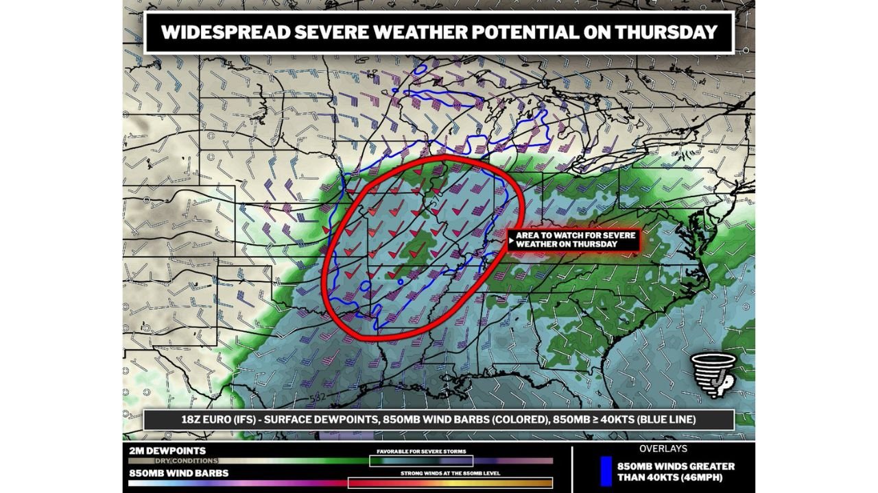
What the Map Is Showing for Thursday
The 18z Euro IFS surface dewpoint and 850mb wind analysis for Thursday shows a compelling and clearly organized severe weather setup across the central Midwest. Two atmospheric layers of data are overlaid on this map — and both are pointing in the same direction.
Surface dewpoints — shown in the green and teal shading — represent the moisture available at ground level. The favorable green zone for severe storms covers the entire red oval area, confirming that Gulf moisture is in place across Iowa, Missouri, Illinois and Indiana heading into Thursday. Dewpoints across the risk zone are running in the range that supports robust thunderstorm development and significant hail production in stronger cells.
850mb wind barbs — the colored wind arrows plotted across the map — show the wind speed and direction at roughly 5,000 feet above the surface. The red and purple wind barbs inside and around the red oval indicate winds running 40 knots or greater at this level — a signal of meaningful low-level wind shear. The blue line on the map outlines the zone where 850mb winds exceed 40 knots (46 mph) — and that blue line cuts directly through the northern portion of the red risk oval across Iowa, northern Illinois and southern Michigan.
That blue 40-knot wind boundary is the key to understanding where the tornado threat is highest on Thursday. Low-level jet stream winds of 40+ knots create the rotational environment that allows supercell thunderstorms to produce tornadoes. Where those winds are strongest — across the northern tier of the risk zone — the tornado potential is elevated above the rest of the area.
The Three Threats and How They Rank for Thursday
The data is now clear enough to rank Thursday’s threats in order of likelihood and geographic extent.
Large hail is the highest-confidence threat across the entire risk zone. The instability signal is strong — enough atmospheric fuel exists across Iowa, Missouri, Illinois and Indiana to support storm updrafts capable of suspending large hailstones for extended periods before they fall. Any storm that develops in the warm sector on Thursday will have the potential to produce hail, and some of that hail will be large enough to cause serious damage to vehicles, roofs and crops.
Damaging winds are the second primary threat and the one with the most widespread potential geographic reach. As storms organize into clusters or squall lines during Thursday afternoon and evening, straight-line wind gusts of 60 mph or higher become the dominant threat across the broadest area. Wind damage from squall lines is often more spatially widespread than either hail or tornado damage — and with saturated soils across much of this region from recent rainfall, the tree-down and power outage potential from 60+ mph gusts is elevated.
Tornadoes are possible but not the headline threat for most of the risk zone. The wind shear across the region is present but the question is whether it is sufficient to support widespread tornado-producing supercells. The honest assessment is that this does not look like a widespread tornado outbreak — but a few tornadoes will be possible, and the probability of those tornadoes is highest across the northern tier of the red oval where the 850mb winds are strongest and the low-level wind shear is most favorable.
Thursday Severe Weather Threat Table
| Threat | Risk Level | Primary Zone | Confidence |
|---|---|---|---|
| Large Hail | 🔴 High | Entire red oval — IA, MO, IL, IN | High |
| Damaging Winds 60+ mph | 🔴 High | Entire red oval | High |
| Tornadoes | 🟠 Moderate — Few Possible | Northern risk zone — N. IL, Iowa, S. Michigan | Moderate |
| Storm Initiation | 🟠 Moderate-High | Warm sector — afternoon hours | Moderate-High |
| SPC Official Outlook | Expected overnight | Full risk area | Pending |
State-by-State Impact for Thursday
🔴 Illinois — Chicago, Rockford, Peoria, Springfield — The entire state of Illinois from the Iowa border to the Indiana line falls inside the red severe weather oval. Chicago and the northern Illinois corridor sit inside the 40-knot 850mb wind zone — placing the Chicago metro in the elevated tornado risk portion of Thursday’s threat area. This is a day where Chicago residents need active weather alerts before the afternoon hours begin.
🔴 Iowa — Des Moines, Cedar Rapids, Davenport — Iowa sits at the northern edge of the instability zone and directly inside the strongest low-level wind shear on the map. The combination of sufficient instability and 40+ knot 850mb winds across Iowa creates the most favorable tornado environment of any state in the risk zone on Thursday. Des Moines and the I-80 corridor are the primary areas to watch.
🔴 Indiana — Indianapolis, Fort Wayne, Evansville — The entire state falls inside the red oval. Indianapolis and central Indiana sit in the warm sector where instability is highest and hail production will be most significant. Damaging winds are the highest-confidence threat for Indiana communities.
🔴 Missouri — Kansas City, St. Louis, Springfield — Missouri sits in the southern portion of the red oval where instability is richest. St. Louis and the Kansas City metro face large hail and damaging wind threats Thursday afternoon. The tornado risk for Missouri is lower than for the northern tier states but not zero.
🟠 Michigan — Detroit, Kalamazoo, Grand Rapids — Southern Michigan sits on the northeastern edge of the red oval. The Detroit metro and the I-94 corridor face severe weather potential Thursday evening as storms track northeast out of Indiana and Illinois. The 40-knot wind boundary clips southern Michigan, keeping a tornado threat in play for this region.
🟠 Wisconsin — Milwaukee, Madison, Green Bay — On the northern fringe of the risk area. Milwaukee and southern Wisconsin face severe weather potential if storms track northeast through Illinois and into the state during Thursday evening hours.
🟡 Kentucky and Tennessee — Southern fringe of the warm sector. Severe weather possible along the Ohio River corridor but confidence is lower than for the core Midwest states.
The One Thing That Could Change This Forecast
Wind shear is the variable that will ultimately determine whether Thursday becomes a widespread hail and wind event or whether it also produces a significant tornado threat across the northern risk zone.
The instability is confirmed — there is enough atmospheric fuel for severe storms across the entire red oval. What is still being evaluated is whether the wind shear profiles across Iowa, northern Illinois and southern Michigan will be sufficient to support long-lived, rotating supercells capable of producing significant tornadoes. If wind shear is stronger than currently modeled, the tornado threat escalates. If it is weaker, the event becomes primarily a hail and damaging wind day with only brief, isolated tornado spin-ups.
The SPC will issue its Thursday outlook overnight — and that official risk designation will be the clearest signal yet of where forecaster confidence lands on the tornado question heading into the event.
What Residents Across the Risk Zone Should Do Tonight
If you live in Chicago, Des Moines, Indianapolis or St. Louis — tonight is the right time to confirm your severe weather plan for Thursday. Review where your shelter is. Make sure weather alerts are active on every phone in your household. If you have outdoor property — furniture, trampolines, lightweight structures — secure them before Thursday morning.
Thursday afternoon is the primary window for severe storm development across the Midwest. If you are commuting or have afternoon plans anywhere inside the red oval, keep a weather app open and monitor conditions actively from noon onward.
Thursday Is the Most Widely Impactful Severe Weather Day of the Week for the Midwest and Millions of Residents Are Inside the Risk Zone
The storm system is coming — and it is coming for a broad swath of the most populated corridor in the central United States. Stay informed at ChicagoMusicGuide.com — your source for severe weather outbreak tracking, hail and tornado alerts and storm coverage across Illinois, Iowa, Indiana, Missouri and the entire United States.