
Wildfire Danger Rises Across Pennsylvania This Afternoon as Gusty Winds and Critically Low Humidity From Philadelphia to Pittsburgh Create Dangerous Conditions Statewide
HARRISBURG, PA — A dangerous combination of gusty winds and critically dry air is pushing Pennsylvania into elevated wildfire spread territory this afternoon, and state forecasters are issuing a clear and direct message to every resident from Pittsburgh to Philadelphia: now is not the time for outdoor burning, and any source of sparks could have serious consequences before the day is over.
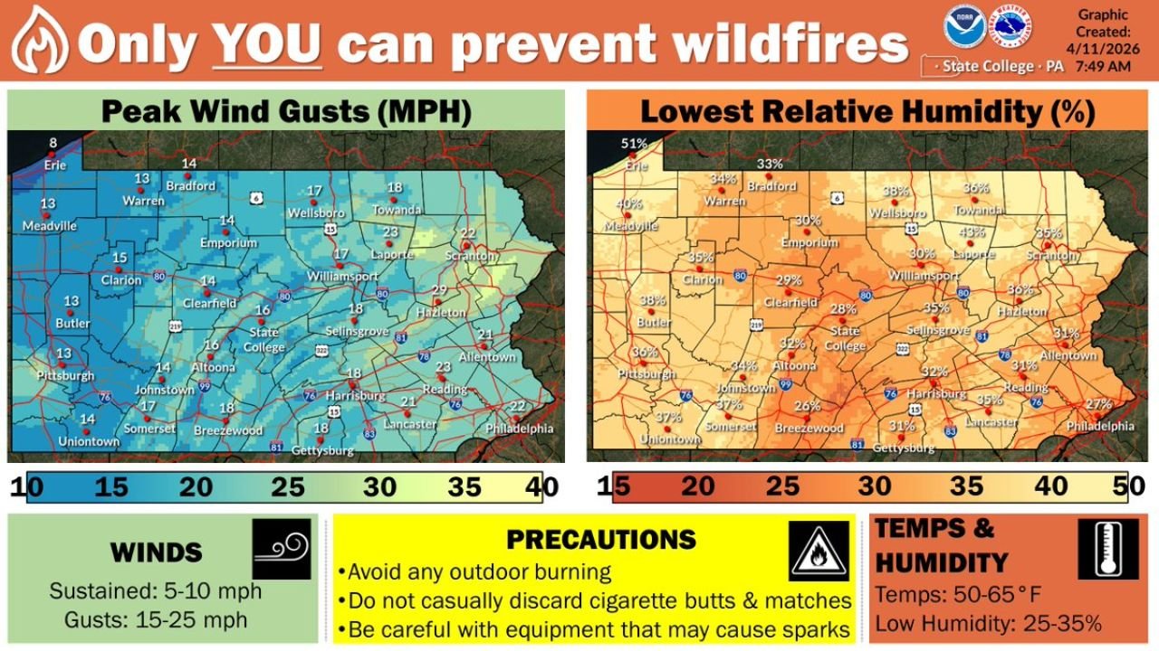
The conditions fueling this concern are straightforward and well-documented. Wind gusts across Pennsylvania today are forecast to reach 15 to 25 mph on top of sustained winds of 5 to 10 mph, while relative humidity — the measure of moisture in the air that acts as a natural brake on fire spread — is dropping to critically low levels of 25 to 35 percent across much of the state. Temperatures are running between 50 and 65 degrees Fahrenheit. When low humidity and gusty winds arrive together during a dry spring afternoon, the landscape becomes primed for rapid wildfire ignition and spread.
Wind and Humidity Data Across Pennsylvania
The peak wind gust forecast and lowest relative humidity readings tell the story of where the most dangerous fire weather conditions are concentrated today.
On the wind side, the highest gusts are focused across central and eastern Pennsylvania. Scranton leads the state with forecast peak gusts reaching 40 mph. Towanda is close behind at 23 mph, with Laporte at 22 mph, Allentown at 29 mph, Hazleton at 24 mph, and Selinsgrove at 21 mph. Moving across the central corridor, Williamsport is forecast at 17 mph, State College at 16 mph, and Clearfield at 16 mph. Western Pennsylvania sees the lightest winds today, with Pittsburgh at 13 mph, Butler at 13 mph, Clarion at 13 mph, and Erie at 8 mph on the northwestern edge.
On the humidity side, the driest conditions are concentrated across eastern and south-central Pennsylvania, where relative humidity values are forecast to drop to their most dangerous levels of the day. Philadelphia drops to just 27%, Reading at 31%, Lancaster at 31%, Allentown at 31%, and Harrisburg at 32%. Moving into the central corridor, Breezewood sits at 31%, Gettysburg at 31%, Selinsgrove at 32%, and Hazleton at 30%. Even the western communities that see lighter winds are not immune to the dryness — Pittsburgh drops to 34%, Butler to 38%, and Clarion to 35%.
Pennsylvania Fire Weather Data Summary
| Location | Peak Wind Gust | Lowest Relative Humidity |
|---|---|---|
| Scranton | 40 mph | 25% |
| Allentown | 29 mph | 31% |
| Philadelphia | 22 mph | 27% |
| Harrisburg | 18 mph | 32% |
| State College | 16 mph | 26% |
| Williamsport | 17 mph | 30% |
| Pittsburgh | 13 mph | 34% |
| Erie | 8 mph | 51% |
| Towanda | 23 mph | 28% |
| Lancaster | 18 mph | 31% |
What Pennsylvanians Need to Do Right Now
The official guidance issued alongside today’s fire weather data is direct and non-negotiable for anyone living across Pennsylvania this afternoon. Avoid any outdoor burning entirely — debris burning, brush piles, yard waste, and campfires all carry unacceptable ignition risk under today’s conditions. Do not casually discard cigarette butts or matches outdoors. Be careful with any equipment that may cause sparks, including lawn mowers, grinders, and chain saws operating near dry vegetation. Vehicles dragging chains on roadways or creating friction sparks on dry grass shoulders are a legitimate ignition concern on days like today.
The eastern half of the state — from Scranton and Towanda south through Allentown, Philadelphia, Harrisburg, and Lancaster — faces the most dangerous combination of high wind gusts and critically low humidity simultaneously. But no part of Pennsylvania is entirely free of fire weather risk this afternoon.
Forecast Confidence
Forecast Confidence: High. The wind and humidity values mapped today are based on current morning observations and short-range forecast guidance, placing high confidence behind the afternoon fire weather threat across Pennsylvania. Conditions are expected to peak during the warmest and windiest part of the afternoon before gradually easing toward evening as temperatures drop and humidity partially recovers.
More wildfire weather and fire danger coverage is always on the horizon. Stay informed at ChicagoMusicGuide.com — your source for fire weather tracking across Pennsylvania, the Mid-Atlantic, and the entire United States.