
Winter Is Not Done With the Northern United States as Model Data Shows Multiple Snow Chances Continuing Across the Dakotas, Minnesota, Wisconsin and Michigan All the Way Through Mid-April
BISMARCK, ND — While the central Plains are tracking severe thunderstorms and the Southeast is watching flood-producing rainfall, the northern tier of the United States is dealing with a completely different weather reality — and it has no intention of letting go of winter quietly. The latest long-range snow forecast through April 14, 2026 is showing a broad and persistent snow signal stretching from the Pacific Northwest eastward through Montana, the Dakotas, Minnesota, northern Wisconsin and the Upper Peninsula of Michigan — a corridor that is being told, unambiguously, that multiple more rounds of winter weather are coming before spring finally wins the battle across the northern United States.
What the Snow Forecast Is Actually Showing
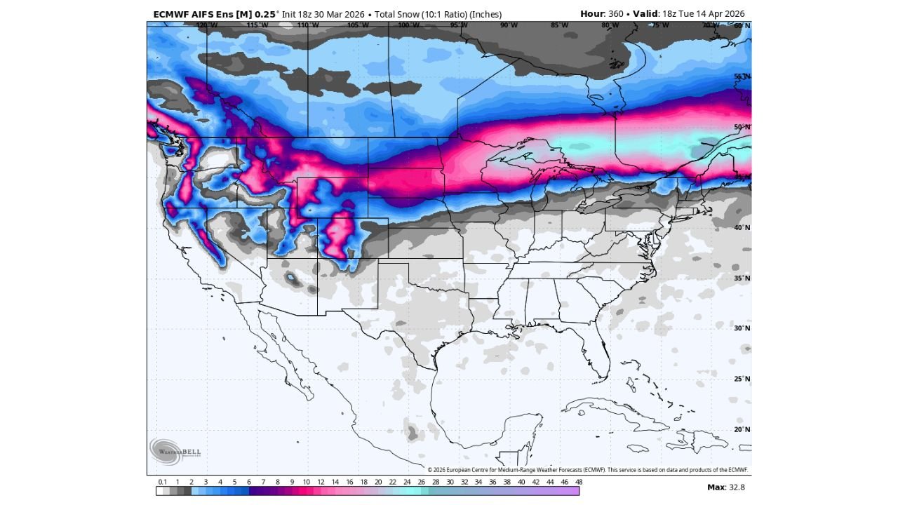
The ECMWF AIFS Ensemble at 0.25° resolution, initialized 18z March 30, 2026, valid through 18z April 14, 2026, shows the total snow accumulation signal across North America over a two-week period. The map is dominated by a striking band of blue and magenta — the colors representing the highest snow totals — running in a corridor from the northern Rockies and Pacific Northwest all the way east through the northern Plains and into the Great Lakes.
The maximum value on the map is 32.8 inches — located in the highest terrain of the northern Rockies and Cascades where orographic enhancement dramatically amplifies snowfall totals. But the more important signal for most residents is not the mountain maximum — it is the broad, persistent blue zone covering the Dakotas, Minnesota, northern Wisconsin and Michigan’s Upper Peninsula where meaningful snow accumulations are forecast across a wide, flat area over the next two weeks.
The key guidance from the data is this: look at the signal, not the specific numbers. At two weeks out, exact accumulation totals carry significant uncertainty — the atmosphere at 14-day range cannot be pinned down to a precise inch count. What the ensemble mean is confidently communicating is the signal — that this corridor will see several more rounds of snow chances through mid-April, not a single event. The blue and magenta shading represents a persistent, repeated snow pattern rather than one large storm.
Why the Northern Tier Is Still in Winter’s Grip
The contrast between what is happening across the northern tier and what is happening across the central and southern United States right now is one of the most striking atmospheric setups of early spring 2026.
While temperatures across the Plains, Southeast and West have been running well above normal — San Francisco just recorded its warmest March in 135 years and more than 1,100 daily temperature records were broken across the country in March — the northern tier has been locked in a completely different pattern. A persistent jet stream configuration has kept cold Arctic air flowing southward into the northern United States repeatedly through late winter and into early spring.
That same jet stream configuration is what is driving the continued snow chances through mid-April. The jet stream boundary between Arctic air to the north and warming spring air to the south is sitting squarely across the northern tier states — and every time a storm system tracks along that boundary, the northern side gets snow while areas to the south get rain and severe weather. This pattern explains why the Dakotas and Minnesota can be getting snow at the same time Oklahoma and Kansas are dealing with tornado-producing supercells.
The Magenta and Pink Signal: Where Snow Is Most Persistent
The magenta and pink shading on the ECMWF map — representing the highest total snow accumulations over the two-week period — is concentrated in three distinct zones.
The Pacific Northwest and northern Rockies show the deepest magenta shading, with the maximum value of 32.8 inches reflecting heavy orographic snowfall across the mountains of Washington, Oregon, Idaho and Montana. This is the primary mountain snowpack zone and the heavy totals here represent multiple storm systems riding in from the Pacific through mid-April.
The northern Plains corridor — running from eastern Montana through North Dakota and into northern Minnesota — shows a persistent band of blue shading with some localized magenta areas indicating the highest accumulation zones across the flatlands. For Bismarck, Minot and the surrounding communities, multiple rounds of snow through mid-April represent a meaningful winter weather persistence signal.
The Great Lakes northern tier — northern Wisconsin and Michigan’s Upper Peninsula — shows a second area of enhanced snow signal, where lake-effect and synoptic snow events combine to keep accumulations elevated through the mid-April timeframe.
Snow Outlook Summary Table
| Region | Snow Signal | Pattern Type | Timing |
|---|---|---|---|
| North Dakota, South Dakota | 🔵 Moderate-High | Multiple storm systems | Through April 14 |
| Minnesota — Northern tier | 🔵 Moderate-High | Repeated rounds | Through April 14 |
| Montana — Eastern plains | 🔵 Moderate | Multiple systems | Through April 14 |
| Northern Wisconsin | 🔵 Moderate | Synoptic and lake-effect | Through April 14 |
| Michigan Upper Peninsula | 🔵 Moderate-High | Lake-effect enhanced | Through April 14 |
| Northern Rockies and Cascades | 🟣 High — 20-32+ inches | Orographic enhancement | Through April 14 |
| Southern Plains — KS, OK, TX | ⬜ No snow signal | Severe weather pattern | Through April 14 |
| Overall Confidence | Signal strong — totals uncertain | Ensemble mean consistent | 🟠 Moderate |
State-by-State Winter Outlook Through Mid-April
🔵 North Dakota — Bismarck, Fargo, Minot — The state with the most persistent and consistent snow signal in the entire northern tier. Multiple rounds of snow are expected through April 14th. Residents and agricultural operations across North Dakota should not assume winter is over — the data says several more winter weather events are ahead.
🔵 South Dakota — Rapid City, Aberdeen, Sioux Falls — Inside the snow signal corridor. The western half of South Dakota, particularly near the Black Hills, faces the most significant accumulations from the pattern. Eastern South Dakota into the Sioux Falls area sees a lighter but still real snow chance signal through mid-April.
🔵 Minnesota — Duluth, International Falls, Bemidji — Northern Minnesota sits squarely inside the most persistent snow band on the map. Duluth and the Iron Range face multiple rounds of late-season snow through April 14th. The Minneapolis-St. Paul metro sits on the southern edge of the signal — not immune to late snow events but less persistently impacted than the northern tier communities.
🔵 Michigan — Upper Peninsula, Marquette, Sault Ste. Marie — The UP is highlighted by the enhanced snow signal on the map. Lake Superior’s temperature keeps lake-effect snow potential alive well into April, and the synoptic pattern is providing additional rounds of snowfall on top of any lake-effect contributions.
🔵 Wisconsin — Northern counties, Green Bay, Wausau — Northern Wisconsin falls inside the persistent snow corridor. Communities north of the I-90/I-94 corridor face continued winter weather chances through mid-April that residents in southern Wisconsin and the Milwaukee area will largely avoid.
🟡 Montana — Great Falls, Billings, Havre — Eastern Montana sits on the eastern edge of the heavy mountain snow zone. The plains areas of Montana see continued snow chances through mid-April, with totals lower than the mountains but still significant for agricultural and travel planning.
🟢 Nebraska, Iowa, Illinois — South of the primary snow corridor. The jet stream boundary keeps meaningful snow chances limited across these states through mid-April, though late-season cold outbreaks can occasionally push snow further south than the ensemble mean suggests.
What This Means for Residents and Agriculture
For the millions of people living across the northern tier — this forecast is a direct message that winter clothing, snow removal equipment and cold-weather preparations should not yet be put away. Multiple rounds of snow through mid-April means continued school delay and closure potential, travel disruption and agricultural planting delays across the Dakotas and Minnesota.
For farming operations across North Dakota and South Dakota — the persistent snow signal through mid-April has direct implications for spring planting timelines. Wet, snow-covered fields cannot be worked, and every additional snow event pushes the planting window further into late April and May. With the La Niña to El Niño transition already underway, the spring of 2026 is shaping up as a challenging one for northern Plains agriculture caught between a late winter and the approaching warmer season.
Winter Is Holding On Across the Northern United States and Mid-April Is the Earliest the Pattern Is Expected to Shift
Multiple more rounds of snow are ahead for the Dakotas, Minnesota, Wisconsin and Michigan. Stay informed at ChicagoMusicGuide.com — your source for late-season snow tracking, winter weather outlooks and pattern analysis across the northern United States and beyond.