
Winter Storm Threat Targets Texas, Oklahoma, Arkansas, Tennessee, Kentucky, Missouri, Illinois, Indiana and Ohio With Snow, Sleet and Dangerous Ice Next Weekend
UNITED STATES — A strengthening winter weather signal is emerging for a potentially impactful storm system expected to affect a large portion of the country next weekend, with multiple states facing the risk of heavy snow, sleet, and significant ice accumulation. Long-range ensemble guidance now consistently shows a classic cold-air-damming setup that could bring disruptive conditions from the Southern Plains through the Ohio Valley and into parts of the Midwest and interior East.
This is not a single-state event. The evolving pattern spans Texas, Oklahoma, Arkansas, Louisiana, Mississippi, Tennessee, Kentucky, Missouri, Illinois, Indiana, Ohio, and potentially portions of the Mid-Atlantic depending on how the system ultimately tracks.
A Classic Winter Storm Setup Is Taking Shape
Forecast guidance shows strong Canadian high pressure pushing south into the central United States while Gulf moisture surges northward. This creates a textbook overrunning scenario, where warmer, moisture-rich air rides over a shallow layer of subfreezing surface air.
When that happens, precipitation type becomes highly sensitive to small temperature changes. Snow develops on the cold side of the system, while areas just south and east of the snow band face a higher risk of sleet and freezing rain.
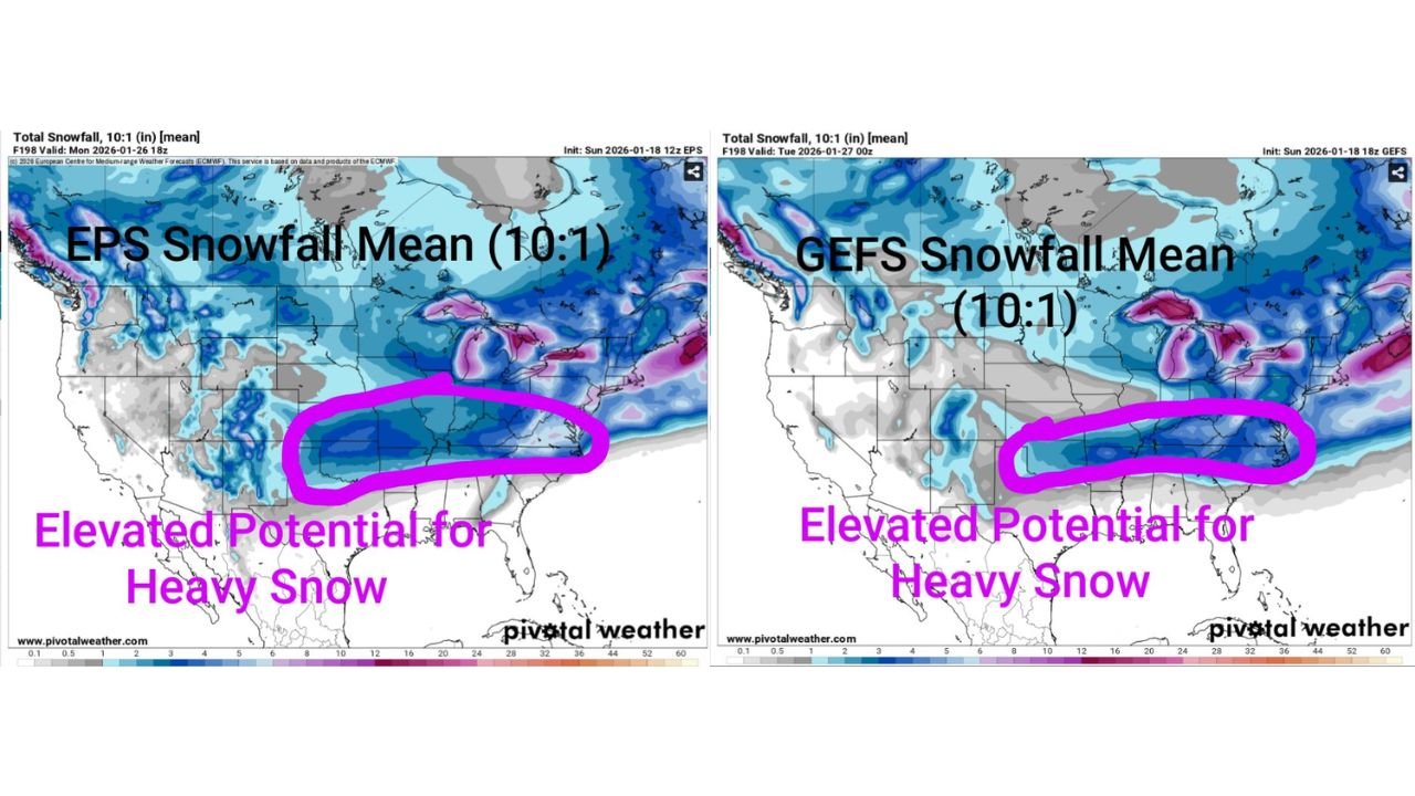
Ensemble means from both EPS and GEFS now highlight a broad corridor of winter precipitation stretching from the Southern Plains into the Midwest, increasing confidence that some form of impactful winter weather will occur.
Ice Storm Risk Focused on the South and Lower Midwest
One of the most concerning signals is the elevated freezing rain potential across parts of:
- Eastern Texas
- Oklahoma
- Arkansas
- Northern Louisiana
- Mississippi
- Tennessee
- Kentucky
EPS ensemble averages already suggest up to one-half inch of freezing rain in some areas. While exact placement is still uncertain 5–6 days out, even a fraction of that amount can cause serious impacts.
Ice accumulation of this magnitude is capable of:
- Snapping tree limbs
- Pulling down power lines
- Causing widespread power outages
- Making roadways impassable for extended periods
Travel during an ice storm is often impossible, and recovery can take days if infrastructure is damaged.
Heavy Snow Potential From the Plains Into the Midwest
On the colder side of the system, ensemble snowfall means indicate elevated potential for heavy snow across:
- Missouri
- Illinois
- Indiana
- Ohio
- Portions of Kansas and Iowa
Both EPS and GEFS guidance show a consistent snow corridor, with snow ratios potentially higher than average due to very cold air aloft. If the storm strengthens as projected, localized heavy accumulations could develop quickly, especially where mesoscale banding sets up.
The exact snow axis will depend heavily on how far north the surface low tracks and how strong the cold high remains over the Midwest.
Timing: What We Know and What We Don’t Yet
At this range, forecasters are focused on pattern recognition, not final totals.
7–10 days out
- The large-scale pattern supports winter weather potential
- No specific accumulation forecasts yet
5–7 days out
- Watching trends: Is guidance becoming more consistent or backing off?
- Confidence begins to increase or decrease
3–5 days out
- Precipitation type questions become clearer
- Snow vs sleet vs ice zones start to sharpen
1–3 days out
- Specific impacts, totals, and advisories can be confidently issued
Right now, this system firmly sits in the “possible but increasingly concerning” category.
Hazardous Cold Adds Another Layer of Risk
The Weather Prediction Center’s Day 3–7 Hazards Outlook highlights hazardous cold stretching from the Northern Plains into the Midwest, overlapping with areas expecting snow. Wind chills could plunge dangerously low in parts of the region, increasing the risk of frostbite and complicating travel and recovery efforts.
Cold air strength will be a major factor in determining just how far south snow and ice extend.
What Residents in Affected States Should Do Now
While there is no reason to panic, this is not a system to ignore.
- Begin monitoring daily forecast updates
- Review winter travel and power outage plans
- Stock up on basic non-perishable supplies if you live in ice-prone areas
- Avoid making rigid travel plans late next weekend
Forecasts will change, especially with temperature-sensitive systems like this one. Trends over the next several days matter far more than any single model run.
Bottom Line
A large, multi-state winter storm is increasingly possible next weekend, with snow threatening the Midwest and significant ice risk across parts of the South. Confidence is rising that winter weather will occur somewhere in this corridor — the remaining question is where the highest impacts ultimately land.
Stay tuned, stay flexible, and remember: long-range forecasts are about awareness, not alarms.
For continued updates on this developing winter threat and how it may affect travel, concerts, and events across the country, keep following ChicagoMusicGuide.com.