
Hawaii Soaked by Kona Low: Oahu, Maui, Kauai, and Big Island See 10+ Inches of Rain as Flash Flooding Continues Across the Island Chain
HONOLULU, HAWAII — A powerful Kona Low has drenched the Hawaiian Islands with extreme rainfall totals, with multiple locations across Oahu, Maui, Kauai, Molokai, Lanai, and the Big Island reporting 10 inches or more of rain over the past several days.
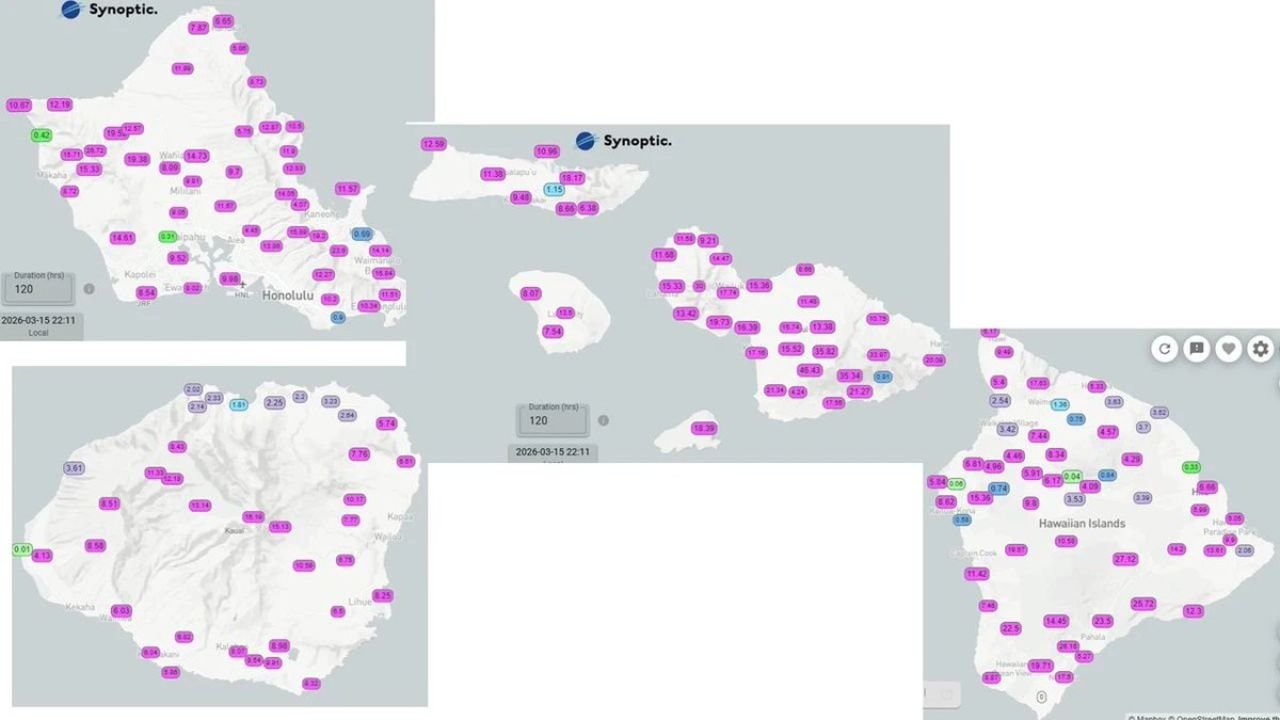
Rainfall data released by the National Weather Service in Honolulu shows widespread double-digit totals, particularly across elevated terrain and windward mountain slopes. Flash flooding has been ongoing in parts of the island chain, and additional heavy rainfall remains in the forecast.
Oahu: Widespread Double-Digit Totals
Across Oahu, rainfall amounts have exceeded 10 inches in numerous locations, especially in higher elevations and interior valleys.
Communities surrounding Honolulu, as well as areas toward the Koʻolau and Waianae mountain ranges, have seen substantial accumulation. The mountainous terrain has enhanced rainfall efficiency, funneling moisture upslope and intensifying totals.
Localized totals surpassing 12 inches were reported in some of the hardest-hit zones, contributing to rapid runoff and flood-prone conditions.
Maui County: Heavy Rain in Mountain and Leeward Areas
In Maui County, including Maui, Molokai, and Lanai, rainfall totals also climbed into the double digits.
Parts of Maui’s interior and windward regions recorded particularly heavy accumulations. Molokai and Lanai observed significant rainfall as well, though amounts varied depending on terrain exposure and storm band placement.
Low-lying areas experienced ponding and runoff, while steep terrain increased the risk of landslides and debris flows.
Kauai: Significant Totals Across the Island
On Kauai, multiple observation sites recorded 8 to 13 inches of rain, with heavier totals concentrated in mountainous and central parts of the island.
Given Kauai’s topography and history of extreme rainfall events, even slightly lower totals can quickly translate into flash flooding, especially near streams and rivers.
Big Island: Elevated Terrain Sees Intense Rainfall
The Big Island of Hawaii also recorded substantial rainfall, with double-digit totals in some areas.
Rainfall varied significantly by location, but windward slopes and higher elevations saw persistent heavy showers. The combination of prolonged rainfall and saturated soils has heightened flood concerns in vulnerable areas.
Flash Flooding Ongoing and More Rain Ahead
Officials indicate that flash flooding has been ongoing in parts of the island chain, particularly where rainfall rates were highest.
The Kona Low pattern — characterized by a slow-moving, moisture-rich low-pressure system southwest of the islands — tends to produce prolonged rainfall events. With additional heavy rain still in the forecast, saturated ground conditions may worsen before improvement begins.
Residents across Honolulu, Kahului, Lihue, Hilo, Kona, and surrounding communities are urged to remain alert for flood advisories and warnings.
Kona Low Impacting the Entire Chain
Unlike typical trade wind showers, Kona Low systems can deliver widespread rainfall across multiple islands simultaneously. This event has demonstrated that reach, affecting the full island chain from Kauai to the Big Island.
With mountainous terrain amplifying rainfall and runoff, even localized heavy bursts can produce dangerous flooding in short periods.
As Hawaii continues to manage ongoing flash flooding and the threat of additional rainfall, authorities are encouraging residents to avoid flooded roadways and stay updated on official forecasts.
For continuing national weather coverage and major storm impacts across the United States and Pacific regions, stay with ChicagoMusicGuide.com.