New York Braces for Multi-Day Lake-Effect Snow as Localized Totals Could Exceed 20 Inches Through Early January
NEW YORK — A prolonged lake-effect snow setup is taking shape across the state as colder air flows over the Great Lakes, bringing the potential for significant, highly localized snowfall totals from Thursday morning through early Sunday, January 4. Forecast data shows a 10% chance of higher-end snowfall, with some communities east and southeast of Lake Ontario facing the greatest risk for disruptive accumulations.
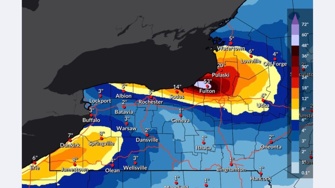
Heaviest Snow Focused East of Lake Ontario
The most intense lake-effect bands are expected to target central and northern portions of the state, particularly areas downwind of Lake Ontario. Forecast guidance highlights the potential for 20 inches or more in parts of the lake-effect snowbelt, with snowfall rates capable of rapidly reducing visibility and making travel difficult.
Nearby areas could see sharp gradients in totals, with some locations picking up only a few inches while others, just miles away, experience prolonged heavy snow.
Lighter Totals But Persistent Snow Elsewhere
Western and central sections of New York are still expected to see periods of light to moderate snow, with many areas falling into the 1 to 6 inch range over the multi-day event. While totals here may be lower, repeated snow showers and gusty winds could still create slick roads and reduced visibility at times.
The uneven nature of lake-effect snow means conditions can change quickly, even within short distances.
Travel and Safety Concerns
With snow expected to continue off and on for several days, impacts could compound over time. Bursts of heavier snowfall may lead to rapid accumulation, especially during overnight hours when temperatures remain cold enough for snow to efficiently pile up.
Residents and travelers should be prepared for localized travel disruptions, particularly in areas repeatedly hit by persistent snow bands.
What to Watch Going Forward
Lake-effect snow events are notoriously difficult to pin down precisely, and small shifts in wind direction could dramatically change where the heaviest snow sets up. Forecasters will continue refining snowfall expectations as the event unfolds.
For now, New York remains in an active winter pattern, with lake-effect snow once again reminding residents that winter impacts can vary sharply from one community to the next.
How is winter shaping up where you live? Share your local snowfall reports and follow ongoing weather coverage at ChicagoMusicGuide.com.